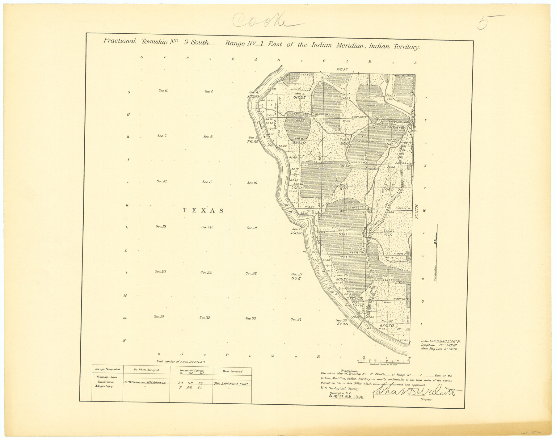
Fractional Township No. 9 South Range No. 1 East of the Indian Meridian, Indian Territory
-
Map/Doc
75201
-
Collection
General Map Collection
-
Object Dates
1898/3/2 (Creation Date)
-
Subjects
Texas Boundaries
-
Height x Width
19.2 x 24.4 inches
48.8 x 62.0 cm
Part of: General Map Collection
Flight Mission No. DAG-21K, Frame 86, Matagorda County

Print $20.00
- Digital $50.00
Flight Mission No. DAG-21K, Frame 86, Matagorda County
1952
Size 18.5 x 19.5 inches
Map/Doc 86415
Palo Pinto County Working Sketch 15

Print $20.00
- Digital $50.00
Palo Pinto County Working Sketch 15
1971
Size 26.4 x 30.8 inches
Map/Doc 71398
McLennan County Sketch File 19

Print $18.00
- Digital $50.00
McLennan County Sketch File 19
1889
Size 12.8 x 7.9 inches
Map/Doc 31284
Right of Way & Track Map, San Antonio & Aransas Pass Railway Co.

Print $40.00
- Digital $50.00
Right of Way & Track Map, San Antonio & Aransas Pass Railway Co.
1919
Size 25.3 x 56.6 inches
Map/Doc 64214
[Sketch for Mineral Application 31137 - Colorado River, W. A. Wagner]
![65634, [Sketch for Mineral Application 31137 - Colorado River, W. A. Wagner], General Map Collection](https://historictexasmaps.com/wmedia_w700/maps/65634.tif.jpg)
Print $40.00
- Digital $50.00
[Sketch for Mineral Application 31137 - Colorado River, W. A. Wagner]
1928
Size 39.6 x 126.2 inches
Map/Doc 65634
Harris County Working Sketch 107

Print $20.00
- Digital $50.00
Harris County Working Sketch 107
1981
Size 46.0 x 28.1 inches
Map/Doc 65999
Llano County Working Sketch 5

Print $20.00
- Digital $50.00
Llano County Working Sketch 5
1961
Size 43.1 x 34.4 inches
Map/Doc 70623
Fannin County Working Sketch 5

Print $20.00
- Digital $50.00
Fannin County Working Sketch 5
1939
Size 11.2 x 18.1 inches
Map/Doc 69159
Victoria County

Print $20.00
- Digital $50.00
Victoria County
1858
Size 26.5 x 29.2 inches
Map/Doc 4115
Cochran County Sketch File 4

Print $20.00
- Digital $50.00
Cochran County Sketch File 4
1931
Size 24.9 x 22.1 inches
Map/Doc 11100
Terrell County Working Sketch 31

Print $20.00
- Digital $50.00
Terrell County Working Sketch 31
1945
Size 26.8 x 27.8 inches
Map/Doc 62123
Harris County Working Sketch 39

Print $20.00
- Digital $50.00
Harris County Working Sketch 39
1940
Size 21.6 x 20.1 inches
Map/Doc 65931
You may also like
Cottle County Sketch File 16a

Print $64.00
- Digital $50.00
Cottle County Sketch File 16a
1911
Size 11.5 x 8.9 inches
Map/Doc 19522
Topographical Map of the Rio Grande, Sheet No. 16

Print $20.00
- Digital $50.00
Topographical Map of the Rio Grande, Sheet No. 16
1912
Map/Doc 89540
Taylor County Sketch File 1

Print $20.00
- Digital $50.00
Taylor County Sketch File 1
Size 33.3 x 40.8 inches
Map/Doc 10381
Brown County Sketch File 17

Print $40.00
- Digital $50.00
Brown County Sketch File 17
Size 15.6 x 12.7 inches
Map/Doc 16614
Atascosa County Sketch File 30

Print $18.00
- Digital $50.00
Atascosa County Sketch File 30
1900
Size 11.2 x 8.8 inches
Map/Doc 13816
Flight Mission No. DQN-5K, Frame 147, Calhoun County

Print $20.00
- Digital $50.00
Flight Mission No. DQN-5K, Frame 147, Calhoun County
1953
Size 18.5 x 22.1 inches
Map/Doc 84422
[Northeast Portion of Hartley County]
![91118, [Northeast Portion of Hartley County], Twichell Survey Records](https://historictexasmaps.com/wmedia_w700/maps/91118-1.tif.jpg)
Print $2.00
- Digital $50.00
[Northeast Portion of Hartley County]
Size 13.9 x 8.5 inches
Map/Doc 91118
McLennan County Sketch File 13

Print $4.00
- Digital $50.00
McLennan County Sketch File 13
1873
Size 10.7 x 8.1 inches
Map/Doc 31267
Nolan County Sketch File 15

Print $20.00
- Digital $50.00
Nolan County Sketch File 15
1929
Size 24.5 x 22.6 inches
Map/Doc 42165
Old Miscellaneous File 19

Print $32.00
- Digital $50.00
Old Miscellaneous File 19
Size 14.2 x 8.8 inches
Map/Doc 75499
Johnson County Rolled Sketch 4

Print $20.00
- Digital $50.00
Johnson County Rolled Sketch 4
Size 24.8 x 36.0 inches
Map/Doc 94047
Parker County Sketch File 5

Print $4.00
- Digital $50.00
Parker County Sketch File 5
1858
Size 8.1 x 8.2 inches
Map/Doc 33528