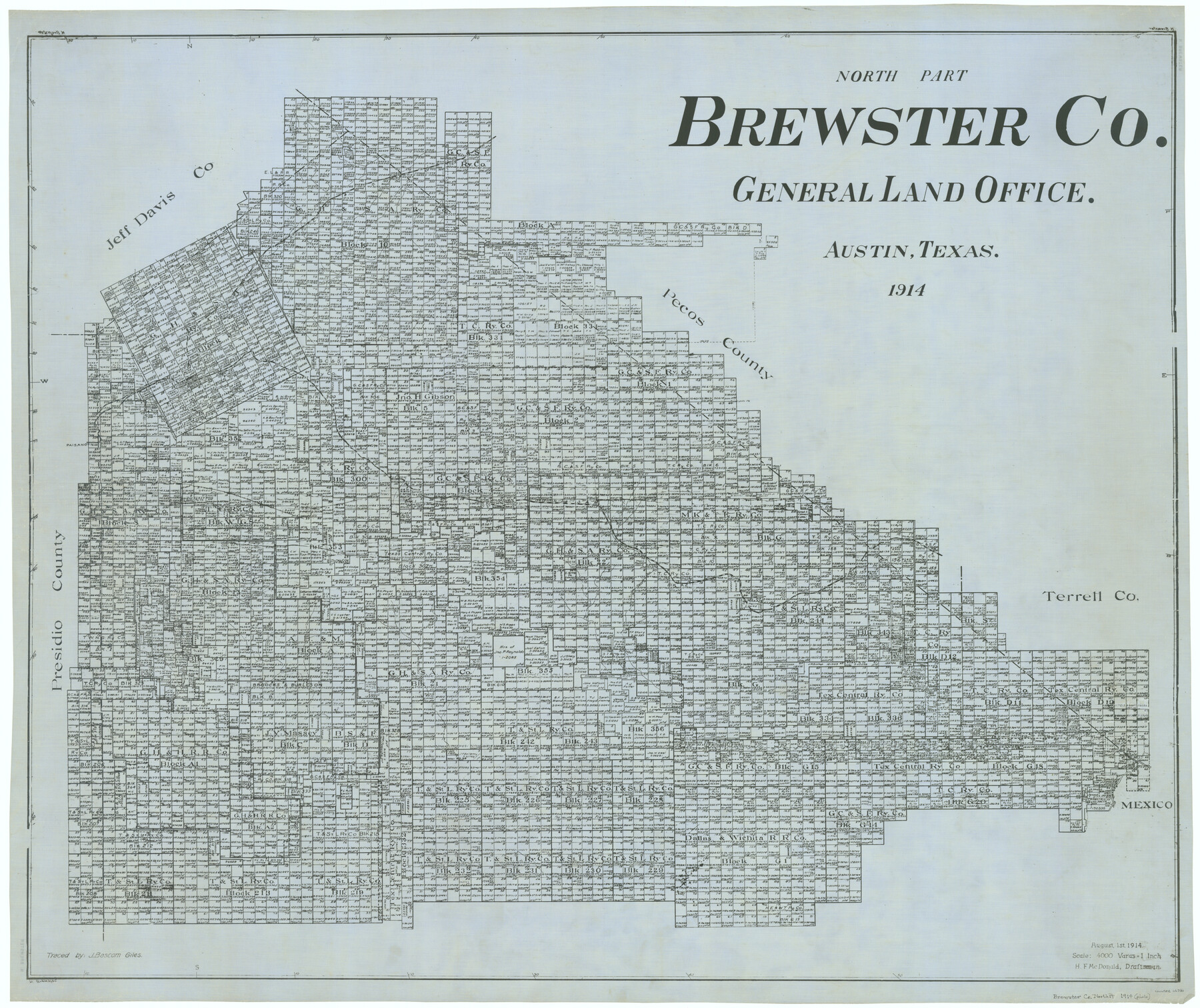
North Part Brewster Co.
-
Map/Doc
66730
-
Collection
General Map Collection
-
Object Dates
1914/8/1 (Creation Date)
-
People and Organizations
Texas General Land Office (Publisher)
H.F. McDonald (Compiler)
H.F. McDonald (Draftsman)
-
Counties
Brewster
-
Subjects
County
-
Height x Width
40.7 x 48.5 inches
103.4 x 123.2 cm
-
Comments
Traced by J. Bascom Giles.
Part of: General Map Collection

Sutton County Sketch File 44

Print $6.00
- Digital $50.00
Sutton County Sketch File 44
1939
Size 11.3 x 8.7 inches
Map/Doc 37512
Potter County Boundary File 1

Print $12.00
- Digital $50.00
Potter County Boundary File 1
Size 14.1 x 8.7 inches
Map/Doc 57937
Flight Mission No. CUG-1P, Frame 23, Kleberg County

Print $20.00
- Digital $50.00
Flight Mission No. CUG-1P, Frame 23, Kleberg County
1956
Size 18.5 x 22.1 inches
Map/Doc 86113
Martin County Sketch File 12

Print $20.00
- Digital $50.00
Martin County Sketch File 12
1937
Size 22.9 x 19.5 inches
Map/Doc 12030

Webb County Sketch File LM3

Print $20.00
- Digital $50.00
Webb County Sketch File LM3
1924
Size 24.7 x 31.9 inches
Map/Doc 12658
[Surveys along Bray's Bayou]
![157, [Surveys along Bray's Bayou], General Map Collection](https://historictexasmaps.com/wmedia_w700/maps/157.tif.jpg)
Print $2.00
- Digital $50.00
[Surveys along Bray's Bayou]
Size 7.6 x 4.9 inches
Map/Doc 157
Titus County Working Sketch 2

Print $20.00
- Digital $50.00
Titus County Working Sketch 2
Size 23.6 x 25.3 inches
Map/Doc 69363
Fannin County Sketch File 21

Print $4.00
- Digital $50.00
Fannin County Sketch File 21
1878
Size 10.5 x 8.4 inches
Map/Doc 22487
W. M. Kuykendall Ranch, Matagorda County, Texas

Print $20.00
- Digital $50.00
W. M. Kuykendall Ranch, Matagorda County, Texas
1926
Size 24.3 x 39.6 inches
Map/Doc 3028
Copy of Surveyor's Field Book, Morris Browning - In Blocks 7, 5 & 4, I&GNRRCo., Hutchinson and Carson Counties, Texas

Print $2.00
- Digital $50.00
Copy of Surveyor's Field Book, Morris Browning - In Blocks 7, 5 & 4, I&GNRRCo., Hutchinson and Carson Counties, Texas
1888
Size 6.9 x 8.9 inches
Map/Doc 62285
You may also like
Dimmit County Working Sketch 58

Print $20.00
- Digital $50.00
Dimmit County Working Sketch 58
2017
Size 24.2 x 36.2 inches
Map/Doc 94121
Wood County Working Sketch 17

Print $20.00
- Digital $50.00
Wood County Working Sketch 17
Size 24.0 x 31.3 inches
Map/Doc 62017
Tarrant County Sketch File 16

Print $4.00
- Digital $50.00
Tarrant County Sketch File 16
1861
Size 8.2 x 6.4 inches
Map/Doc 37710
Flight Mission No. CRC-5R, Frame 21, Chambers County

Print $20.00
- Digital $50.00
Flight Mission No. CRC-5R, Frame 21, Chambers County
1956
Size 18.6 x 22.3 inches
Map/Doc 84943
Val Verde County Working Sketch 58

Print $20.00
- Digital $50.00
Val Verde County Working Sketch 58
1958
Size 21.0 x 22.8 inches
Map/Doc 72193
Concho County
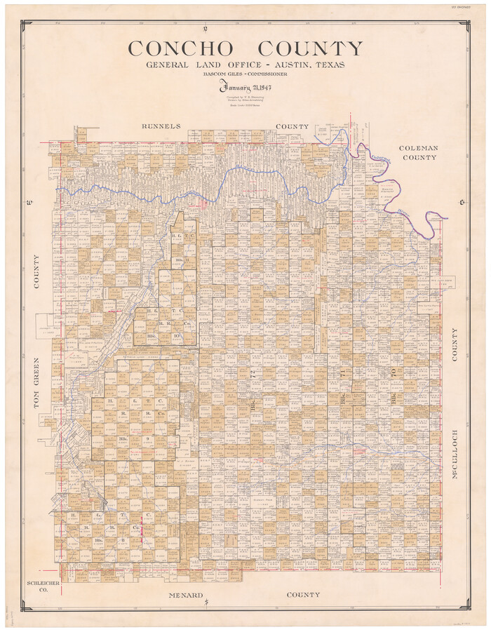
Print $20.00
- Digital $50.00
Concho County
1947
Size 46.8 x 36.9 inches
Map/Doc 73115
Flight Mission No. CGI-4N, Frame 185, Cameron County

Print $20.00
- Digital $50.00
Flight Mission No. CGI-4N, Frame 185, Cameron County
1955
Size 18.6 x 22.3 inches
Map/Doc 84688
Hunt Co., 1894

Print $40.00
- Digital $50.00
Hunt Co., 1894
1894
Size 30.3 x 49.2 inches
Map/Doc 89652
Hardin County Working Sketch 36

Print $40.00
- Digital $50.00
Hardin County Working Sketch 36
1981
Size 76.8 x 37.5 inches
Map/Doc 63434
Baylor County Sketch File 22

Print $10.00
- Digital $50.00
Baylor County Sketch File 22
1913
Size 11.2 x 8.8 inches
Map/Doc 14199
Topographical Map of the Rio Grande, Sheet No. 8

Print $20.00
- Digital $50.00
Topographical Map of the Rio Grande, Sheet No. 8
1912
Map/Doc 89532
Outer Continental Shelf Leasing Maps (Louisiana Offshore Operations)

Print $20.00
- Digital $50.00
Outer Continental Shelf Leasing Maps (Louisiana Offshore Operations)
1954
Size 22.2 x 12.0 inches
Map/Doc 76096