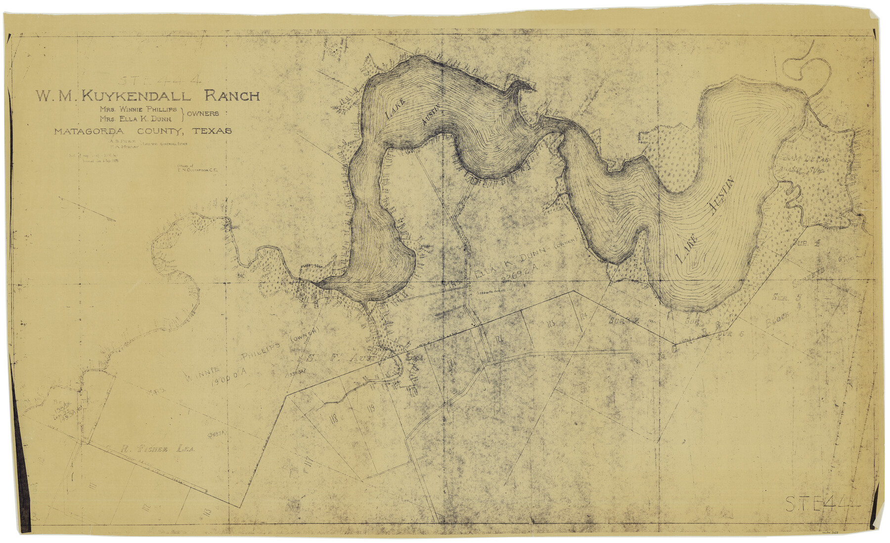
W. M. Kuykendall Ranch, Matagorda County, Texas
N-2-106
-
Map/Doc
3028
-
Collection
General Map Collection
-
Object Dates
1926 (Creation Date)
-
People and Organizations
E.N. Gustafson (Author)
-
Counties
Matagorda
-
Height x Width
24.3 x 39.6 inches
61.7 x 100.6 cm
-
Comments
Mrs. Winnie Phillips, Mrs. Ella K. Dunn, Owners. Job No. Ste-444. See N-2-105 (Job No. Stf-652) and N-2-106 (Stf-651).
Part of: General Map Collection
Amistad International Reservoir on Rio Grande 86

Print $20.00
- Digital $50.00
Amistad International Reservoir on Rio Grande 86
1949
Size 28.3 x 40.1 inches
Map/Doc 75515
Wichita County Sketch File 5

Print $14.00
- Digital $50.00
Wichita County Sketch File 5
Size 8.2 x 14.5 inches
Map/Doc 40038
Flight Mission No. CRC-4R, Frame 182, Chambers County

Print $20.00
- Digital $50.00
Flight Mission No. CRC-4R, Frame 182, Chambers County
1956
Size 18.5 x 22.1 inches
Map/Doc 84933
Hemphill County Working Sketch 18

Print $20.00
- Digital $50.00
Hemphill County Working Sketch 18
1972
Size 33.7 x 41.6 inches
Map/Doc 66113
Val Verde County Sketch File 15 and 16

Print $60.00
- Digital $50.00
Val Verde County Sketch File 15 and 16
1883
Size 8.9 x 4.1 inches
Map/Doc 39207
South Montgomery County, Woodlands Chamber of Commerce Street Map

South Montgomery County, Woodlands Chamber of Commerce Street Map
Size 50.0 x 37.9 inches
Map/Doc 94363
Kimble County Working Sketch 20

Print $20.00
- Digital $50.00
Kimble County Working Sketch 20
1929
Size 36.2 x 27.8 inches
Map/Doc 70088
Terrell County Working Sketch 8a

Print $20.00
- Digital $50.00
Terrell County Working Sketch 8a
1917
Size 14.5 x 19.4 inches
Map/Doc 62157
Anderson County Sketch File 18

Print $40.00
- Digital $50.00
Anderson County Sketch File 18
1880
Size 16.0 x 13.5 inches
Map/Doc 10801
Flight Mission No. BQR-9K, Frame 15, Brazoria County

Print $20.00
- Digital $50.00
Flight Mission No. BQR-9K, Frame 15, Brazoria County
1952
Size 18.8 x 22.5 inches
Map/Doc 84044
Fisher County Working Sketch 17

Print $20.00
- Digital $50.00
Fisher County Working Sketch 17
1972
Size 32.2 x 24.6 inches
Map/Doc 69151
Topographical Map of the Rio Grande, Sheet No. 1

Print $20.00
- Digital $50.00
Topographical Map of the Rio Grande, Sheet No. 1
1912
Map/Doc 89525
You may also like
Sterling County Sketch File 11

Print $40.00
- Digital $50.00
Sterling County Sketch File 11
1929
Size 14.2 x 17.2 inches
Map/Doc 37148
Jeff Davis County Rolled Sketch 32

Print $20.00
- Digital $50.00
Jeff Davis County Rolled Sketch 32
1984
Size 16.3 x 24.5 inches
Map/Doc 7721
Bell County Working Sketch 3

Print $3.00
- Digital $50.00
Bell County Working Sketch 3
1940
Size 10.8 x 12.8 inches
Map/Doc 67343
A true copy of Peck's field book No. 7 pages 50 to 55, except classfication of lands

Print $40.00
- Digital $50.00
A true copy of Peck's field book No. 7 pages 50 to 55, except classfication of lands
Size 6.1 x 54.3 inches
Map/Doc 89666
Erath County Working Sketch 35

Print $20.00
- Digital $50.00
Erath County Working Sketch 35
1973
Size 24.8 x 28.4 inches
Map/Doc 69116
Location of the Southern Kansas Railway of Texas, Roberts County, Texas

Print $40.00
- Digital $50.00
Location of the Southern Kansas Railway of Texas, Roberts County, Texas
1887
Size 20.0 x 75.1 inches
Map/Doc 64037
Working Sketch in Wichita County [in northern part of county]
![91992, Working Sketch in Wichita County [in northern part of county], Twichell Survey Records](https://historictexasmaps.com/wmedia_w700/maps/91992-1.tif.jpg)
Print $20.00
- Digital $50.00
Working Sketch in Wichita County [in northern part of county]
1919
Size 38.3 x 18.5 inches
Map/Doc 91992

[H. & T. C. Blocks 47 1/2 and 50]
![90643, [H. & T. C. Blocks 47 1/2 and 50], Twichell Survey Records](https://historictexasmaps.com/wmedia_w700/maps/90643-1.tif.jpg)
Print $20.00
- Digital $50.00
[H. & T. C. Blocks 47 1/2 and 50]
Size 35.5 x 16.8 inches
Map/Doc 90643
McCulloch County Sketch File 8

Print $4.00
- Digital $50.00
McCulloch County Sketch File 8
1904
Size 11.3 x 8.7 inches
Map/Doc 31182
Gregg County Rolled Sketch 20

Print $20.00
- Digital $50.00
Gregg County Rolled Sketch 20
1957
Size 34.6 x 44.7 inches
Map/Doc 6478
Texas Panhandle East Boundary Line

Print $20.00
- Digital $50.00
Texas Panhandle East Boundary Line
1898
Size 32.1 x 8.8 inches
Map/Doc 1700