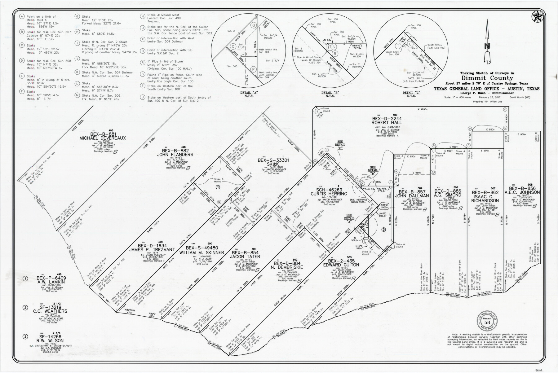
Dimmit County Working Sketch 58
-
Map/Doc
94121
-
Collection
General Map Collection
-
Object Dates
2/23/2017 (Creation Date)
-
People and Organizations
David Harris (Draftsman)
-
Counties
Dimmit
-
Subjects
Surveying Working Sketch
-
Height x Width
24.2 x 36.2 inches
61.5 x 92.0 cm
-
Medium
mylar, print
-
Scale
1" = 400 varas
Part of: General Map Collection
Panola County Sketch File 4

Print $4.00
- Digital $50.00
Panola County Sketch File 4
1860
Size 8.9 x 8.9 inches
Map/Doc 33449
Hopkins County Working Sketch 4

Print $20.00
- Digital $50.00
Hopkins County Working Sketch 4
1959
Size 23.3 x 30.9 inches
Map/Doc 66229
Brazos Santiago & Boca Chica entrances, Texas

Print $20.00
- Digital $50.00
Brazos Santiago & Boca Chica entrances, Texas
1867
Size 18.1 x 25.6 inches
Map/Doc 72927
Chambers County Working Sketch 17

Print $20.00
- Digital $50.00
Chambers County Working Sketch 17
1964
Size 30.6 x 37.0 inches
Map/Doc 68000
Gaines County Rolled Sketch G3

Print $20.00
- Digital $50.00
Gaines County Rolled Sketch G3
1902
Size 22.7 x 31.4 inches
Map/Doc 5946
Flight Mission No. DCL-7C, Frame 45, Kenedy County

Print $20.00
- Digital $50.00
Flight Mission No. DCL-7C, Frame 45, Kenedy County
1943
Size 15.4 x 15.3 inches
Map/Doc 86033
Gregg County Rolled Sketch 20

Print $20.00
- Digital $50.00
Gregg County Rolled Sketch 20
1957
Size 34.6 x 44.7 inches
Map/Doc 6478
Current Miscellaneous File 23

Print $4.00
- Digital $50.00
Current Miscellaneous File 23
1953
Size 14.1 x 5.5 inches
Map/Doc 73881
Crockett County Working Sketch 80

Print $20.00
- Digital $50.00
Crockett County Working Sketch 80
1973
Size 28.1 x 26.1 inches
Map/Doc 68413
Motley County Sketch File 6 (N)

Print $20.00
- Digital $50.00
Motley County Sketch File 6 (N)
1900
Size 14.0 x 8.6 inches
Map/Doc 32004
El Paso County Sketch File 34

Print $82.00
- Digital $50.00
El Paso County Sketch File 34
1984
Size 14.3 x 8.9 inches
Map/Doc 22129
Flight Mission No. BRE-1P, Frame 55, Nueces County

Print $20.00
- Digital $50.00
Flight Mission No. BRE-1P, Frame 55, Nueces County
1956
Size 18.3 x 22.2 inches
Map/Doc 86644
You may also like
Flight Mission No. BRA-7M, Frame 195, Jefferson County

Print $20.00
- Digital $50.00
Flight Mission No. BRA-7M, Frame 195, Jefferson County
1953
Size 18.5 x 22.4 inches
Map/Doc 85563
[Block D3, Block A, Block O]
![92750, [Block D3, Block A, Block O], Twichell Survey Records](https://historictexasmaps.com/wmedia_w700/maps/92750-1.tif.jpg)
Print $20.00
- Digital $50.00
[Block D3, Block A, Block O]
Size 25.2 x 13.1 inches
Map/Doc 92750
Engineer's Office, Department of the Gulf Map No. 59, Texas prepared by order of Maj. Gen. N. P. Banks under direction of Capt. P. C. Hains, U. S. Engr. & Chief Engr., Dept. of the Gulf

Print $20.00
- Digital $50.00
Engineer's Office, Department of the Gulf Map No. 59, Texas prepared by order of Maj. Gen. N. P. Banks under direction of Capt. P. C. Hains, U. S. Engr. & Chief Engr., Dept. of the Gulf
1865
Size 18.2 x 27.5 inches
Map/Doc 72718
Kendall County Sketch File 24

Print $8.00
- Digital $50.00
Kendall County Sketch File 24
Size 13.1 x 8.7 inches
Map/Doc 28718
Hutchinson County Sketch File 53

Print $2.00
- Digital $50.00
Hutchinson County Sketch File 53
2000
Size 11.2 x 8.8 inches
Map/Doc 27455
Map of Henderson County

Print $20.00
- Digital $50.00
Map of Henderson County
1871
Size 16.0 x 31.4 inches
Map/Doc 3665
Irion County Working Sketch 14

Print $40.00
- Digital $50.00
Irion County Working Sketch 14
1973
Size 56.3 x 30.8 inches
Map/Doc 66423
Gaines County Rolled Sketch 26

Print $20.00
- Digital $50.00
Gaines County Rolled Sketch 26
1980
Size 28.0 x 15.5 inches
Map/Doc 5940
Gonzales County Working Sketch Graphic Index

Print $40.00
- Digital $50.00
Gonzales County Working Sketch Graphic Index
1986
Size 40.2 x 53.0 inches
Map/Doc 76556
Portion of Pecos County

Print $20.00
- Digital $50.00
Portion of Pecos County
Size 18.8 x 21.6 inches
Map/Doc 91589
Angelina County Working Sketch 28

Print $20.00
- Digital $50.00
Angelina County Working Sketch 28
1954
Size 28.9 x 26.0 inches
Map/Doc 67110
San Jacinto County

Print $20.00
- Digital $50.00
San Jacinto County
1942
Size 47.1 x 42.8 inches
Map/Doc 63017