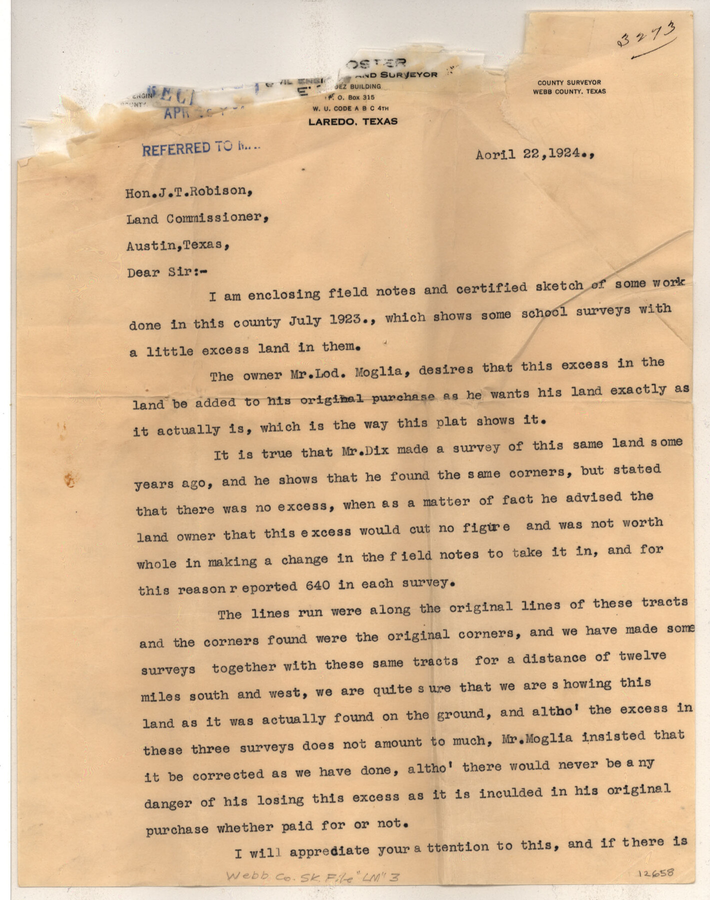
Webb County Sketch File LM3
[Map and statement regarding survey made of Lod Moglias lands in eastern Webb County near the Duval County line]
- 
                          Map/Doc
12658
 - 
                            Collection
General Map Collection
 - 
                            Object Dates
4/22/1924 (Creation Date)
4/23/1924 (File Date)
 - 
                            People and Organizations
E.J. Foster (Surveyor/Engineer)
 - 
                            Counties
Webb
 - 
                            Subjects
Surveying Sketch File
 - 
                            Height x Width
24.7 x 31.9 inches
62.7 x 81.0 cm
 - 
                            Medium
multi-page, multi-format
 - 
                            Features
Romaldana Ranch
San Pablo Ranch
Escarpment
Encino Sola Ranch
 
Part of: General Map Collection
            El Paso County Rolled Sketch Z55


                                            Print $40.00                    
                                             -                         Digital $50.00                                    
                El Paso County Rolled Sketch Z55
1915
Size 36.8 x 49.4 inches
                                Map/Doc 8870
            
            Lynn County Working Sketch 5


                                            Print $20.00                    
                                             -                         Digital $50.00                                    
                Lynn County Working Sketch 5
1982
Size 22.5 x 28.2 inches
                                Map/Doc 70675
            
            Midland County Working Sketch 14


                                            Print $40.00                    
                                             -                         Digital $50.00                                    
                Midland County Working Sketch 14
1953
Size 65.0 x 31.0 inches
                                Map/Doc 70994
            
            Hudspeth County Sketch File 14


                                            Print $12.00                    
                                             -                         Digital $50.00                                    
                Hudspeth County Sketch File 14
1915
Size 14.3 x 8.8 inches
                                Map/Doc 26938
            
            Maverick County Rolled Sketch 19


                                            Print $20.00                    
                                             -                         Digital $50.00                                    
                Maverick County Rolled Sketch 19
1955
Size 33.5 x 44.1 inches
                                Map/Doc 9494
            
            Map of Throckmorton County Young Land District


                                            Print $20.00                    
                                             -                         Digital $50.00                                    
                Map of Throckmorton County Young Land District
1859
Size 25.2 x 20.3 inches
                                Map/Doc 4078
            
            Edwards County Working Sketch 11


                                            Print $20.00                    
                                             -                         Digital $50.00                                    
                Edwards County Working Sketch 11
1922
Size 18.8 x 31.7 inches
                                Map/Doc 68887
            
            Montgomery County Rolled Sketch 33


                                            Print $40.00                    
                                             -                         Digital $50.00                                    
                Montgomery County Rolled Sketch 33
1953
Size 48.1 x 39.6 inches
                                Map/Doc 9541
            
            Andrews County Working Sketch 19


                                            Print $20.00                    
                                             -                         Digital $50.00                                    
                Andrews County Working Sketch 19
1964
Size 24.9 x 23.5 inches
                                Map/Doc 67065
            
            Lavaca County Rolled Sketch 3


                                            Print $20.00                    
                                             -                         Digital $50.00                                    
                Lavaca County Rolled Sketch 3
1959
Size 42.8 x 32.8 inches
                                Map/Doc 9419
            
            San Patricio County Rolled Sketch 20


                                            Print $20.00                    
                                             -                         Digital $50.00                                    
                San Patricio County Rolled Sketch 20
1953
Size 37.6 x 31.9 inches
                                Map/Doc 7578
            
            Live Oak County Working Sketch 13


                                            Print $20.00                    
                                             -                         Digital $50.00                                    
                Live Oak County Working Sketch 13
1957
Size 42.1 x 38.7 inches
                                Map/Doc 70598
            You may also like
            Sheet 3 copied from Champlin Book 5 [Strip Map showing T. & P. connecting lines]


                                            Print $40.00                    
                                             -                         Digital $50.00                                    
                Sheet 3 copied from Champlin Book 5 [Strip Map showing T. & P. connecting lines]
1909
Size 7.5 x 74.8 inches
                                Map/Doc 93179
            
            Midland County Working Sketch 27


                                            Print $20.00                    
                                             -                         Digital $50.00                                    
                Midland County Working Sketch 27
1963
Size 41.6 x 38.9 inches
                                Map/Doc 71008
            
            Dawson County Sketch File 14


                                            Print $4.00                    
                                             -                         Digital $50.00                                    
                Dawson County Sketch File 14
Size 11.5 x 7.5 inches
                                Map/Doc 20547
            
            Edwards County Sketch File 23


                                            Print $8.00                    
                                             -                         Digital $50.00                                    
                Edwards County Sketch File 23
1881
Size 14.4 x 9.0 inches
                                Map/Doc 21747
            
            Hunt County Working Sketch 9


                                            Print $20.00                    
                                             -                         Digital $50.00                                    
                Hunt County Working Sketch 9
1959
Size 33.8 x 30.6 inches
                                Map/Doc 66356
            
            Reynolds's Political Map of the United States Designed to Exhibit the Comparative Area of the Free and Slave States and the Territory open to Slavery or Freedom by the Repeal of the Missouri Compromise


                                            Print $20.00                    
                                             -                         Digital $50.00                                    
                Reynolds's Political Map of the United States Designed to Exhibit the Comparative Area of the Free and Slave States and the Territory open to Slavery or Freedom by the Repeal of the Missouri Compromise
1856
Size 24.0 x 27.0 inches
                                Map/Doc 97115
            
            Dumas, Moore County, Texas


                                            Print $20.00                    
                                             -                         Digital $50.00                                    
                Dumas, Moore County, Texas
1891
Size 13.4 x 15.7 inches
                                Map/Doc 92111
            
            Webb County Working Sketch 24


                                            Print $20.00                    
                                             -                         Digital $50.00                                    
                Webb County Working Sketch 24
1928
Size 24.5 x 23.9 inches
                                Map/Doc 72389
            
            [St. L. S.-W. Ry. of Texas, Map of Lufkin Branch in Smith County, Texas]


                                            Print $40.00                    
                                             -                         Digital $50.00                                    
                [St. L. S.-W. Ry. of Texas, Map of Lufkin Branch in Smith County, Texas]
1912
Size 24.2 x 121.2 inches
                                Map/Doc 64693
            
            [Sketch for Mineral Application 15273 - Sabine River Bed]


                                            Print $20.00                    
                                             -                         Digital $50.00                                    
                [Sketch for Mineral Application 15273 - Sabine River Bed]
1926
Size 45.4 x 28.1 inches
                                Map/Doc 65576
            
            Map showing eight tidal areas in Oso Bay and Oso Creek, Nueces County, Texas offered for Mineral Development


                                            Print $20.00                    
                                             -                         Digital $50.00                                    
                Map showing eight tidal areas in Oso Bay and Oso Creek, Nueces County, Texas offered for Mineral Development
1936
Size 17.9 x 29.7 inches
                                Map/Doc 2067
            
            [Texas Boundary Line]


                                            Print $20.00                    
                                             -                         Digital $50.00                                    
                [Texas Boundary Line]
Size 21.7 x 12.1 inches
                                Map/Doc 92080