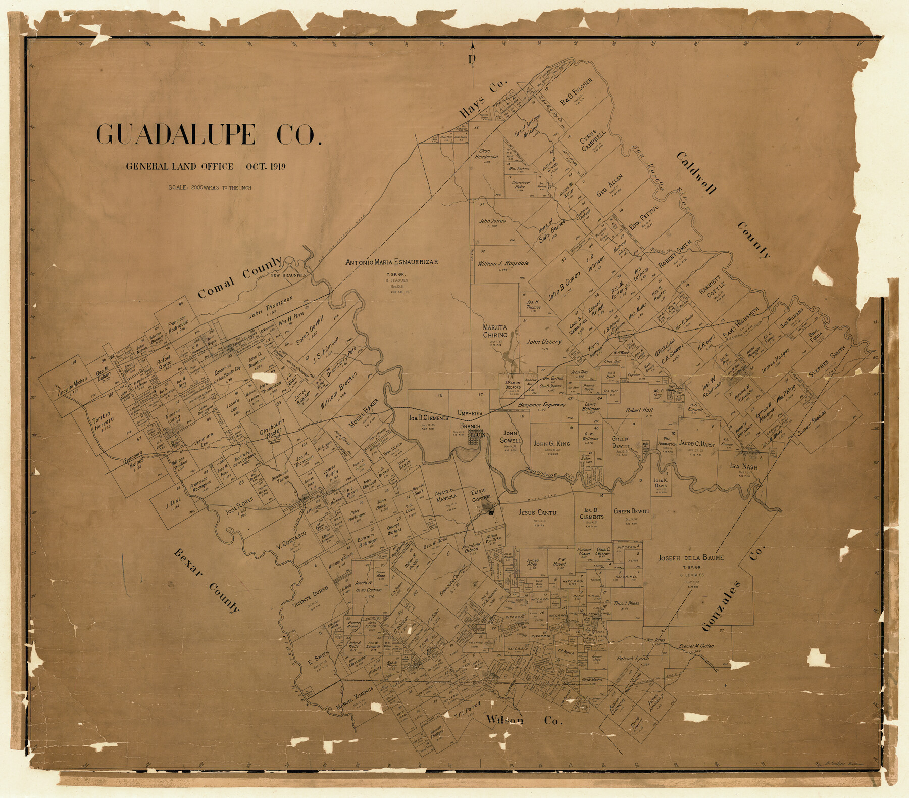
Guadalupe Co.
-
Map/Doc
4692
-
Collection
General Map Collection
-
Object Dates
10/1919 (Creation Date)
-
People and Organizations
Texas General Land Office (Publisher)
Fr. Matzow (Draftsman)
Fr. Matzow (Compiler)
-
Counties
Guadalupe
-
Subjects
County
-
Height x Width
39.8 x 45.4 inches
101.1 x 115.3 cm
-
Medium
paper, manuscript
-
Features
Seguin
Eclato Creek
Sandy Creek
Cibolo River
Elm Creek
Gonzales Road
Castlemans Creek
Nash Creek
Mill Creek
Mill Road
Cottonwood Creek
Guadalupe River
New Braunfels
Santa Clara Creek
Seguin Road
Yorks Creek
Highsmith Creek
Kingsbury
San Marcos River
Old San Antonio Road
GH&SA
Marion
Comal Creek
Part of: General Map Collection
Flight Mission No. DQN-1K, Frame 30, Calhoun County

Print $20.00
- Digital $50.00
Flight Mission No. DQN-1K, Frame 30, Calhoun County
1953
Size 18.6 x 22.2 inches
Map/Doc 84135
Flight Mission No. CGI-3N, Frame 160, Cameron County

Print $20.00
- Digital $50.00
Flight Mission No. CGI-3N, Frame 160, Cameron County
1954
Size 18.5 x 22.3 inches
Map/Doc 84624
Pecos County Rolled Sketch 19

Print $21.00
- Digital $50.00
Pecos County Rolled Sketch 19
1885
Size 9.4 x 14.7 inches
Map/Doc 48082
Comal County Sketch File 13

Print $8.00
- Digital $50.00
Comal County Sketch File 13
1866
Size 9.5 x 14.9 inches
Map/Doc 19026
Flight Mission No. DQN-2K, Frame 66, Calhoun County

Print $20.00
- Digital $50.00
Flight Mission No. DQN-2K, Frame 66, Calhoun County
1953
Size 18.9 x 22.3 inches
Map/Doc 84258
Preliminary Chart No. 31 of the Sea Coast of the United States from Galveston Bay to Matagorda Bay, Texas

Print $20.00
- Digital $50.00
Preliminary Chart No. 31 of the Sea Coast of the United States from Galveston Bay to Matagorda Bay, Texas
1857
Size 22.7 x 38.7 inches
Map/Doc 69949
Wharton County Boundary File 1

Print $24.00
- Digital $50.00
Wharton County Boundary File 1
Size 14.2 x 8.9 inches
Map/Doc 59839

Fort Bend County Sketch File 28

Print $40.00
- Digital $50.00
Fort Bend County Sketch File 28
Size 13.7 x 8.6 inches
Map/Doc 22979
Sulphur River, Ringo Crossing Sheet

Print $20.00
- Digital $50.00
Sulphur River, Ringo Crossing Sheet
1933
Size 18.5 x 20.4 inches
Map/Doc 78334
The City of Austin and Suburbs

Print $40.00
- Digital $50.00
The City of Austin and Suburbs
1919
Size 120.7 x 43.9 inches
Map/Doc 88862
Padre Island National Seashore

Print $4.00
- Digital $50.00
Padre Island National Seashore
Size 16.1 x 22.1 inches
Map/Doc 60531
You may also like
General Highway Map, Floyd County, Texas

Print $20.00
General Highway Map, Floyd County, Texas
1961
Size 24.6 x 18.1 inches
Map/Doc 79467
Brazoria County Sketch File 28

Print $6.00
- Digital $50.00
Brazoria County Sketch File 28
1889
Size 8.8 x 14.2 inches
Map/Doc 15030
Menard County Working Sketch 17

Print $40.00
- Digital $50.00
Menard County Working Sketch 17
1946
Size 59.0 x 42.9 inches
Map/Doc 70964
Menard County

Print $20.00
- Digital $50.00
Menard County
1942
Size 40.1 x 43.7 inches
Map/Doc 66928
Glasscock County Rolled Sketch 15

Print $20.00
- Digital $50.00
Glasscock County Rolled Sketch 15
1964
Size 36.5 x 35.8 inches
Map/Doc 9059
No. 3 Chart of Channel connecting Corpus Christi Bay with Aransas Bay, Texas

Print $20.00
- Digital $50.00
No. 3 Chart of Channel connecting Corpus Christi Bay with Aransas Bay, Texas
1878
Size 18.4 x 28.0 inches
Map/Doc 72771
South Part Presidio County

Print $20.00
- Digital $50.00
South Part Presidio County
1975
Size 35.0 x 40.3 inches
Map/Doc 95617
Hays County Working Sketch 18

Print $20.00
- Digital $50.00
Hays County Working Sketch 18
1978
Size 33.4 x 32.0 inches
Map/Doc 66092
Burnet County Sketch File 43

Print $8.00
- Digital $50.00
Burnet County Sketch File 43
1856
Size 9.4 x 6.0 inches
Map/Doc 16763
Hill County Sketch File 17

Print $4.00
- Digital $50.00
Hill County Sketch File 17
1860
Size 12.5 x 8.3 inches
Map/Doc 26484
Flight Mission No. BRA-6M, Frame 80, Jefferson County

Print $20.00
- Digital $50.00
Flight Mission No. BRA-6M, Frame 80, Jefferson County
1953
Size 18.6 x 22.3 inches
Map/Doc 85424
[Sketch Showing Wm. T. Brewer, John R. Taylor, Wm. F. Butler, Timothy DeVore, L. M. Thorn and adjoining surveys]
![90231, [Sketch Showing Wm. T. Brewer, John R. Taylor, Wm. F. Butler, Timothy DeVore, L. M. Thorn and adjoining surveys], Twichell Survey Records](https://historictexasmaps.com/wmedia_w700/maps/90231-1.tif.jpg)
Print $20.00
- Digital $50.00
[Sketch Showing Wm. T. Brewer, John R. Taylor, Wm. F. Butler, Timothy DeVore, L. M. Thorn and adjoining surveys]
Size 27.2 x 19.4 inches
Map/Doc 90231