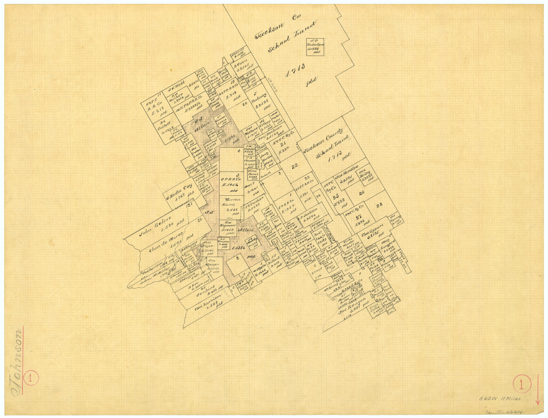
Johnson County Working Sketch 1
-
Map/Doc
66614
-
Collection
General Map Collection
-
Counties
Johnson
-
Subjects
Surveying Working Sketch
-
Height x Width
16.3 x 21.3 inches
41.4 x 54.1 cm
Part of: General Map Collection
Sabine River, Toll Bridge Sheet

Print $40.00
- Digital $50.00
Sabine River, Toll Bridge Sheet
1933
Size 27.8 x 51.9 inches
Map/Doc 65136
Lampasas County Working Sketch 7

Print $20.00
- Digital $50.00
Lampasas County Working Sketch 7
1951
Size 30.7 x 36.3 inches
Map/Doc 70284
Flight Mission No. BQR-4K, Frame 62, Brazoria County

Print $20.00
- Digital $50.00
Flight Mission No. BQR-4K, Frame 62, Brazoria County
1952
Size 18.9 x 22.5 inches
Map/Doc 83995
Maps of Gulf Intracoastal Waterway, Texas - Sabine River to the Rio Grande and connecting waterways including ship channels

Print $20.00
- Digital $50.00
Maps of Gulf Intracoastal Waterway, Texas - Sabine River to the Rio Grande and connecting waterways including ship channels
1966
Size 14.5 x 22.3 inches
Map/Doc 61948
Grimes County Working Sketch 3

Print $20.00
- Digital $50.00
Grimes County Working Sketch 3
1946
Size 34.1 x 29.1 inches
Map/Doc 63294
Runnels County Sketch File 21A

Print $20.00
Runnels County Sketch File 21A
1886
Size 17.5 x 20.5 inches
Map/Doc 12256
San Patricio County NRC Article 33.136 Location Key Sheet

Print $20.00
- Digital $50.00
San Patricio County NRC Article 33.136 Location Key Sheet
1975
Size 27.0 x 23.0 inches
Map/Doc 87914
Andrews County Rolled Sketch 11

Print $20.00
- Digital $50.00
Andrews County Rolled Sketch 11
1933
Size 28.0 x 37.7 inches
Map/Doc 77161
Terrell County Sketch File 2-3

Print $38.00
- Digital $50.00
Terrell County Sketch File 2-3
1882
Size 9.1 x 7.7 inches
Map/Doc 37879
Brewster County Sketch File NS-13

Print $4.00
- Digital $50.00
Brewster County Sketch File NS-13
1955
Size 11.1 x 8.8 inches
Map/Doc 16220
Map of Hays County, Texas

Print $20.00
- Digital $50.00
Map of Hays County, Texas
1880
Size 41.8 x 35.8 inches
Map/Doc 16848
Midland County Sketch File 7

Print $20.00
- Digital $50.00
Midland County Sketch File 7
1930
Size 33.1 x 23.7 inches
Map/Doc 12083
You may also like
Jackson County Rolled Sketch 15

Print $40.00
- Digital $50.00
Jackson County Rolled Sketch 15
1945
Size 53.7 x 30.3 inches
Map/Doc 9261
Coast Chart No. 210 Aransas Pass and Corpus Christi Bay with the coast to latitude 27° 12' Texas

Print $20.00
- Digital $50.00
Coast Chart No. 210 Aransas Pass and Corpus Christi Bay with the coast to latitude 27° 12' Texas
1887
Size 27.6 x 18.3 inches
Map/Doc 72790
Upton County Sketch File 38

Print $8.00
- Digital $50.00
Upton County Sketch File 38
1953
Size 11.1 x 8.9 inches
Map/Doc 38903
[Part of Block GG and river sections 69-79]
![90470, [Part of Block GG and river sections 69-79], Twichell Survey Records](https://historictexasmaps.com/wmedia_w700/maps/90470-1.tif.jpg)
Print $20.00
- Digital $50.00
[Part of Block GG and river sections 69-79]
Size 43.2 x 31.2 inches
Map/Doc 90470
Map of Menard County Texas

Print $20.00
- Digital $50.00
Map of Menard County Texas
1894
Size 33.0 x 42.5 inches
Map/Doc 66927
Plan of Mier. The Texian Camp and Attack on the City

Print $20.00
Plan of Mier. The Texian Camp and Attack on the City
1842
Size 8.7 x 11.4 inches
Map/Doc 76305
[Surveys in Waller County]
![78367, [Surveys in Waller County], General Map Collection](https://historictexasmaps.com/wmedia_w700/maps/78367.tif.jpg)
Print $20.00
- Digital $50.00
[Surveys in Waller County]
Size 21.5 x 28.7 inches
Map/Doc 78367
Webb County Sketch File 62

Print $6.00
- Digital $50.00
Webb County Sketch File 62
1946
Size 11.5 x 9.0 inches
Map/Doc 39862
Galveston County Sketch File 33

Print $12.00
- Digital $50.00
Galveston County Sketch File 33
1934
Size 11.2 x 8.8 inches
Map/Doc 23413
Fayette County, Texas

Print $20.00
- Digital $50.00
Fayette County, Texas
1879
Size 19.9 x 23.0 inches
Map/Doc 419
Maps of Gulf Intracoastal Waterway, Texas - Sabine River to the Rio Grande and connecting waterways including ship channels

Print $20.00
- Digital $50.00
Maps of Gulf Intracoastal Waterway, Texas - Sabine River to the Rio Grande and connecting waterways including ship channels
1966
Size 14.6 x 22.3 inches
Map/Doc 61956
Jefferson County Rolled Sketch 49

Print $40.00
- Digital $50.00
Jefferson County Rolled Sketch 49
1963
Size 32.5 x 57.4 inches
Map/Doc 66844