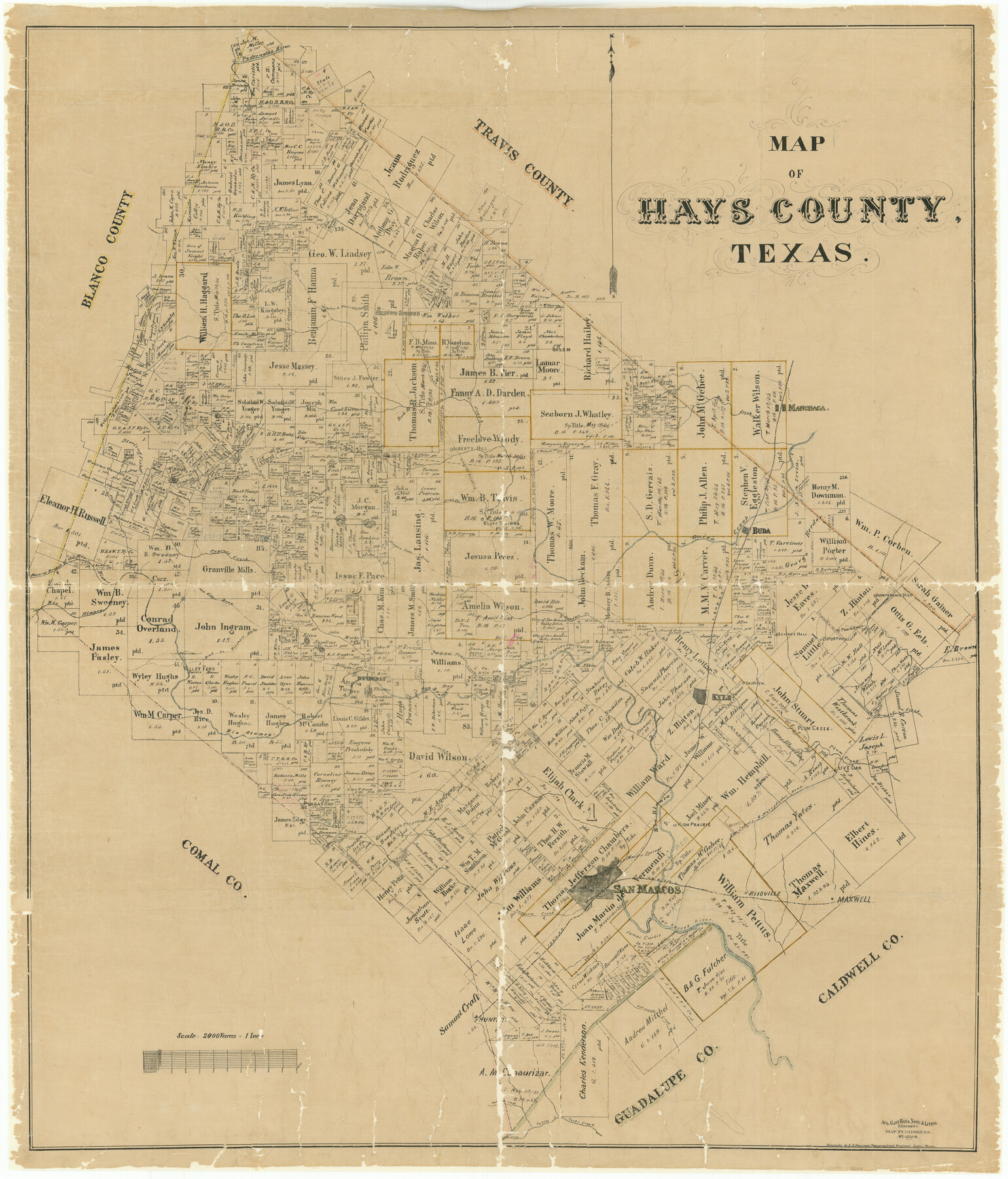
Map of Hays County, Texas
-
Map/Doc
16848
-
Collection
General Map Collection
-
Object Dates
1880 (Creation Date)
-
People and Organizations
E.A. Hausmann (Draftsman)
August Gast Bank Note & Lithograph Company (Lithographer)
-
Counties
Hays
-
Subjects
County
-
Height x Width
41.8 x 35.8 inches
106.2 x 90.9 cm
-
Scale
1" = 2000 varas
-
Comments
Conservation funded in 2002 with donation from San Marcos and Hays County Genealogical Society.
"Aug. Gast Bank Note & Litho. Company; Map Publishers, St. Louis" -
Features
Live Oak
Purgatory Road
Wimberly [sic] Road
Hemphill
High Prairie
Nacogdoches Road
San Antonio Road
Fairview
San Antonio and Nacogdoches Road
Purgatory Springs
Brushy Creek
Prairie Hill
Science Hall
Goforthville
Plum Creek
Plum Creek
Kyle
Liberty Hill
Purgatory
Purgatory Creek
San Marcos
San Marcos River
San Marcos Springs
Reidville
Jacob's Well
Maxwell
Cottonwood Creek
Hunter
Water Hole Creek
Coyote Creek
Panete Creek
Yorks Creek
MK&T
Jackson Creek
Independence Hill
Buda
Flat Creek
Dripping Springs Road
Lone Woman Mountain
Cherry Spring
Mount Sharp
Rock Springs
Lone Man Mountain
Onion Creek
Bear Creek
Manchaca
Austin Road
Dripping Springs
Austin and Blanco City Road
Barton Creek
Pedernales River
I&GN
Manchaca Springs
Halifax Creek
Blanco City Road
Bluff Springs
Blanco Road
Cypress Creek
Rio Blanco
Martin's Branch of Rio Blanco
Valley Ford
Road to Fishers Store
Hester's Run
Wimberly [sic]
Twin Sisters Mountains
Hogs Creek
Part of: General Map Collection
Uvalde County Rolled Sketch 19

Print $20.00
- Digital $50.00
Uvalde County Rolled Sketch 19
Size 21.9 x 20.2 inches
Map/Doc 8103
Val Verde County Rolled Sketch 76

Print $20.00
- Digital $50.00
Val Verde County Rolled Sketch 76
1976
Size 38.6 x 26.6 inches
Map/Doc 8139
Flight Mission No. CRC-4R, Frame 66, Chambers County

Print $20.00
- Digital $50.00
Flight Mission No. CRC-4R, Frame 66, Chambers County
1956
Size 18.6 x 22.5 inches
Map/Doc 84870
Sutton County Sketch File 51

Print $6.00
- Digital $50.00
Sutton County Sketch File 51
1947
Size 11.3 x 8.9 inches
Map/Doc 37526
Cameron County Aerial Photograph Index Sheet 6

Print $20.00
- Digital $50.00
Cameron County Aerial Photograph Index Sheet 6
1940
Size 20.3 x 24.3 inches
Map/Doc 83682
Bandera County Working Sketch 44

Print $20.00
- Digital $50.00
Bandera County Working Sketch 44
1980
Size 14.0 x 20.4 inches
Map/Doc 67640
Randall County Rolled Sketch 1

Print $20.00
- Digital $50.00
Randall County Rolled Sketch 1
1889
Size 21.1 x 35.1 inches
Map/Doc 9807
Randall County Sketch File 11

Print $4.00
- Digital $50.00
Randall County Sketch File 11
1944
Size 3.4 x 5.7 inches
Map/Doc 34974

Donley County Sketch File 5

Print $14.00
- Digital $50.00
Donley County Sketch File 5
Size 12.9 x 8.5 inches
Map/Doc 21223
Wise County Sketch File 18

Print $4.00
- Digital $50.00
Wise County Sketch File 18
1860
Size 12.8 x 7.8 inches
Map/Doc 40553
Gregg County Boundary File 9

Print $16.00
- Digital $50.00
Gregg County Boundary File 9
Size 4.1 x 14.9 inches
Map/Doc 54023
You may also like
Harris County Sketch File 103

Print $18.00
- Digital $50.00
Harris County Sketch File 103
1992
Size 11.3 x 8.9 inches
Map/Doc 25965
Flight Mission No. CGI-3N, Frame 95, Cameron County

Print $20.00
- Digital $50.00
Flight Mission No. CGI-3N, Frame 95, Cameron County
1954
Size 18.7 x 22.3 inches
Map/Doc 84575
Dickens County Sketch File L

Print $22.00
- Digital $50.00
Dickens County Sketch File L
1909
Size 7.7 x 9.0 inches
Map/Doc 20892
Brazoria County Sketch File 12

Print $8.00
- Digital $50.00
Brazoria County Sketch File 12
1886
Size 12.8 x 8.2 inches
Map/Doc 14967
Borden County Sketch File 10b

Print $40.00
- Digital $50.00
Borden County Sketch File 10b
Size 23.0 x 17.0 inches
Map/Doc 10936
Flight Mission No. CRK-3P, Frame 175, Refugio County

Print $20.00
- Digital $50.00
Flight Mission No. CRK-3P, Frame 175, Refugio County
1956
Size 18.6 x 21.7 inches
Map/Doc 86922
Thomas Ross Survey

Print $20.00
- Digital $50.00
Thomas Ross Survey
1954
Size 16.8 x 17.6 inches
Map/Doc 92181
San Saba County Sketch File 13A

Print $20.00
- Digital $50.00
San Saba County Sketch File 13A
1891
Size 25.2 x 17.6 inches
Map/Doc 12292
Presidio County Sketch File 116

Print $86.00
- Digital $50.00
Presidio County Sketch File 116
1993
Size 11.4 x 8.7 inches
Map/Doc 34842
Flight Mission No. DCL-6C, Frame 50, Kenedy County

Print $20.00
- Digital $50.00
Flight Mission No. DCL-6C, Frame 50, Kenedy County
1943
Size 18.7 x 22.4 inches
Map/Doc 85892
Flight Mission No. BQY-4M, Frame 42, Harris County

Print $20.00
- Digital $50.00
Flight Mission No. BQY-4M, Frame 42, Harris County
1953
Size 18.7 x 22.4 inches
Map/Doc 85257
Newton County Working Sketch 31

Print $20.00
- Digital $50.00
Newton County Working Sketch 31
1955
Size 34.3 x 43.6 inches
Map/Doc 71277