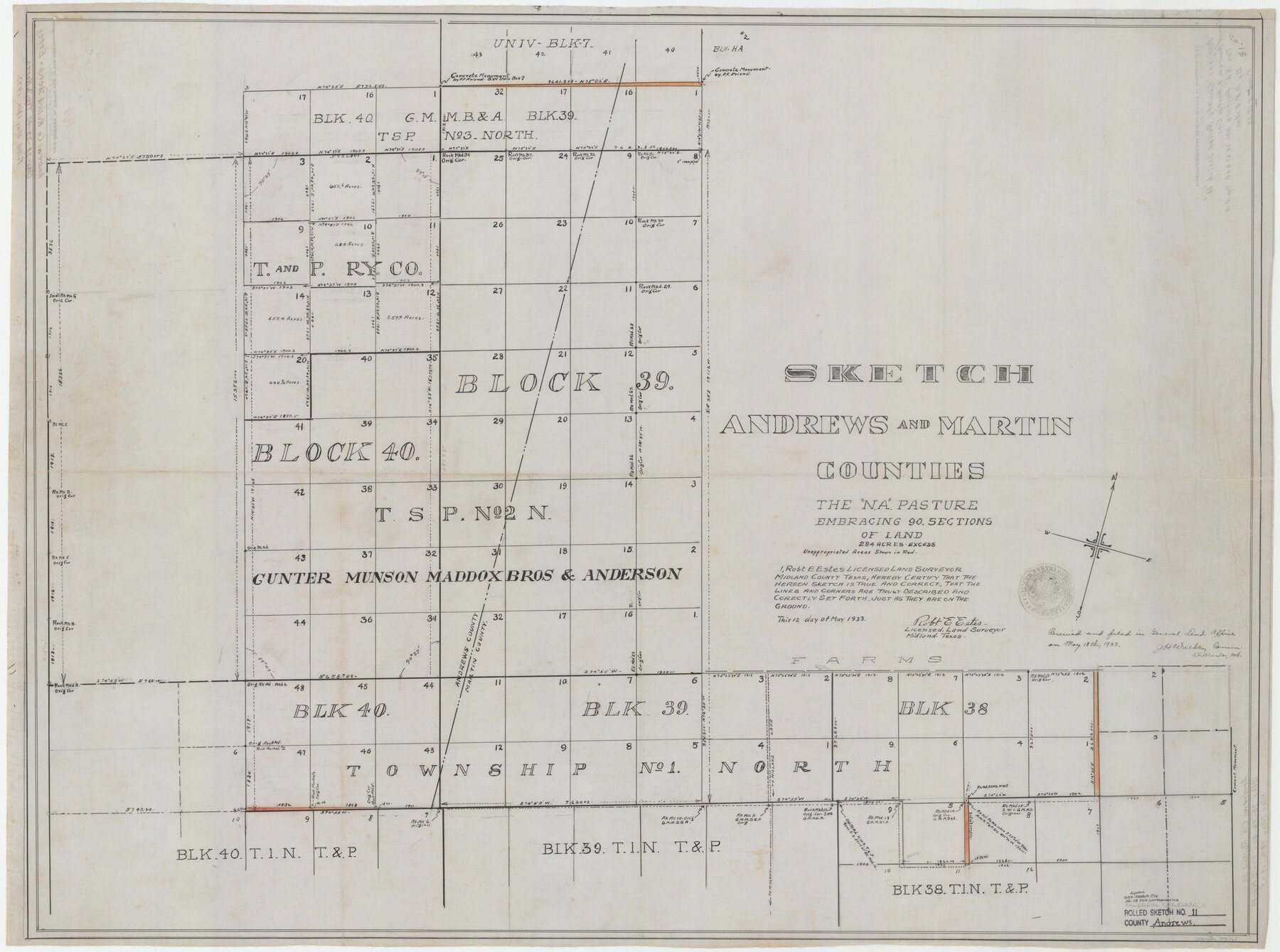
Andrews County Rolled Sketch 11
Sketch - Andrews and Martin Counties - The "N.A." Pasture embracing 90 sections of land - 284 acres excess
-
Map/Doc
77161
-
Collection
General Map Collection
-
Object Dates
1933/5/12 (Creation Date)
1933/5/18 (File Date)
-
People and Organizations
Robt. E. Estes (Surveyor/Engineer)
J.H. Walker (GLO Commissioner)
C.F. Blucher (GLO Clerk)
-
Counties
Andrews Martin
-
Subjects
Surveying Rolled Sketch
-
Height x Width
28.0 x 37.7 inches
71.1 x 95.8 cm
-
Medium
linen, manuscript
-
Comments
See Andrews County Sketch File 19 (12912) for related correspondence
Related maps
Andrews County Sketch File 19

Print $12.00
- Digital $50.00
Andrews County Sketch File 19
Size 14.3 x 8.8 inches
Map/Doc 12912
Andrews County Rolled Sketch 11A

Print $20.00
- Digital $50.00
Andrews County Rolled Sketch 11A
1933
Size 28.1 x 37.4 inches
Map/Doc 77162
Part of: General Map Collection
Dimmit County Rolled Sketch 9

Print $20.00
- Digital $50.00
Dimmit County Rolled Sketch 9
1941
Size 37.8 x 39.3 inches
Map/Doc 8796
International boundary between the United States and Mexico in the Rio Grande and Colorado River delineated in accordance with the Treaty of November 23, 1970 - Volume 2

International boundary between the United States and Mexico in the Rio Grande and Colorado River delineated in accordance with the Treaty of November 23, 1970 - Volume 2
1974
Size 25.0 x 35.2 inches
Map/Doc 7641
Midland County Sketch File D

Print $42.00
- Digital $50.00
Midland County Sketch File D
1901
Size 32.6 x 18.4 inches
Map/Doc 12089
Panola County Working Sketch 5

Print $20.00
- Digital $50.00
Panola County Working Sketch 5
1940
Map/Doc 71414
[Surveyor's certificate by James Howlet, District Surveyor]
![318, [Surveyor's certificate by James Howlet, District Surveyor], General Map Collection](https://historictexasmaps.com/wmedia_w700/maps/318.tif.jpg)
Print $2.00
- Digital $50.00
[Surveyor's certificate by James Howlet, District Surveyor]
Size 6.1 x 8.0 inches
Map/Doc 318
Dawson County Working Sketch 14

Print $20.00
- Digital $50.00
Dawson County Working Sketch 14
1952
Size 15.5 x 12.8 inches
Map/Doc 68558
Panola County

Print $20.00
- Digital $50.00
Panola County
1947
Size 40.8 x 40.3 inches
Map/Doc 66969
Montgomery County Working Sketch 36

Print $20.00
- Digital $50.00
Montgomery County Working Sketch 36
1953
Size 34.6 x 34.5 inches
Map/Doc 71143
Sketch of a portion of the Texas Coast showing the relative positions of different harbours with the interior Military Posts, and the roads communicating with them, also two new routes from Black Point and Lamar to San Antonio

Print $20.00
- Digital $50.00
Sketch of a portion of the Texas Coast showing the relative positions of different harbours with the interior Military Posts, and the roads communicating with them, also two new routes from Black Point and Lamar to San Antonio
1855
Size 27.5 x 18.2 inches
Map/Doc 72708
Montgomery County Working Sketch 75

Print $40.00
- Digital $50.00
Montgomery County Working Sketch 75
1986
Size 30.9 x 82.8 inches
Map/Doc 71182
Sutton County Working Sketch 2

Print $20.00
- Digital $50.00
Sutton County Working Sketch 2
1968
Size 31.2 x 29.3 inches
Map/Doc 62345
Galveston County

Print $40.00
- Digital $50.00
Galveston County
1939
Size 44.0 x 55.5 inches
Map/Doc 73155
You may also like
[PSL Block B1 and T. & P. Blocks 45 and 46, Township 1N]
![91967, [PSL Block B1 and T. & P. Blocks 45 and 46, Township 1N], Twichell Survey Records](https://historictexasmaps.com/wmedia_w700/maps/91967-1.tif.jpg)
Print $20.00
- Digital $50.00
[PSL Block B1 and T. & P. Blocks 45 and 46, Township 1N]
Size 40.8 x 10.6 inches
Map/Doc 91967
Right-of-Way and Track Map, Texas State Railroad operated by the T. and N. O. R.R. Co.

Print $40.00
- Digital $50.00
Right-of-Way and Track Map, Texas State Railroad operated by the T. and N. O. R.R. Co.
1917
Size 24.8 x 56.3 inches
Map/Doc 64173
[The S.K. Ry. of Texas, State Line to Pecos, Reeves Co., Texas]
![64162, [The S.K. Ry. of Texas, State Line to Pecos, Reeves Co., Texas], General Map Collection](https://historictexasmaps.com/wmedia_w700/maps/64162.tif.jpg)
Print $40.00
- Digital $50.00
[The S.K. Ry. of Texas, State Line to Pecos, Reeves Co., Texas]
1910
Size 19.8 x 120.7 inches
Map/Doc 64162

Travels to the source of the Missouri River and across the American Continent to the Pacific Ocean - Vol. 2

Travels to the source of the Missouri River and across the American Continent to the Pacific Ocean - Vol. 2
1815
Map/Doc 97413
[Blocks S1, O6, O, A1, A2, A3, A4, JK, JK2, JK4, and JD]
![90658, [Blocks S1, O6, O, A1, A2, A3, A4, JK, JK2, JK4, and JD], Twichell Survey Records](https://historictexasmaps.com/wmedia_w700/maps/90658-1.tif.jpg)
Print $20.00
- Digital $50.00
[Blocks S1, O6, O, A1, A2, A3, A4, JK, JK2, JK4, and JD]
Size 20.3 x 21.7 inches
Map/Doc 90658
Flight Mission No. CRC-3R, Frame 11, Chambers County

Print $20.00
- Digital $50.00
Flight Mission No. CRC-3R, Frame 11, Chambers County
1956
Size 18.7 x 22.4 inches
Map/Doc 84785
Township 1 South Range 11 West, South Western District, Louisiana

Print $20.00
- Digital $50.00
Township 1 South Range 11 West, South Western District, Louisiana
1881
Size 19.7 x 24.8 inches
Map/Doc 65879
San Patricio County Boundary File 76

Print $25.00
- Digital $50.00
San Patricio County Boundary File 76
Size 9.2 x 7.6 inches
Map/Doc 58563
Chambers County Sketch File 2

Print $8.00
- Digital $50.00
Chambers County Sketch File 2
Size 13.4 x 10.5 inches
Map/Doc 17518
San Patricio County Working Sketch 13

Print $20.00
- Digital $50.00
San Patricio County Working Sketch 13
1949
Size 38.8 x 38.6 inches
Map/Doc 63775
Travis County Sketch File 77

Print $26.00
- Digital $50.00
Travis County Sketch File 77
2004
Size 11.0 x 8.5 inches
Map/Doc 83254