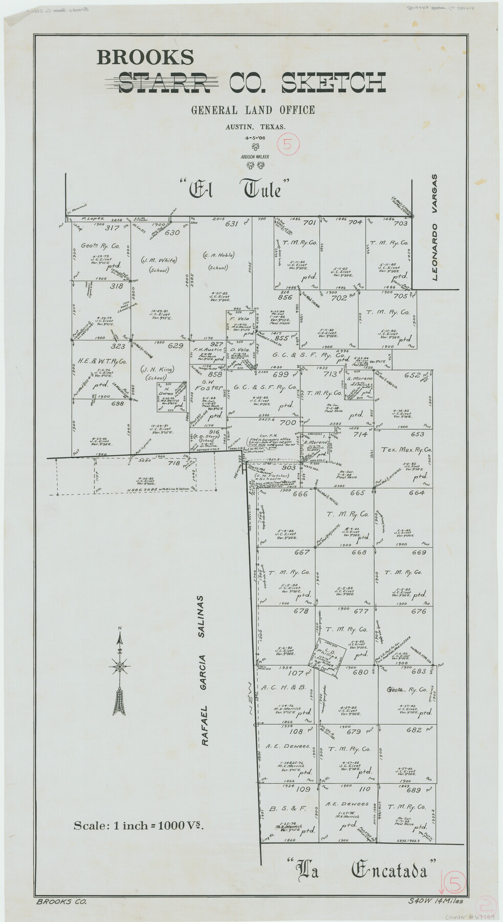
Brooks County Working Sketch 5
-
Map/Doc
67789
-
Collection
General Map Collection
-
Object Dates
4/5/1906 (Creation Date)
-
People and Organizations
Addison Walker (Draftsman)
-
Counties
Brooks
-
Subjects
Surveying Working Sketch
-
Height x Width
29.8 x 16.3 inches
75.7 x 41.4 cm
-
Scale
1" = 1000 varas
Part of: General Map Collection
Gaines County Rolled Sketch 20

Print $20.00
- Digital $50.00
Gaines County Rolled Sketch 20
1955
Size 30.1 x 37.2 inches
Map/Doc 5936
Eastham State Farm - Houston, Walker Counties and Ferguson State Farm, Madison County

Print $20.00
- Digital $50.00
Eastham State Farm - Houston, Walker Counties and Ferguson State Farm, Madison County
Size 27.7 x 40.3 inches
Map/Doc 62975
Pecos County Sketch File 71

Print $8.00
- Digital $50.00
Pecos County Sketch File 71
1936
Size 11.2 x 8.7 inches
Map/Doc 33872
Map of Hays County, Texas

Print $20.00
- Digital $50.00
Map of Hays County, Texas
1880
Size 41.8 x 35.8 inches
Map/Doc 16848
Zavala County Working Sketch 15

Print $20.00
- Digital $50.00
Zavala County Working Sketch 15
1977
Size 27.8 x 23.9 inches
Map/Doc 62090
Orange County Working Sketch 41

Print $20.00
- Digital $50.00
Orange County Working Sketch 41
1979
Size 28.0 x 18.2 inches
Map/Doc 71373
Brewster County Rolled Sketch 18B

Print $20.00
- Digital $50.00
Brewster County Rolled Sketch 18B
1906
Size 16.2 x 18.1 inches
Map/Doc 5197
Map of Comanche County

Print $40.00
- Digital $50.00
Map of Comanche County
1895
Size 47.5 x 50.0 inches
Map/Doc 4735
Map of the International and Great Northern Railroad between Austin and San Antonio, Texas

Print $40.00
- Digital $50.00
Map of the International and Great Northern Railroad between Austin and San Antonio, Texas
1881
Size 43.2 x 96.0 inches
Map/Doc 64777
Flight Mission No. DAG-21K, Frame 118, Matagorda County

Print $20.00
- Digital $50.00
Flight Mission No. DAG-21K, Frame 118, Matagorda County
1952
Size 17.5 x 16.1 inches
Map/Doc 86442
[Surveys along the San Jacinto River]
![62, [Surveys along the San Jacinto River], General Map Collection](https://historictexasmaps.com/wmedia_w700/maps/62.tif.jpg)
Print $3.00
- Digital $50.00
[Surveys along the San Jacinto River]
1841
Size 10.7 x 14.5 inches
Map/Doc 62
Aransas County NRC Article 33.136 Location Key Sheet

Print $20.00
- Digital $50.00
Aransas County NRC Article 33.136 Location Key Sheet
1971
Size 27.0 x 23.0 inches
Map/Doc 88769
You may also like
Trinity County Sketch File 25

Print $20.00
- Digital $50.00
Trinity County Sketch File 25
Size 19.5 x 37.3 inches
Map/Doc 12487
Fannin County Sketch File 6

Print $20.00
- Digital $50.00
Fannin County Sketch File 6
1857
Size 17.0 x 14.5 inches
Map/Doc 11469
McMullen County Sketch File 29

Print $20.00
- Digital $50.00
McMullen County Sketch File 29
1883
Size 35.8 x 15.4 inches
Map/Doc 12062
Chambers County Sketch File 4b

Print $27.00
- Digital $50.00
Chambers County Sketch File 4b
1950
Size 8.6 x 14.2 inches
Map/Doc 17530
Map of Fisher and Miller's Colony made from the records in the Office of the District Surveyor of Bexar comprising also all the recent surveys

Print $20.00
- Digital $50.00
Map of Fisher and Miller's Colony made from the records in the Office of the District Surveyor of Bexar comprising also all the recent surveys
1855
Size 27.2 x 39.6 inches
Map/Doc 82026
[Blocks A, RG, O, B and 11]
![92861, [Blocks A, RG, O, B and 11], Twichell Survey Records](https://historictexasmaps.com/wmedia_w700/maps/92861-1.tif.jpg)
Print $20.00
- Digital $50.00
[Blocks A, RG, O, B and 11]
Size 21.0 x 18.1 inches
Map/Doc 92861
Borden County, Texas

Print $20.00
- Digital $50.00
Borden County, Texas
1887
Size 19.9 x 18.3 inches
Map/Doc 596
Denton County Sketch File 37

Print $24.00
- Digital $50.00
Denton County Sketch File 37
1932
Size 11.5 x 8.9 inches
Map/Doc 20776
Leon County Sketch File 11a

Print $4.00
- Digital $50.00
Leon County Sketch File 11a
Size 9.7 x 8.7 inches
Map/Doc 29763
Hartley County

Print $40.00
- Digital $50.00
Hartley County
1925
Size 41.9 x 52.1 inches
Map/Doc 1851
Texas showing counties, cities, towns, villages and post offices, railways with stations and distances between stations

Print $40.00
- Digital $50.00
Texas showing counties, cities, towns, villages and post offices, railways with stations and distances between stations
1940
Size 45.6 x 49.4 inches
Map/Doc 4335
Map and Profile No. 1 from the Red River to the Rio Grande; from explorations and surveys made under the direction of the Hon. Jefferson Davis, Secretary of War by Captain John Pope, Corps. Topl Engrs.

Print $40.00
- Digital $50.00
Map and Profile No. 1 from the Red River to the Rio Grande; from explorations and surveys made under the direction of the Hon. Jefferson Davis, Secretary of War by Captain John Pope, Corps. Topl Engrs.
Size 30.2 x 59.9 inches
Map/Doc 95176