Orange County Sketch File 31
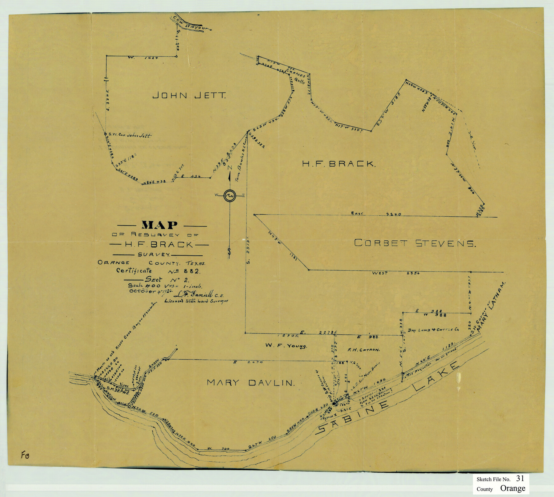
Map of resurvey of H.F. Brack survey, Orange County, Texas
- 
                          Map/Doc
12125
 - 
                            Collection
General Map Collection
 - 
                            Object Dates
10/4/1926 (Creation Date)
11/3/1926 (File Date)
 - 
                            People and Organizations
L.F. Daniell (Surveyor/Engineer)
 - 
                            Counties
Orange
 - 
                            Subjects
Surveying Sketch File
 - 
                            Height x Width
17.9 x 20.0 inches
45.5 x 50.8 cm
 - 
                            Medium
paper, manuscript
 - 
                            Scale
1" = 400 varas
 - 
                            Features
Cow Bayou
Crane's Gully
River Cove Bayou
Sabine Lake
 
Part of: General Map Collection
            Flight Mission No. BRE-1P, Frame 95, Nueces County


                                            Print $20.00                    
                                             -                         Digital $50.00                                    
                Flight Mission No. BRE-1P, Frame 95, Nueces County
1956
Size 18.4 x 22.2 inches
                                Map/Doc 86666
            
            No. 3 Chart of Channel connecting Corpus Christi Bay with Aransas Bay, Texas


                                            Print $20.00                    
                                             -                         Digital $50.00                                    
                No. 3 Chart of Channel connecting Corpus Christi Bay with Aransas Bay, Texas
1878
Size 18.4 x 28.0 inches
                                Map/Doc 72775
            
            Jefferson County Aerial Photograph Index Sheet 2


                                            Print $20.00                    
                                             -                         Digital $50.00                                    
                Jefferson County Aerial Photograph Index Sheet 2
1953
Size 23.4 x 17.0 inches
                                Map/Doc 83708
            
            Mason County Sketch File 19


                                            Print $20.00                    
                                             -                         Digital $50.00                                    
                Mason County Sketch File 19
1901
Size 19.1 x 20.9 inches
                                Map/Doc 12036
            
            Van Zandt County Sketch File 26


                                            Print $4.00                    
                                             -                         Digital $50.00                                    
                Van Zandt County Sketch File 26
1858
Size 6.7 x 7.9 inches
                                Map/Doc 39445
            
            Survey and Location of the Corpus Christi & Rio Grande Railway Under Charter of May 24th 1873


                                            Print $40.00                    
                                             -                         Digital $50.00                                    
                Survey and Location of the Corpus Christi & Rio Grande Railway Under Charter of May 24th 1873
1874
Size 12.5 x 58.7 inches
                                Map/Doc 64092
            
            Bowie County Sketch File 6e


                                            Print $4.00                    
                                             -                         Digital $50.00                                    
                Bowie County Sketch File 6e
1927
Size 11.2 x 8.4 inches
                                Map/Doc 14852
            
            Medina County Working Sketch 24


                                            Print $20.00                    
                                             -                         Digital $50.00                                    
                Medina County Working Sketch 24
1984
Size 26.1 x 36.7 inches
                                Map/Doc 70939
            
            Trinity River, Cooks Ferry Sheet


                                            Print $40.00                    
                                             -                         Digital $50.00                                    
                Trinity River, Cooks Ferry Sheet
1926
Size 36.5 x 56.2 inches
                                Map/Doc 65215
            
            Montague County Working Sketch 19


                                            Print $20.00                    
                                             -                         Digital $50.00                                    
                Montague County Working Sketch 19
1952
Size 26.4 x 21.5 inches
                                Map/Doc 71085
            
            Flight Mission No. DQN-2K, Frame 29, Calhoun County


                                            Print $20.00                    
                                             -                         Digital $50.00                                    
                Flight Mission No. DQN-2K, Frame 29, Calhoun County
1953
Size 18.7 x 22.3 inches
                                Map/Doc 84236
            
            El Paso County Sketch File 26


                                            Print $20.00                    
                                             -                         Digital $50.00                                    
                El Paso County Sketch File 26
Size 24.8 x 21.9 inches
                                Map/Doc 11457
            You may also like
            Texas Panhandle East Boundary Line


                                            Print $20.00                    
                                             -                         Digital $50.00                                    
                Texas Panhandle East Boundary Line
1898
Size 32.1 x 8.8 inches
                                Map/Doc 1700
            
            Lee County Working Sketch 16


                                            Print $20.00                    
                                             -                         Digital $50.00                                    
                Lee County Working Sketch 16
1982
Size 20.5 x 13.5 inches
                                Map/Doc 70395
            
            Cottle County Sketch File 6


                                            Print $20.00                    
                                             -                         Digital $50.00                                    
                Cottle County Sketch File 6
1883
Size 20.3 x 29.8 inches
                                Map/Doc 11190
            
            Brewster County Rolled Sketch 60


                                            Print $20.00                    
                                             -                         Digital $50.00                                    
                Brewster County Rolled Sketch 60
Size 25.0 x 37.5 inches
                                Map/Doc 8484
            
            Callahan County Sketch File 3


                                            Print $40.00                    
                                             -                         Digital $50.00                                    
                Callahan County Sketch File 3
1860
Size 17.4 x 13.8 inches
                                Map/Doc 35857
            
            Jefferson County NRC Article 33.136 Sketch 12


                                            Print $22.00                    
                                             -                         Digital $50.00                                    
                Jefferson County NRC Article 33.136 Sketch 12
2017
Size 24.0 x 36.0 inches
                                Map/Doc 95055
            
            [Gulf Coast of Texas]


                                            Print $20.00                    
                                             -                         Digital $50.00                                    
                [Gulf Coast of Texas]
1881
Size 28.6 x 18.2 inches
                                Map/Doc 72702
            
            Starr County Sketch File 20a


                                            Print $12.00                    
                                             -                         Digital $50.00                                    
                Starr County Sketch File 20a
1892
Size 14.3 x 8.8 inches
                                Map/Doc 36883
            
            Fayette County Working Sketch 10


                                            Print $20.00                    
                                             -                         Digital $50.00                                    
                Fayette County Working Sketch 10
1985
Size 27.1 x 38.5 inches
                                Map/Doc 69174
            
            Tom Green County Sketch File 50


                                            Print $20.00                    
                                             -                         Digital $50.00                                    
                Tom Green County Sketch File 50
1884
Size 25.4 x 34.5 inches
                                Map/Doc 12442
            
            Baylor County Sketch File A


                                            Print $6.00                    
                                             -                         Digital $50.00                                    
                Baylor County Sketch File A
Size 7.5 x 9.2 inches
                                Map/Doc 14072
            
            Hall County Sketch File 4


                                            Print $6.00                    
                                             -                         Digital $50.00                                    
                Hall County Sketch File 4
Size 14.2 x 9.3 inches
                                Map/Doc 24800