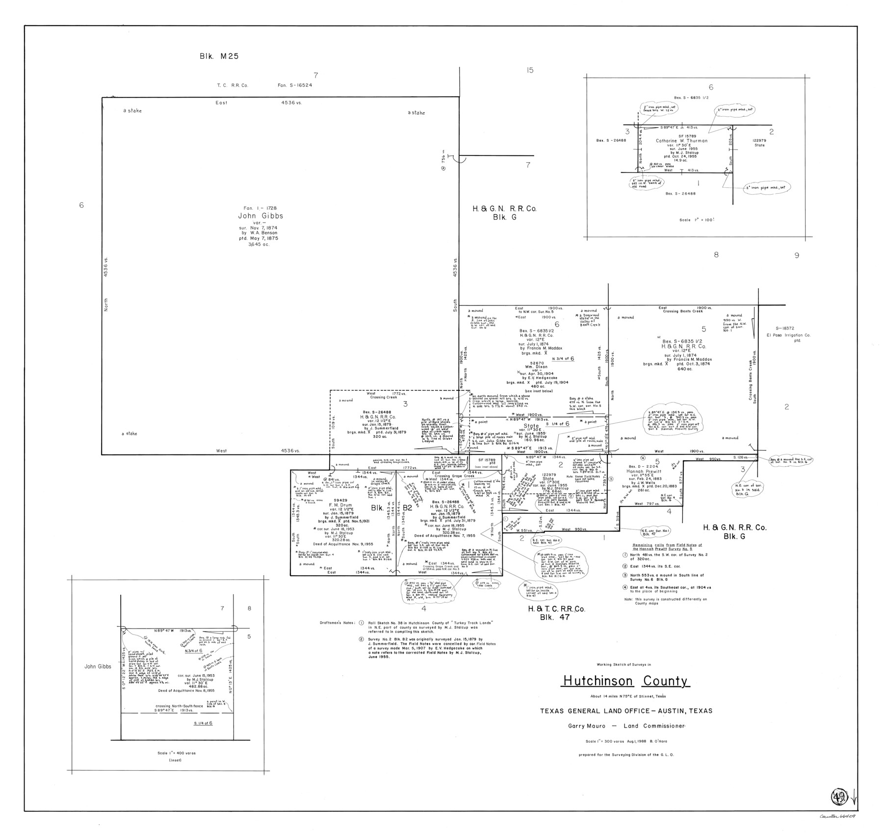
Hutchinson County Working Sketch 49
-
Map/Doc
66409
-
Collection
General Map Collection
-
Object Dates
8/1/1988 (Creation Date)
-
People and Organizations
Bill O'Hara (Draftsman)
-
Counties
Hutchinson
-
Subjects
Surveying Working Sketch
-
Height x Width
35.2 x 37.3 inches
89.4 x 94.7 cm
-
Scale
1" = 300 varas
Part of: General Map Collection
Flight Mission No. CRC-4R, Frame 72, Chambers County

Print $20.00
- Digital $50.00
Flight Mission No. CRC-4R, Frame 72, Chambers County
1956
Size 18.8 x 22.4 inches
Map/Doc 84876
Brazoria County Rolled Sketch 25B

Print $261.00
- Digital $50.00
Brazoria County Rolled Sketch 25B
Size 28.0 x 15.8 inches
Map/Doc 42752
Morris County Rolled Sketch 2A

Print $20.00
- Digital $50.00
Morris County Rolled Sketch 2A
Size 24.2 x 19.1 inches
Map/Doc 10247
Duval County Boundary File 4

Print $40.00
- Digital $50.00
Duval County Boundary File 4
Size 39.5 x 13.7 inches
Map/Doc 52767
Yoakum County

Print $20.00
- Digital $50.00
Yoakum County
1902
Size 46.1 x 36.6 inches
Map/Doc 63138
Morris County Rolled Sketch 2A

Print $20.00
- Digital $50.00
Morris County Rolled Sketch 2A
Size 24.0 x 18.8 inches
Map/Doc 10228
DeWitt County Sketch File 8

Print $4.00
- Digital $50.00
DeWitt County Sketch File 8
1876
Size 8.5 x 5.2 inches
Map/Doc 20818
Main Line Routes of the Santa Fe Lines

Main Line Routes of the Santa Fe Lines
Size 12.1 x 18.1 inches
Map/Doc 94157
Armstrong County Rolled Sketch B1

Print $20.00
- Digital $50.00
Armstrong County Rolled Sketch B1
1903
Size 25.8 x 37.8 inches
Map/Doc 5085
Val Verde County Sketch File 24

Print $20.00
- Digital $50.00
Val Verde County Sketch File 24
Size 22.5 x 34.3 inches
Map/Doc 76759
[Section of] Carte du Mexique et de la Nouvelle Espagne
![97485, [Section of] Carte du Mexique et de la Nouvelle Espagne, General Map Collection](https://historictexasmaps.com/wmedia_w700/maps/97485.tif.jpg)
[Section of] Carte du Mexique et de la Nouvelle Espagne
1779
Size 14.0 x 16.7 inches
Map/Doc 97485
Kleberg County Rolled Sketch 12

Print $20.00
- Digital $50.00
Kleberg County Rolled Sketch 12
1994
Size 25.8 x 36.6 inches
Map/Doc 6553
You may also like
Kleberg County Rolled Sketch 10-13

Print $20.00
- Digital $50.00
Kleberg County Rolled Sketch 10-13
1952
Size 37.0 x 32.5 inches
Map/Doc 9391
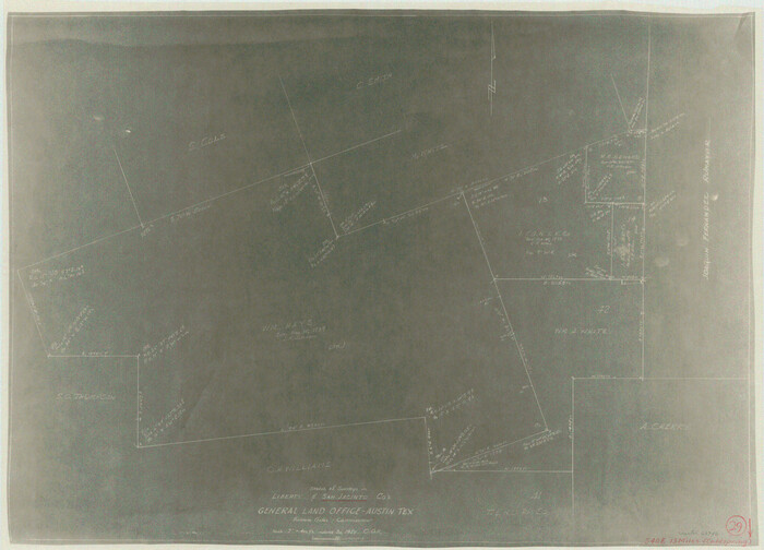
San Jacinto County Working Sketch 29
Print $20.00
- Digital $50.00
San Jacinto County Working Sketch 29
1950
Size 17.6 x 24.4 inches
Map/Doc 63742

Kenedy County Rolled Sketch 12

Print $20.00
- Digital $50.00
Kenedy County Rolled Sketch 12
1944
Size 34.6 x 41.1 inches
Map/Doc 9333

Kerr County Working Sketch 23

Print $20.00
- Digital $50.00
Kerr County Working Sketch 23
1966
Size 33.4 x 41.0 inches
Map/Doc 70054
Houston County Working Sketch 23

Print $20.00
- Digital $50.00
Houston County Working Sketch 23
1983
Size 19.4 x 25.3 inches
Map/Doc 66253
Baylor County Sketch File A

Print $6.00
- Digital $50.00
Baylor County Sketch File A
Size 7.5 x 9.2 inches
Map/Doc 14072
Lipscomb County Boundary File 2

Print $6.00
- Digital $50.00
Lipscomb County Boundary File 2
Size 11.1 x 8.6 inches
Map/Doc 56315
Travis County

Print $40.00
- Digital $50.00
Travis County
1880
Size 62.1 x 50.2 inches
Map/Doc 87935
San Augustine County Working Sketch 1

Print $3.00
- Digital $50.00
San Augustine County Working Sketch 1
1906
Size 9.1 x 11.3 inches
Map/Doc 63688
Matagorda Light to Aransas Pass

Print $20.00
- Digital $50.00
Matagorda Light to Aransas Pass
1935
Size 35.1 x 44.2 inches
Map/Doc 73393