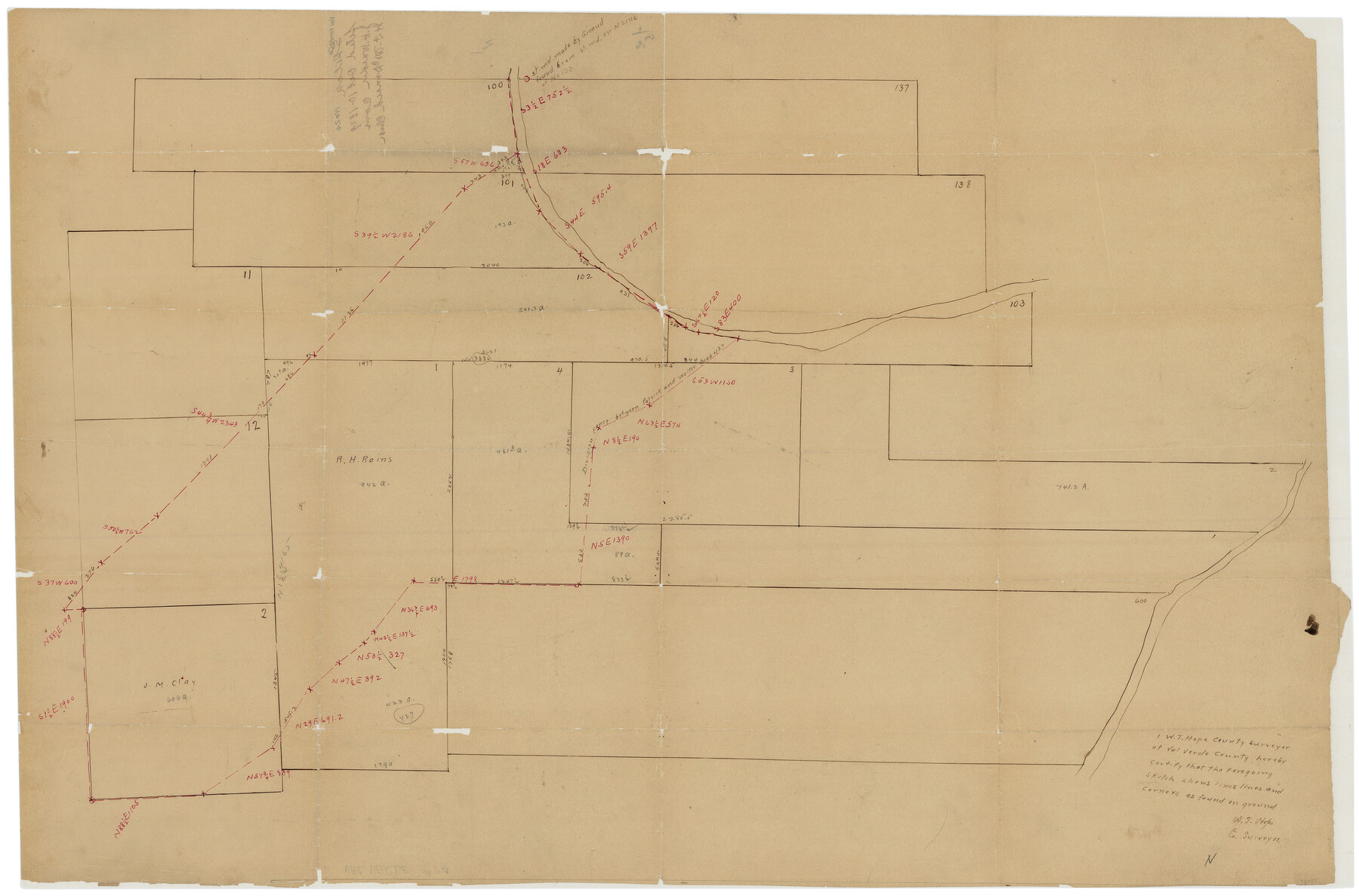
Val Verde County Sketch File 24
[Sketch of surveys east of the Pecos River northwest from Del Rio]
-
Map/Doc
76759
-
Collection
General Map Collection
-
Object Dates
10/10/1929 (File Date)
-
People and Organizations
W.T. Hope (Surveyor/Engineer)
-
Counties
Val Verde
-
Subjects
Surveying Sketch File
-
Height x Width
22.5 x 34.3 inches
57.2 x 87.1 cm
-
Medium
paper, manuscript
Part of: General Map Collection
Brewster County Rolled Sketch 15

Print $20.00
- Digital $50.00
Brewster County Rolled Sketch 15
1889
Size 32.8 x 26.4 inches
Map/Doc 5194
Orange County Sketch File 41

Print $40.00
- Digital $50.00
Orange County Sketch File 41
1918
Size 13.2 x 13.3 inches
Map/Doc 33381
McMullen County Sketch File 27a

Print $4.00
- Digital $50.00
McMullen County Sketch File 27a
Size 9.5 x 6.3 inches
Map/Doc 31390
Maps of Gulf Intracoastal Waterway, Texas - Sabine River to the Rio Grande and connecting waterways including ship channels

Print $20.00
- Digital $50.00
Maps of Gulf Intracoastal Waterway, Texas - Sabine River to the Rio Grande and connecting waterways including ship channels
1966
Size 14.6 x 22.3 inches
Map/Doc 61965
Belton and Stillhouse Hollow Reservoirs (Recto)

Belton and Stillhouse Hollow Reservoirs (Recto)
1972
Size 29.1 x 22.6 inches
Map/Doc 94172
Terrell County Rolled Sketch 48

Print $20.00
- Digital $50.00
Terrell County Rolled Sketch 48
1959
Size 20.5 x 22.3 inches
Map/Doc 7950
Map of the United States, Canada and a part of Mexico to illustrate Olney's school geography

Print $20.00
- Digital $50.00
Map of the United States, Canada and a part of Mexico to illustrate Olney's school geography
1844
Size 12.1 x 19.0 inches
Map/Doc 93537
Wilbarger County Sketch File A

Print $6.00
- Digital $50.00
Wilbarger County Sketch File A
Size 8.3 x 14.1 inches
Map/Doc 40231
Midland County Sketch File 5

Print $2.00
- Digital $50.00
Midland County Sketch File 5
Size 8.4 x 3.5 inches
Map/Doc 31575
[Surveys along the Lavaca River]
![25, [Surveys along the Lavaca River], General Map Collection](https://historictexasmaps.com/wmedia_w700/maps/25.tif.jpg)
Print $2.00
- Digital $50.00
[Surveys along the Lavaca River]
1833
Size 12.9 x 8.9 inches
Map/Doc 25
Texas Hill Country Trail Region

Texas Hill Country Trail Region
2017
Size 18.2 x 24.3 inches
Map/Doc 96871
Mills County Sketch File 22

Print $4.00
- Digital $50.00
Mills County Sketch File 22
1882
Size 9.8 x 8.0 inches
Map/Doc 31670
You may also like
Reagan County Rolled Sketch 11

Print $20.00
- Digital $50.00
Reagan County Rolled Sketch 11
1931
Size 20.2 x 39.3 inches
Map/Doc 7439
Flight Mission No. CUG-1P, Frame 106, Kleberg County

Print $20.00
- Digital $50.00
Flight Mission No. CUG-1P, Frame 106, Kleberg County
1956
Size 18.8 x 22.3 inches
Map/Doc 86156

Jasper County Working Sketch 16

Print $20.00
- Digital $50.00
Jasper County Working Sketch 16
1928
Size 13.7 x 14.3 inches
Map/Doc 66478
[Sketch showing Blocks B-11, O-18, P and Mc in case of Laneer vs. Bivens]
![91726, [Sketch showing Blocks B-11, O-18, P and Mc in case of Laneer vs. Bivens], Twichell Survey Records](https://historictexasmaps.com/wmedia_w700/maps/91726-1.tif.jpg)
Print $20.00
- Digital $50.00
[Sketch showing Blocks B-11, O-18, P and Mc in case of Laneer vs. Bivens]
Size 21.2 x 18.6 inches
Map/Doc 91726
Karnes County Sketch File 14

Print $6.00
- Digital $50.00
Karnes County Sketch File 14
1897
Size 9.7 x 6.2 inches
Map/Doc 28615
Brewster County Sketch File 38

Print $4.00
- Digital $50.00
Brewster County Sketch File 38
Size 12.1 x 8.9 inches
Map/Doc 16222
Matagorda County Rolled Sketch 36

Print $115.00
- Digital $50.00
Matagorda County Rolled Sketch 36
1944
Size 10.1 x 15.0 inches
Map/Doc 46747
Kinney County Working Sketch 47

Print $20.00
- Digital $50.00
Kinney County Working Sketch 47
1979
Size 40.5 x 39.1 inches
Map/Doc 70229
Map of Nacogdoches County

Print $40.00
- Digital $50.00
Map of Nacogdoches County
1846
Size 83.7 x 76.1 inches
Map/Doc 82243
Nueces County Sketch File 42

Print $24.00
- Digital $50.00
Nueces County Sketch File 42
1950
Size 11.0 x 8.6 inches
Map/Doc 32633
Upshur County Rolled Sketch 2

Print $20.00
- Digital $50.00
Upshur County Rolled Sketch 2
1954
Size 26.8 x 23.4 inches
Map/Doc 8061