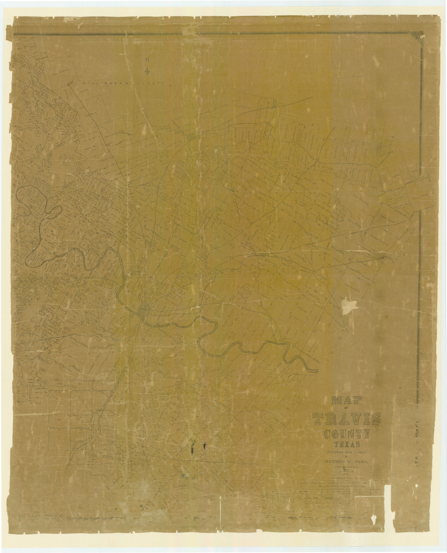
Travis County
-
Map/Doc
87935
-
Collection
General Map Collection
-
Object Dates
1880/3/30 (Creation Date)
-
People and Organizations
Reuben W. Ford (Compiler)
Reuben W. Ford (Draftsman)
August Gast & Co. (Lithographer)
-
Counties
Travis
-
Subjects
County
-
Height x Width
62.1 x 50.2 inches
157.7 x 127.5 cm
-
Comments
Digitally combined version of counter numbers 87934 and 87935.
Prints made at 88%. -
Features
Old Round Rock
Cypress Creek
Merriltown Post Office
Road to Hutto
Rice's Crossing
Road to Taylor
Lake Creek
Brushy Creek
Round Rock
New Round Rock
Jolleville [sic]
Running Brushy Creek
Dry Brushy Creek
J. P. Dodd's Post Office
Sandy Creek
Cherry Creek
Road to Georgetown
Newtown
Hutto Station
Cross Creek
Fiskville Post Office
Cottonwood Creek
Manor
Gilleland's Creek
Harris's Branch of Gilleland's Creek
Little Walrus Creek
Shoal Creek
Public Road to Round Rock
Public Road to Georgetown
Public Road to Georgetown or Round Rock
Whit's House
Spicewood Spring
Spicewood Spring
Colorado River
Bull Creek
Dessau Settlement
Conrad Ph[ ] Church
Phluegerville [sic]
Duval
[ ]lelands Creek
Oatman Post Office
Shring Creek
Austin
Miller
Chapman
Tinnin
Stone
Flour Mill [North of the Colorado River on Logan Vandaver Survey]
Webberville
Fredericksburg Road
Bee Creek
Spring Creek
Mount Bonell
Walnut Creek
Wilbarger Creek
Road to Hageye
Elgin
Elm Creek
Road to Rockdale
Cottonmouth Branch [of Onion Creek]
Town of Bagdad Post Office
Town of Taylor
Old San [Antonio Road]
Road to [Menifee?] City
Manchaca
Onion Creek Post Office
Church [on SW Corner of S. E. Slaughter Survey]
Bear Creek
Pilot Knob
Willow Creek
Cedar Creek
Road to Bastrop
Onion Creek
Thomas's Branch [of Colorado River]
St. Elmo Post Office
Williamson Creek
Slaughter Creek
Grape Creek
Part of: General Map Collection
Montgomery County Working Sketch 69

Print $20.00
- Digital $50.00
Montgomery County Working Sketch 69
1973
Size 27.3 x 37.7 inches
Map/Doc 71176
Township No. 2 South Range No. 20 West of the Indian Meridian

Print $20.00
- Digital $50.00
Township No. 2 South Range No. 20 West of the Indian Meridian
1875
Size 19.2 x 24.5 inches
Map/Doc 75180
Map of Kerr County

Print $40.00
- Digital $50.00
Map of Kerr County
1895
Size 39.7 x 48.9 inches
Map/Doc 5002
Terrell County Working Sketch 25

Print $40.00
- Digital $50.00
Terrell County Working Sketch 25
1942
Size 41.9 x 49.1 inches
Map/Doc 62175
El Paso County Rolled Sketch 59

Print $20.00
- Digital $50.00
El Paso County Rolled Sketch 59
1990
Size 34.5 x 36.0 inches
Map/Doc 8881
Duval County Sketch File 57

Print $14.00
- Digital $50.00
Duval County Sketch File 57
1939
Size 14.2 x 8.9 inches
Map/Doc 21418
Map of Harris County

Print $20.00
- Digital $50.00
Map of Harris County
1893
Size 26.6 x 34.4 inches
Map/Doc 65810
Flight Mission No. DQN-2K, Frame 158, Calhoun County

Print $20.00
- Digital $50.00
Flight Mission No. DQN-2K, Frame 158, Calhoun County
1953
Size 18.4 x 22.3 inches
Map/Doc 84320
Map of Galveston, Turtle & East Bays & Portion of the Gulf of Mexico in Chambers & Galveston Counties, Texas Showing Subdivision Thereof for Mineral Development

Print $40.00
- Digital $50.00
Map of Galveston, Turtle & East Bays & Portion of the Gulf of Mexico in Chambers & Galveston Counties, Texas Showing Subdivision Thereof for Mineral Development
1935
Size 43.6 x 51.1 inches
Map/Doc 78633
Parker County Sketch File 33

Print $4.00
- Digital $50.00
Parker County Sketch File 33
Size 10.6 x 7.9 inches
Map/Doc 33576
Bowie County Working Sketch Graphic Index

Print $20.00
- Digital $50.00
Bowie County Working Sketch Graphic Index
1933
Size 38.9 x 47.1 inches
Map/Doc 76470
Reagan County Sketch File 7

Print $6.00
- Digital $50.00
Reagan County Sketch File 7
1928
Size 11.2 x 8.7 inches
Map/Doc 34986
You may also like
Flight Mission No. DCL-4C, Frame 123, Kenedy County

Print $20.00
- Digital $50.00
Flight Mission No. DCL-4C, Frame 123, Kenedy County
1943
Size 18.6 x 22.3 inches
Map/Doc 85822
Red River County Working Sketch 2

Print $20.00
- Digital $50.00
Red River County Working Sketch 2
1918
Size 26.9 x 21.7 inches
Map/Doc 71985
[Surveys along the Red River and Capitol Lands]
![90738, [Surveys along the Red River and Capitol Lands], Twichell Survey Records](https://historictexasmaps.com/wmedia_w700/maps/90738-1.tif.jpg)
Print $20.00
- Digital $50.00
[Surveys along the Red River and Capitol Lands]
Size 24.8 x 39.7 inches
Map/Doc 90738
Flight Mission No. BRA-16M, Frame 84, Jefferson County

Print $20.00
- Digital $50.00
Flight Mission No. BRA-16M, Frame 84, Jefferson County
1953
Size 18.6 x 22.1 inches
Map/Doc 85696
Donley County Sketch File B11

Print $4.00
- Digital $50.00
Donley County Sketch File B11
1952
Size 11.5 x 9.0 inches
Map/Doc 21274
Tyler County Boundary File 1

Print $2.00
- Digital $50.00
Tyler County Boundary File 1
Size 14.2 x 8.8 inches
Map/Doc 59494
Hemphill County Working Sketch 10

Print $20.00
- Digital $50.00
Hemphill County Working Sketch 10
1965
Size 23.5 x 35.7 inches
Map/Doc 66105
Sutton County Working Sketch 57

Print $20.00
- Digital $50.00
Sutton County Working Sketch 57
1958
Size 37.7 x 32.9 inches
Map/Doc 62400
Upshur County Sketch File 3a

Print $2.00
- Digital $50.00
Upshur County Sketch File 3a
Size 6.5 x 7.1 inches
Map/Doc 38736
Throckmorton County Sketch File 7b

Print $4.00
- Digital $50.00
Throckmorton County Sketch File 7b
Size 13.0 x 6.5 inches
Map/Doc 38097
Brewster County Rolled Sketch 68

Print $20.00
- Digital $50.00
Brewster County Rolled Sketch 68
1940
Size 20.2 x 29.9 inches
Map/Doc 5234
Liberty County Sketch File 45

Print $4.00
- Digital $50.00
Liberty County Sketch File 45
Size 7.8 x 10.1 inches
Map/Doc 30003