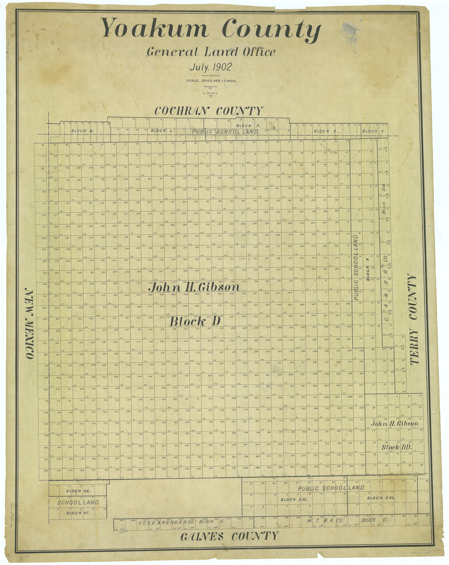
Yoakum County
-
Map/Doc
63138
-
Collection
General Map Collection
-
Object Dates
1902 (Creation Date)
-
People and Organizations
Texas General Land Office (Publisher)
-
Counties
Yoakum
-
Subjects
County
-
Height x Width
46.1 x 36.6 inches
117.1 x 93.0 cm
-
Comments
Traced in 1903 by Jelinek.
Part of: General Map Collection

Trinity River, Levee Improvement Districts, Widths of Floodways/Pilot Grove Creek and East Fork Trinity River

Print $6.00
- Digital $50.00
Trinity River, Levee Improvement Districts, Widths of Floodways/Pilot Grove Creek and East Fork Trinity River
1920
Size 33.0 x 17.1 inches
Map/Doc 65259
Hockley County Sketch File 19b

Print $28.00
- Digital $50.00
Hockley County Sketch File 19b
Size 11.3 x 8.8 inches
Map/Doc 26555
Sabine County Working Sketch 3

Print $3.00
- Digital $50.00
Sabine County Working Sketch 3
1911
Size 10.8 x 15.7 inches
Map/Doc 63674
[Sketch for Mineral Application 18874 - Pecos River Bed, W. J. Bonner]
![65584, [Sketch for Mineral Application 18874 - Pecos River Bed, W. J. Bonner], General Map Collection](https://historictexasmaps.com/wmedia_w700/maps/65584.tif.jpg)
Print $20.00
- Digital $50.00
[Sketch for Mineral Application 18874 - Pecos River Bed, W. J. Bonner]
1927
Size 37.5 x 31.6 inches
Map/Doc 65584
Harrison County Sketch File 1

Print $26.00
- Digital $50.00
Harrison County Sketch File 1
1849
Size 8.2 x 7.7 inches
Map/Doc 26030
Nautical Chart 152-SC - Galveston Bay, Texas

Print $20.00
- Digital $50.00
Nautical Chart 152-SC - Galveston Bay, Texas
1972
Size 15.2 x 33.5 inches
Map/Doc 69891
Flight Mission No. CRC-3R, Frame 33, Chambers County

Print $20.00
- Digital $50.00
Flight Mission No. CRC-3R, Frame 33, Chambers County
1956
Size 18.6 x 22.4 inches
Map/Doc 84806
Map of Padre Island Showing Location of Zoning Districts

Print $20.00
- Digital $50.00
Map of Padre Island Showing Location of Zoning Districts
1971
Size 26.2 x 18.5 inches
Map/Doc 4811
Eastland County Working Sketch 36

Print $20.00
- Digital $50.00
Eastland County Working Sketch 36
1963
Size 24.0 x 40.0 inches
Map/Doc 68817
Real County Sketch File 16

Print $20.00
- Digital $50.00
Real County Sketch File 16
1934
Size 23.1 x 22.1 inches
Map/Doc 12234
Dallas County Boundary File 6c

Print $4.00
- Digital $50.00
Dallas County Boundary File 6c
Size 14.0 x 8.6 inches
Map/Doc 52227
You may also like
Lynn County Boundary File 7

Print $10.00
- Digital $50.00
Lynn County Boundary File 7
Size 11.5 x 8.8 inches
Map/Doc 56642
McMullen and McGloin Empresario Colony. August 16, 1828

Print $20.00
McMullen and McGloin Empresario Colony. August 16, 1828
2020
Size 17.6 x 21.7 inches
Map/Doc 95998
Flight Mission No. DIX-6P, Frame 186, Aransas County

Print $20.00
- Digital $50.00
Flight Mission No. DIX-6P, Frame 186, Aransas County
1956
Size 19.2 x 22.9 inches
Map/Doc 83848
McLennan County Boundary File 4

Print $12.00
- Digital $50.00
McLennan County Boundary File 4
Size 8.8 x 7.5 inches
Map/Doc 56973
Llano County Working Sketch 4

Print $40.00
- Digital $50.00
Llano County Working Sketch 4
1954
Size 33.4 x 54.0 inches
Map/Doc 70622
Brooks County Sketch File 10

Print $2.00
- Digital $50.00
Brooks County Sketch File 10
1988
Size 14.4 x 9.0 inches
Map/Doc 16572
[Lgs. 209-212, 182, 183, 195-200 with notes]
![90159, [Lgs. 209-212, 182, 183, 195-200 with notes], Twichell Survey Records](https://historictexasmaps.com/wmedia_w700/maps/90159-1.tif.jpg)
Print $20.00
- Digital $50.00
[Lgs. 209-212, 182, 183, 195-200 with notes]
Size 18.7 x 15.6 inches
Map/Doc 90159
Hood County Sketch File 17

Print $4.00
- Digital $50.00
Hood County Sketch File 17
1860
Size 8.2 x 9.4 inches
Map/Doc 26599
Map of Upton County

Print $20.00
- Digital $50.00
Map of Upton County
1899
Size 46.0 x 40.2 inches
Map/Doc 63087
[Blueprint of unknown Block/Surveys]
![92139, [Blueprint of unknown Block/Surveys], Twichell Survey Records](https://historictexasmaps.com/wmedia_w700/maps/92139-1.tif.jpg)
Print $20.00
- Digital $50.00
[Blueprint of unknown Block/Surveys]
Size 24.7 x 26.8 inches
Map/Doc 92139
Flight Mission No. CRC-4R, Frame 81, Chambers County

Print $20.00
- Digital $50.00
Flight Mission No. CRC-4R, Frame 81, Chambers County
1956
Size 18.7 x 22.5 inches
Map/Doc 84885
Corpus Christi Bay, Texas

Print $40.00
- Digital $50.00
Corpus Christi Bay, Texas
1867
Size 33.0 x 48.7 inches
Map/Doc 73467