Liberty County Rolled Sketch H
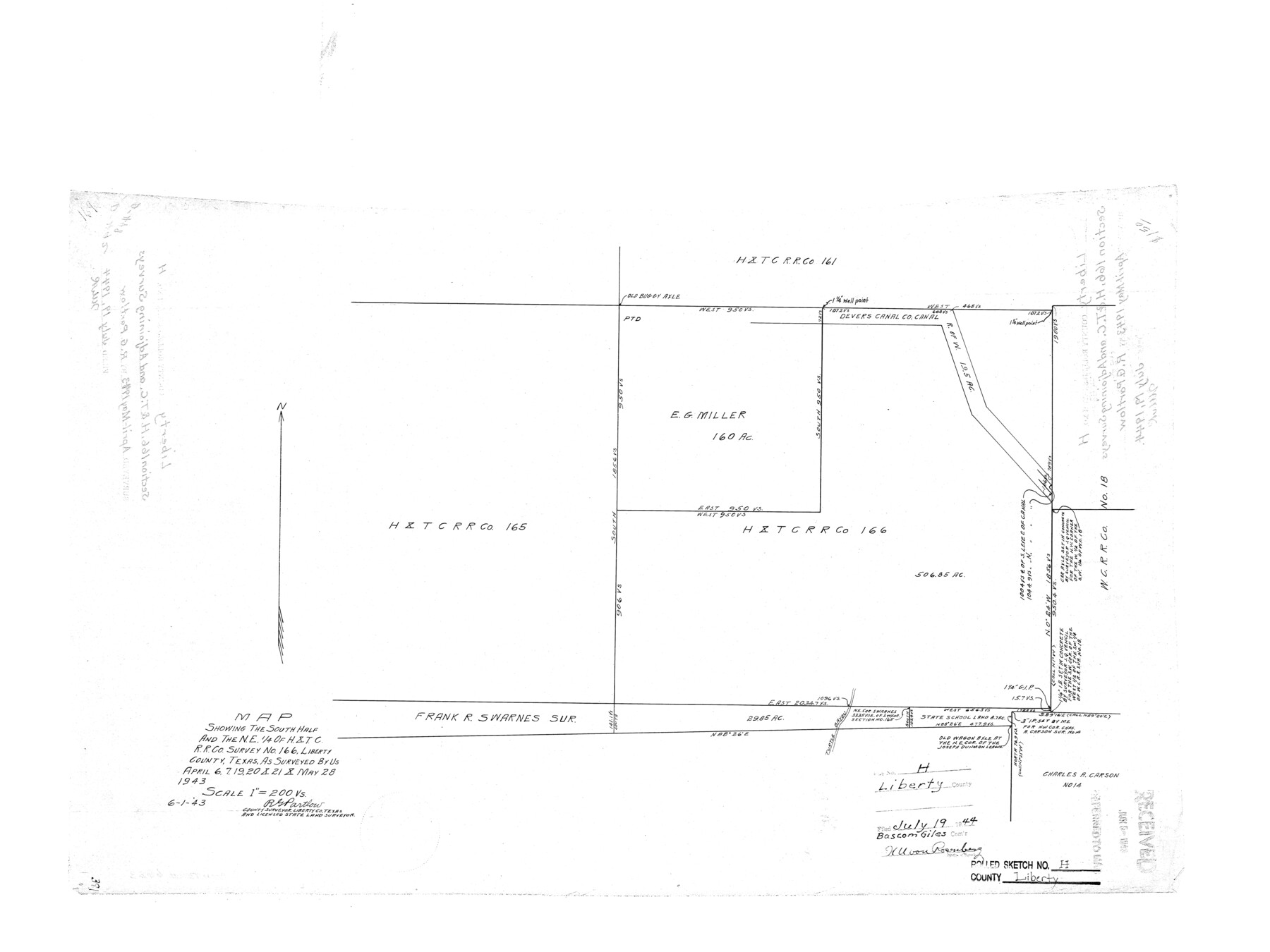
Map showing the south half and the NE 1/4 of H. & T. C. R.R. Co. survey no. 166
-
Map/Doc
6623
-
Collection
General Map Collection
-
Object Dates
1943/5/28 (Survey Date)
1944/7/19 (File Date)
1943/6/1 (Creation Date)
-
People and Organizations
R.G. Partlow (Surveyor/Engineer)
-
Counties
Liberty
-
Subjects
Surveying Rolled Sketch
-
Height x Width
22.2 x 29.6 inches
56.4 x 75.2 cm
-
Scale
1" = 200 varas
Part of: General Map Collection
Mason County Rolled Sketch 6

Print $20.00
- Digital $50.00
Mason County Rolled Sketch 6
Size 19.5 x 22.2 inches
Map/Doc 6678
San Augustine County

Print $20.00
- Digital $50.00
San Augustine County
1871
Size 20.7 x 14.2 inches
Map/Doc 4014
Map of San Saba County

Print $20.00
- Digital $50.00
Map of San Saba County
1858
Size 21.6 x 23.5 inches
Map/Doc 4019
Chambers County NRC Article 33.136 Location Key Sheet

Print $20.00
- Digital $50.00
Chambers County NRC Article 33.136 Location Key Sheet
1982
Size 27.0 x 22.0 inches
Map/Doc 87908
Coke County Sketch File 29

Print $20.00
- Digital $50.00
Coke County Sketch File 29
Size 10.9 x 21.8 inches
Map/Doc 11114
Harris County Sketch File D

Print $4.00
- Digital $50.00
Harris County Sketch File D
1860
Size 8.1 x 4.9 inches
Map/Doc 25313
Lamb County Working Sketch Graphic Index

Print $20.00
- Digital $50.00
Lamb County Working Sketch Graphic Index
1961
Size 43.8 x 34.1 inches
Map/Doc 76613
Gregg County Rolled Sketch 16

Print $20.00
- Digital $50.00
Gregg County Rolled Sketch 16
1942
Size 29.0 x 36.7 inches
Map/Doc 6038
Flight Mission No. CRK-7P, Frame 25, Refugio County

Print $20.00
- Digital $50.00
Flight Mission No. CRK-7P, Frame 25, Refugio County
1956
Size 18.6 x 22.3 inches
Map/Doc 86945
Anderson County Working Sketch 11a

Print $40.00
- Digital $50.00
Anderson County Working Sketch 11a
1933
Size 42.7 x 64.2 inches
Map/Doc 67011
Wise County Sketch File 19

Print $4.00
- Digital $50.00
Wise County Sketch File 19
1857
Size 11.0 x 8.2 inches
Map/Doc 40555
Midland County Working Sketch 2

Print $20.00
- Digital $50.00
Midland County Working Sketch 2
Size 40.4 x 25.2 inches
Map/Doc 70982
You may also like
Ellis County Working Sketch 3

Print $40.00
- Digital $50.00
Ellis County Working Sketch 3
1981
Size 39.1 x 50.0 inches
Map/Doc 69019
Cameron County

Print $20.00
- Digital $50.00
Cameron County
1913
Size 30.0 x 33.8 inches
Map/Doc 1793
Right of Way and Track Map Houston & Texas Central R.R. operated by the T. and N. O. R.R. Co., Fort Worth Branch

Print $40.00
- Digital $50.00
Right of Way and Track Map Houston & Texas Central R.R. operated by the T. and N. O. R.R. Co., Fort Worth Branch
1918
Size 30.7 x 56.4 inches
Map/Doc 64542
Johnson County Sketch File 5

Print $20.00
- Digital $50.00
Johnson County Sketch File 5
1874
Size 33.3 x 14.3 inches
Map/Doc 11890
Fort Bend County Working Sketch 2

Print $20.00
- Digital $50.00
Fort Bend County Working Sketch 2
1897
Size 18.3 x 28.4 inches
Map/Doc 69208
Flight Mission No. DQN-1K, Frame 142, Calhoun County

Print $20.00
- Digital $50.00
Flight Mission No. DQN-1K, Frame 142, Calhoun County
1953
Size 18.8 x 22.3 inches
Map/Doc 84205
Gulf of Mexico

Print $20.00
- Digital $50.00
Gulf of Mexico
1900
Size 18.4 x 28.1 inches
Map/Doc 72649
Terrell County Rolled Sketch 40

Print $20.00
- Digital $50.00
Terrell County Rolled Sketch 40
1943
Size 16.7 x 18.1 inches
Map/Doc 7944
Map Showing Location of Galveston, Harrisburg & San Antonio Railway

Print $40.00
- Digital $50.00
Map Showing Location of Galveston, Harrisburg & San Antonio Railway
1881
Size 17.4 x 59.3 inches
Map/Doc 64457
Texas 1973 Official Highway Travel Map

Texas 1973 Official Highway Travel Map
Size 28.2 x 36.3 inches
Map/Doc 94405
Childress Co.

Print $20.00
- Digital $50.00
Childress Co.
1978
Size 44.6 x 33.7 inches
Map/Doc 77237
Flight Mission No. CLL-3N, Frame 8, Willacy County

Print $20.00
- Digital $50.00
Flight Mission No. CLL-3N, Frame 8, Willacy County
1954
Size 18.5 x 22.2 inches
Map/Doc 87074