Coke County Sketch File 29
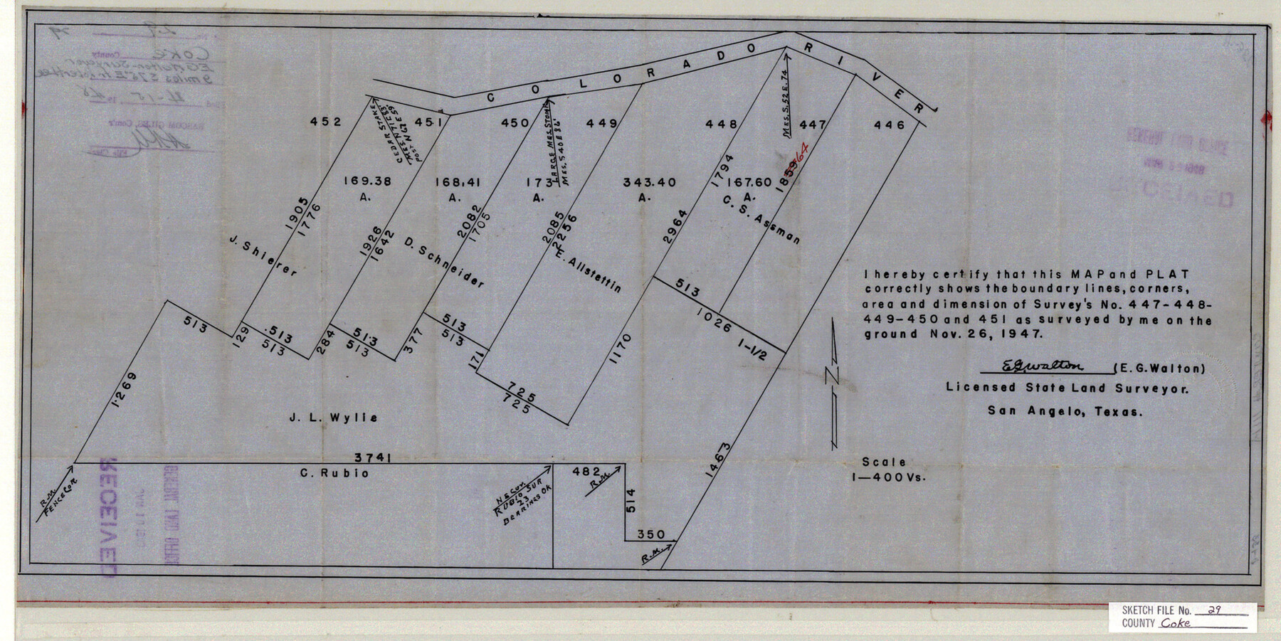
[Plat of surveys 447, 448, 449, 450, and 451 along Colorado River]
-
Map/Doc
11114
-
Collection
General Map Collection
-
Object Dates
1948/4/15 (File Date)
1947/11/26 (Survey Date)
-
People and Organizations
E.G. Walton (Surveyor/Engineer)
-
Counties
Coke
-
Subjects
Surveying Sketch File
-
Height x Width
10.9 x 21.8 inches
27.7 x 55.4 cm
-
Medium
linen, manuscript
-
Scale
1" = 400 varas
-
Features
Colorado River
Part of: General Map Collection
Midland County Boundary File 4a

Print $40.00
- Digital $50.00
Midland County Boundary File 4a
Size 36.2 x 54.5 inches
Map/Doc 57185
Travis County Appraisal District Plat Map 2_2313

Print $20.00
- Digital $50.00
Travis County Appraisal District Plat Map 2_2313
Size 21.4 x 26.3 inches
Map/Doc 94215
Leon County Sketch File 11

Print $4.00
- Digital $50.00
Leon County Sketch File 11
1858
Size 10.1 x 8.0 inches
Map/Doc 29761
Bee County Sketch File 8

Print $8.00
- Digital $50.00
Bee County Sketch File 8
1874
Size 12.4 x 8.0 inches
Map/Doc 14279
Gulf Intracoastal Waterway, Tex. - Aransas Bay to Corpus Christi Bay - Modified Route of Main Channel/Dredging

Print $20.00
- Digital $50.00
Gulf Intracoastal Waterway, Tex. - Aransas Bay to Corpus Christi Bay - Modified Route of Main Channel/Dredging
1958
Size 30.8 x 42.8 inches
Map/Doc 61896
Baylor County Working Sketch 6

Print $20.00
- Digital $50.00
Baylor County Working Sketch 6
1943
Size 27.5 x 41.0 inches
Map/Doc 67291
Outer Continental Shelf Leasing Maps (Texas Offshore Operations)

Print $20.00
- Digital $50.00
Outer Continental Shelf Leasing Maps (Texas Offshore Operations)
Size 19.4 x 18.5 inches
Map/Doc 75849
Williamson County Sketch File 12

Print $4.00
- Digital $50.00
Williamson County Sketch File 12
1860
Size 12.6 x 3.4 inches
Map/Doc 40326
Karnes County Sketch File 2

Print $6.00
- Digital $50.00
Karnes County Sketch File 2
1851
Size 12.5 x 8.1 inches
Map/Doc 28547
United States - Gulf Coast - From Latitude 26° 33' to the Rio Grande Texas

Print $20.00
- Digital $50.00
United States - Gulf Coast - From Latitude 26° 33' to the Rio Grande Texas
1913
Size 27.9 x 18.2 inches
Map/Doc 72832
Upton County Rolled Sketch 14

Print $20.00
- Digital $50.00
Upton County Rolled Sketch 14
Size 43.2 x 32.0 inches
Map/Doc 10038
Texas Gulf Coast Map from the Sabine River to the Rio Grande as subdivided for mineral development

Print $20.00
- Digital $50.00
Texas Gulf Coast Map from the Sabine River to the Rio Grande as subdivided for mineral development
1948
Size 41.6 x 39.2 inches
Map/Doc 2904
You may also like
Johnson County Working Sketch 15

Print $20.00
- Digital $50.00
Johnson County Working Sketch 15
1974
Size 21.6 x 23.8 inches
Map/Doc 66628
Angelina County Sketch File 11f

Print $4.00
- Digital $50.00
Angelina County Sketch File 11f
1885
Size 8.2 x 12.6 inches
Map/Doc 12954
Cottle County Sketch File A and C

Print $68.00
- Digital $50.00
Cottle County Sketch File A and C
1902
Size 12.7 x 8.0 inches
Map/Doc 19422
Hamilton County Sketch File 6

Print $6.00
- Digital $50.00
Hamilton County Sketch File 6
Size 15.7 x 10.6 inches
Map/Doc 24910
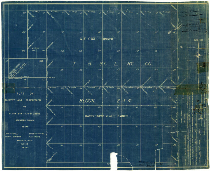
Brewster County Rolled Sketch 64
Print $20.00
- Digital $50.00
Brewster County Rolled Sketch 64
1940
Size 17.1 x 21.0 inches
Map/Doc 5232
Edwards County Sketch File 52

Print $20.00
- Digital $50.00
Edwards County Sketch File 52
1972
Size 19.9 x 35.1 inches
Map/Doc 11446
Perspective Map of the City of Laredo, Texas, the Gateway to and from Mexico

Print $20.00
Perspective Map of the City of Laredo, Texas, the Gateway to and from Mexico
1892
Size 24.0 x 36.7 inches
Map/Doc 93478
Wharton County Sketch File 7

Print $4.00
- Digital $50.00
Wharton County Sketch File 7
1879
Size 7.7 x 9.7 inches
Map/Doc 39925
Flight Mission No. BRE-1P, Frame 138, Nueces County

Print $20.00
- Digital $50.00
Flight Mission No. BRE-1P, Frame 138, Nueces County
1956
Size 18.4 x 22.3 inches
Map/Doc 86698
[Blocks 56 and 57, Townships 1 and 2]
![91315, [Blocks 56 and 57, Townships 1 and 2], Twichell Survey Records](https://historictexasmaps.com/wmedia_w700/maps/91315-1.tif.jpg)
Print $20.00
- Digital $50.00
[Blocks 56 and 57, Townships 1 and 2]
Size 19.3 x 20.5 inches
Map/Doc 91315
Red River County Sketch File 28

Print $22.00
- Digital $50.00
Red River County Sketch File 28
1995
Size 11.3 x 8.9 inches
Map/Doc 35165
Hidalgo County Sketch File 19

Print $42.00
- Digital $50.00
Hidalgo County Sketch File 19
1983
Size 11.3 x 8.9 inches
Map/Doc 26448