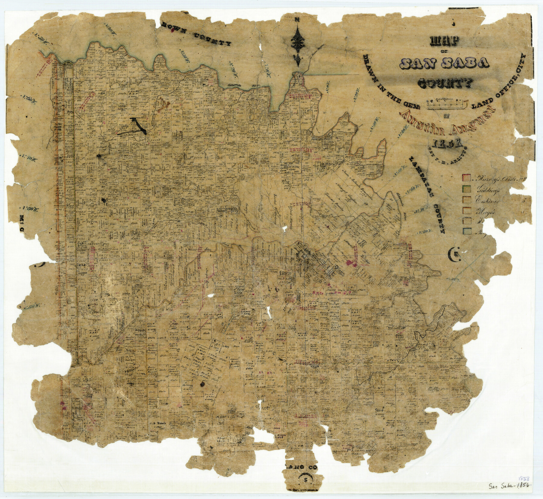
Map of San Saba County
-
Map/Doc
4019
-
Collection
General Map Collection
-
Object Dates
8/1858 (Creation Date)
-
People and Organizations
Texas General Land Office (Publisher)
F.H. Arlitt (Draftsman)
F.H. Arlitt (Compiler)
-
Counties
San Saba
-
Subjects
County
-
Height x Width
21.6 x 23.5 inches
54.9 x 59.7 cm
-
Features
Deep Creek
San Saba
San Saba River
Bonnel Creek
Brady's Creek
Walker Creek
Keogh Creek
Mineral Creek
Nona Creek
Simpson Creek
Cherokee Creek
Parker Creek
Sulphur Spring
Waco Creek
Davis Creek
Rough Creek
Water Creek
Rock Creek
Moore Creek
Pecan Bayou
Colorado River
Terrace Creek
Wilbarger Creek
Rocky Creek
Felsen Creek
Spring Creek
Kerr Creek
Salt Creek
Horse Creek
Ripp Creek
Jobs Creek
Richland Creek
China Creek
Camp Creek
Mary Creek
Part of: General Map Collection
Edwards County Rolled Sketch 16

Print $20.00
- Digital $50.00
Edwards County Rolled Sketch 16
1944
Size 29.2 x 21.1 inches
Map/Doc 5804
Hood County Working Sketch 23

Print $20.00
- Digital $50.00
Hood County Working Sketch 23
1993
Size 23.6 x 32.9 inches
Map/Doc 66217
Walker County Working Sketch 5

Print $20.00
- Digital $50.00
Walker County Working Sketch 5
1934
Size 24.5 x 30.8 inches
Map/Doc 72285
Flight Mission No. CRC-2R, Frame 4, Chambers County

Print $20.00
- Digital $50.00
Flight Mission No. CRC-2R, Frame 4, Chambers County
1956
Size 18.7 x 22.4 inches
Map/Doc 84723
Coke County Working Sketch 8

Print $20.00
- Digital $50.00
Coke County Working Sketch 8
1926
Size 26.9 x 25.5 inches
Map/Doc 68045
[Surveys in Austin's Colony along Saline Creek]
![180, [Surveys in Austin's Colony along Saline Creek], General Map Collection](https://historictexasmaps.com/wmedia_w700/maps/180.tif.jpg)
Print $20.00
- Digital $50.00
[Surveys in Austin's Colony along Saline Creek]
Size 20.8 x 20.7 inches
Map/Doc 180
Culberson County Sketch File EM and RJ

Print $24.00
- Digital $50.00
Culberson County Sketch File EM and RJ
Size 13.3 x 8.8 inches
Map/Doc 20157
Jack County Working Sketch 7

Print $20.00
- Digital $50.00
Jack County Working Sketch 7
1953
Size 37.2 x 31.9 inches
Map/Doc 66433
Val Verde County Working Sketch 86

Print $20.00
- Digital $50.00
Val Verde County Working Sketch 86
1973
Size 42.1 x 43.8 inches
Map/Doc 72221
Texas Intracoastal Waterway - Stover Point to Port Brownsville including Brazos Santiago

Print $20.00
- Digital $50.00
Texas Intracoastal Waterway - Stover Point to Port Brownsville including Brazos Santiago
1957
Size 27.6 x 38.9 inches
Map/Doc 73518
Hockley County Sketch File 10

Print $6.00
- Digital $50.00
Hockley County Sketch File 10
1921
Size 11.2 x 8.8 inches
Map/Doc 26541
Bell County Sketch File 15

Print $4.00
- Digital $50.00
Bell County Sketch File 15
1861
Size 6.4 x 8.0 inches
Map/Doc 14394
You may also like
Flight Mission No. DIX-6P, Frame 134, Aransas County

Print $20.00
- Digital $50.00
Flight Mission No. DIX-6P, Frame 134, Aransas County
1956
Size 18.8 x 22.4 inches
Map/Doc 83840
Flight Mission No. CUG-1P, Frame 106, Kleberg County

Print $20.00
- Digital $50.00
Flight Mission No. CUG-1P, Frame 106, Kleberg County
1956
Size 18.8 x 22.3 inches
Map/Doc 86156
Kenedy County Rolled Sketch 5

Print $20.00
- Digital $50.00
Kenedy County Rolled Sketch 5
1911
Size 27.9 x 24.4 inches
Map/Doc 6462
Knox County Working Sketch 16

Print $20.00
- Digital $50.00
Knox County Working Sketch 16
1963
Size 21.9 x 22.0 inches
Map/Doc 70258
Brewster County Working Sketch 5

Print $20.00
- Digital $50.00
Brewster County Working Sketch 5
1908
Size 28.0 x 22.0 inches
Map/Doc 67538
Armstrong County

Print $20.00
- Digital $50.00
Armstrong County
1933
Size 44.0 x 41.3 inches
Map/Doc 1773
[The S.K. Ry. of Texas, State Line to Pecos, Reeves Co., Texas]
![64159, [The S.K. Ry. of Texas, State Line to Pecos, Reeves Co., Texas], General Map Collection](https://historictexasmaps.com/wmedia_w700/maps/64159.tif.jpg)
Print $40.00
- Digital $50.00
[The S.K. Ry. of Texas, State Line to Pecos, Reeves Co., Texas]
1910
Size 19.4 x 130.6 inches
Map/Doc 64159
Taylor County Working Sketch 10

Print $20.00
- Digital $50.00
Taylor County Working Sketch 10
1955
Size 21.6 x 25.5 inches
Map/Doc 69620
McLennan County Working Sketch 4

Print $20.00
- Digital $50.00
McLennan County Working Sketch 4
1941
Size 19.2 x 27.9 inches
Map/Doc 70697
Brewster County Working Sketch 114

Print $20.00
- Digital $50.00
Brewster County Working Sketch 114
1983
Size 36.0 x 31.7 inches
Map/Doc 67714
Denton County Sketch File 6

Print $4.00
- Digital $50.00
Denton County Sketch File 6
1855
Size 12.3 x 8.3 inches
Map/Doc 20696
Flight Mission No. BRE-2P, Frame 104, Nueces County

Print $20.00
- Digital $50.00
Flight Mission No. BRE-2P, Frame 104, Nueces County
1956
Size 18.5 x 22.5 inches
Map/Doc 86789