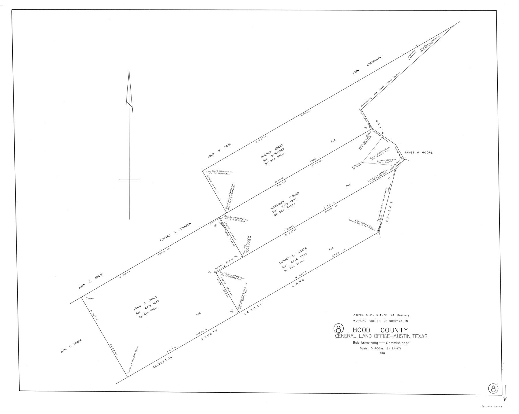
Hood County Working Sketch 8
-
Map/Doc
66202
-
Collection
General Map Collection
-
Object Dates
2/12/1971 (Creation Date)
-
Counties
Hood
-
Subjects
Surveying Working Sketch
-
Height x Width
30.1 x 37.8 inches
76.5 x 96.0 cm
-
Scale
1" = 400 varas
Part of: General Map Collection
Flight Mission No. DIX-5P, Frame 143, Aransas County

Print $20.00
- Digital $50.00
Flight Mission No. DIX-5P, Frame 143, Aransas County
1956
Size 17.0 x 17.1 inches
Map/Doc 83804
Potter County Sketch File 15

Print $20.00
- Digital $50.00
Potter County Sketch File 15
Size 19.5 x 21.1 inches
Map/Doc 12201
Anderson County Boundary File 1

Print $10.00
- Digital $50.00
Anderson County Boundary File 1
Size 14.2 x 8.6 inches
Map/Doc 49726
Brooks County Working Sketch 14

Print $20.00
- Digital $50.00
Brooks County Working Sketch 14
1944
Size 29.2 x 20.0 inches
Map/Doc 67798
Flight Mission No. BRA-7M, Frame 30, Jefferson County

Print $20.00
- Digital $50.00
Flight Mission No. BRA-7M, Frame 30, Jefferson County
1953
Size 18.6 x 22.3 inches
Map/Doc 85481
Ward County Working Sketch 21

Print $20.00
- Digital $50.00
Ward County Working Sketch 21
1953
Size 20.9 x 14.7 inches
Map/Doc 72327
Delta County Sketch File 1

Print $4.00
- Digital $50.00
Delta County Sketch File 1
1871
Size 12.7 x 8.1 inches
Map/Doc 20666
San Luis Pass to East Matagorda Bay

Print $40.00
- Digital $50.00
San Luis Pass to East Matagorda Bay
1982
Size 35.6 x 49.3 inches
Map/Doc 69970
Houston, Capital of Texas, 1837

Print $21.65
Houston, Capital of Texas, 1837
2007
Size 17.4 x 24.3 inches
Map/Doc 89272
Knox County Sketch File 11

Print $20.00
- Digital $50.00
Knox County Sketch File 11
1892
Size 26.8 x 21.9 inches
Map/Doc 11959
San Patricio County Sketch File 9

Print $2.00
- Digital $50.00
San Patricio County Sketch File 9
1846
Size 8.3 x 8.7 inches
Map/Doc 36039
Bell County Working Sketch 1

Print $20.00
- Digital $50.00
Bell County Working Sketch 1
1915
Size 20.7 x 13.2 inches
Map/Doc 67341
You may also like
Henderson County Boundary File 3c

Print $40.00
- Digital $50.00
Henderson County Boundary File 3c
Size 22.5 x 80.6 inches
Map/Doc 54707
Nolan County Sketch File A

Print $20.00
- Digital $50.00
Nolan County Sketch File A
Size 22.4 x 19.9 inches
Map/Doc 42170
General Highway Map, Hidalgo County, Texas

Print $20.00
General Highway Map, Hidalgo County, Texas
1961
Size 18.1 x 24.9 inches
Map/Doc 79518
Bowie County Working Sketch 3

Print $20.00
- Digital $50.00
Bowie County Working Sketch 3
1913
Size 25.5 x 17.1 inches
Map/Doc 67407
Guadalupe County Sketch File 20

Print $6.00
- Digital $50.00
Guadalupe County Sketch File 20
1912
Size 11.1 x 8.7 inches
Map/Doc 24699
Flight Mission No. DQO-8K, Frame 9, Galveston County

Print $20.00
- Digital $50.00
Flight Mission No. DQO-8K, Frame 9, Galveston County
1952
Size 18.7 x 22.5 inches
Map/Doc 85132
Wendlandt's Subdivision of part of Outlot 4, Division "Z"

Print $20.00
- Digital $50.00
Wendlandt's Subdivision of part of Outlot 4, Division "Z"
1910
Size 18.0 x 13.6 inches
Map/Doc 83428
Texas, Brazos River, Freeport

Print $40.00
- Digital $50.00
Texas, Brazos River, Freeport
1933
Size 28.4 x 48.3 inches
Map/Doc 69994
Lamb County Sketch File 18

Print $4.00
- Digital $50.00
Lamb County Sketch File 18
1979
Size 14.3 x 8.9 inches
Map/Doc 29381
Reagan County Working Sketch 13

Print $40.00
- Digital $50.00
Reagan County Working Sketch 13
1948
Size 23.8 x 50.8 inches
Map/Doc 71853
Armstrong County

Print $20.00
- Digital $50.00
Armstrong County
1933
Size 42.3 x 41.0 inches
Map/Doc 73071
La Salle County Working Sketch 40

Print $20.00
- Digital $50.00
La Salle County Working Sketch 40
1968
Size 23.0 x 19.2 inches
Map/Doc 70341