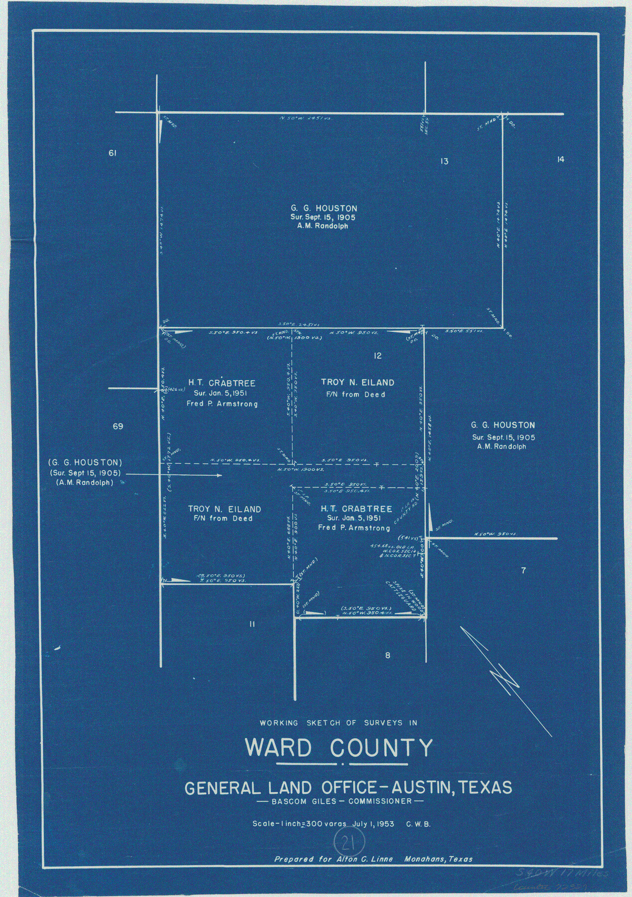
Ward County Working Sketch 21
-
Map/Doc
72327
-
Collection
General Map Collection
-
Object Dates
7/1/1953 (Creation Date)
-
Counties
Ward
-
Subjects
Surveying Working Sketch
-
Height x Width
20.9 x 14.7 inches
53.1 x 37.3 cm
-
Scale
1" = 300 varas
Part of: General Map Collection
Navigation Maps of Gulf Intracoastal Waterway, Port Arthur to Brownsville, Texas

Print $4.00
- Digital $50.00
Navigation Maps of Gulf Intracoastal Waterway, Port Arthur to Brownsville, Texas
1951
Size 16.7 x 21.2 inches
Map/Doc 65449
Nolan County Working Sketch 1

Print $20.00
- Digital $50.00
Nolan County Working Sketch 1
1928
Size 17.9 x 17.5 inches
Map/Doc 71292
Caldwell County Rolled Sketch 1

Print $20.00
- Digital $50.00
Caldwell County Rolled Sketch 1
1953
Size 20.2 x 30.4 inches
Map/Doc 10673
Wise County Sketch File 54

Print $22.00
- Digital $50.00
Wise County Sketch File 54
2012
Size 11.0 x 8.5 inches
Map/Doc 93553
Cass County Sketch File 4

Print $6.00
- Digital $50.00
Cass County Sketch File 4
1853
Size 8.2 x 11.2 inches
Map/Doc 17398
Mappa Geographica Americae Septentrionalis: ad emendatiora exemplaria adhuc edita jussu Acad. Reg. Scient. Et eleg. Litt. Descripta.

Print $20.00
- Digital $50.00
Mappa Geographica Americae Septentrionalis: ad emendatiora exemplaria adhuc edita jussu Acad. Reg. Scient. Et eleg. Litt. Descripta.
1753
Size 14.9 x 17.4 inches
Map/Doc 88882
Angelina County Sketch File 3

Print $8.00
- Digital $50.00
Angelina County Sketch File 3
Size 7.7 x 7.6 inches
Map/Doc 12922
Denton County Sketch File 4

Print $6.00
- Digital $50.00
Denton County Sketch File 4
1858
Size 12.2 x 7.9 inches
Map/Doc 20690
Crockett County Rolled Sketch 76

Print $20.00
- Digital $50.00
Crockett County Rolled Sketch 76
1950
Size 24.6 x 26.1 inches
Map/Doc 5617
Leon County Working Sketch 33

Print $20.00
- Digital $50.00
Leon County Working Sketch 33
1978
Size 43.4 x 41.6 inches
Map/Doc 70432
Donley County Working Sketch 3

Print $40.00
- Digital $50.00
Donley County Working Sketch 3
Size 58.7 x 44.8 inches
Map/Doc 68736
Map of Gillespie County

Print $20.00
- Digital $50.00
Map of Gillespie County
1857
Size 35.1 x 26.2 inches
Map/Doc 3582
You may also like
Rand, McNally & Co.'s Texas

Print $20.00
- Digital $50.00
Rand, McNally & Co.'s Texas
1895
Size 21.2 x 28.6 inches
Map/Doc 95885
North America corrected from the observations communicated to the Royal Society at London and the Royal Academy at Paris

Print $20.00
- Digital $50.00
North America corrected from the observations communicated to the Royal Society at London and the Royal Academy at Paris
1710
Size 38.9 x 26.9 inches
Map/Doc 93820
Sabine Bank to East Bay including Heald Bank
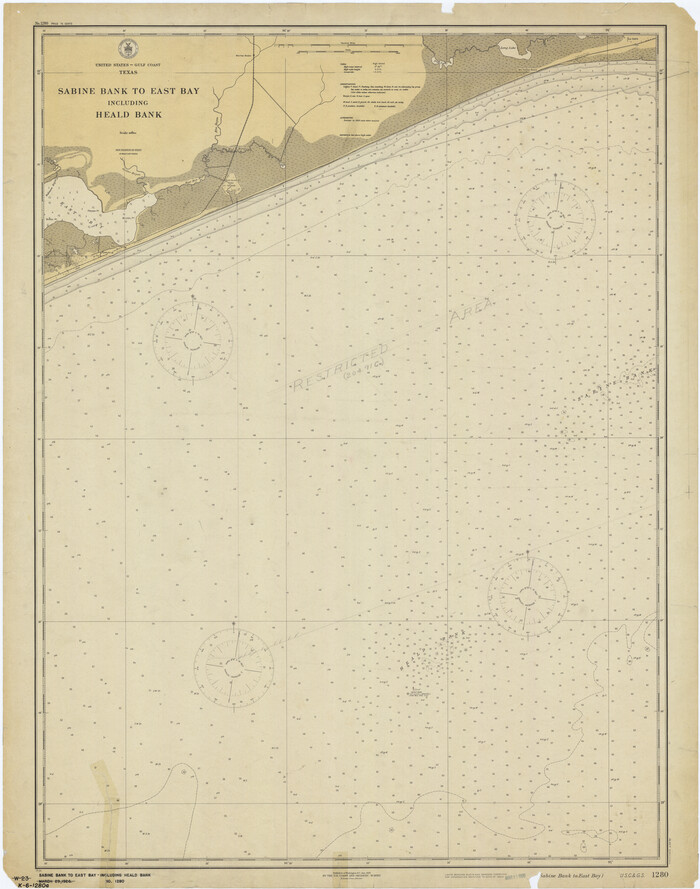
Print $20.00
- Digital $50.00
Sabine Bank to East Bay including Heald Bank
1925
Size 44.2 x 34.8 inches
Map/Doc 69844
General Highway Map, Tarrant County, Texas

Print $20.00
General Highway Map, Tarrant County, Texas
1940
Size 18.4 x 25.2 inches
Map/Doc 79251
Williamson County Sketch File 17

Print $8.00
- Digital $50.00
Williamson County Sketch File 17
1876
Size 6.5 x 8.1 inches
Map/Doc 40338
Karnes County Sketch File 13

Print $8.00
- Digital $50.00
Karnes County Sketch File 13
1897
Size 9.7 x 6.3 inches
Map/Doc 28611
Old Miscellaneous File 31

Print $8.00
- Digital $50.00
Old Miscellaneous File 31
1845
Size 8.6 x 5.6 inches
Map/Doc 75748
Galveston County NRC Article 33.136 Location Key Sheet

Print $20.00
- Digital $50.00
Galveston County NRC Article 33.136 Location Key Sheet
1994
Size 27.0 x 22.0 inches
Map/Doc 77020
Runnels County

Print $20.00
- Digital $50.00
Runnels County
1898
Size 43.3 x 36.9 inches
Map/Doc 63009
Runnels County Sketch File 28

Print $6.00
Runnels County Sketch File 28
1949
Size 11.3 x 8.8 inches
Map/Doc 35493
Northeast Part of Webb County

Print $40.00
- Digital $50.00
Northeast Part of Webb County
1986
Size 38.0 x 49.2 inches
Map/Doc 73318
[Elizabeth Stanley, William H. Anderson, and surrounding surveys]
![91022, [Elizabeth Stanley, William H. Anderson, and surrounding surveys], Twichell Survey Records](https://historictexasmaps.com/wmedia_w700/maps/91022-1.tif.jpg)
Print $20.00
- Digital $50.00
[Elizabeth Stanley, William H. Anderson, and surrounding surveys]
Size 27.0 x 18.9 inches
Map/Doc 91022