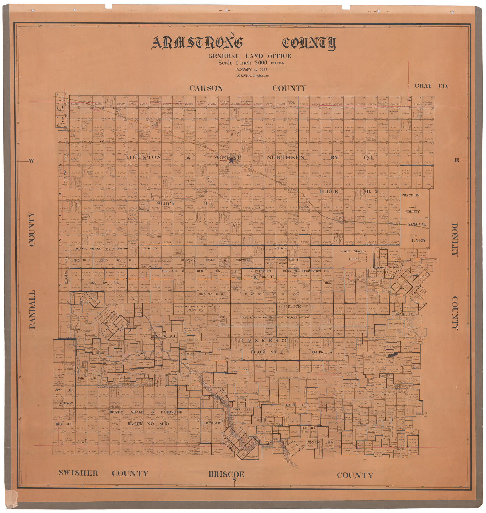
Armstrong County
-
Map/Doc
73071
-
Collection
General Map Collection
-
Object Dates
1933/1/27 (Creation Date)
-
People and Organizations
Texas General Land Office (Publisher)
W.S. Vines (Draftsman)
-
Counties
Armstrong
-
Subjects
County
-
Height x Width
42.3 x 41.0 inches
107.4 x 104.1 cm
-
Comments
Hand lettered.
Note on reverse side: "Hung February 23, 1933." -
Features
Prairie Dog Town Fork of Red River
Washburn
FW&DC
Claude
Mulberry Creek
Goodnight
Part of: General Map Collection
Flight Mission No. DIX-10P, Frame 72, Aransas County

Print $20.00
- Digital $50.00
Flight Mission No. DIX-10P, Frame 72, Aransas County
1956
Size 18.8 x 22.4 inches
Map/Doc 83933
Aransas County Rolled Sketch 19C

Print $20.00
- Digital $50.00
Aransas County Rolled Sketch 19C
Size 40.9 x 30.6 inches
Map/Doc 5063
Shackelford County Sketch File 7

Print $20.00
- Digital $50.00
Shackelford County Sketch File 7
1912
Size 27.2 x 13.5 inches
Map/Doc 12314

Denton County Working Sketch 16

Print $20.00
- Digital $50.00
Denton County Working Sketch 16
1973
Size 31.5 x 39.1 inches
Map/Doc 68621
Shackelford County Boundary File 7b

Print $90.00
- Digital $50.00
Shackelford County Boundary File 7b
Size 7.9 x 10.4 inches
Map/Doc 58692
Railroad Track Map, H&TCRRCo., Falls County, Texas

Print $4.00
- Digital $50.00
Railroad Track Map, H&TCRRCo., Falls County, Texas
1918
Size 11.8 x 18.6 inches
Map/Doc 62840
Hutchinson County Rolled Sketch 43

Print $40.00
- Digital $50.00
Hutchinson County Rolled Sketch 43
1992
Size 40.4 x 49.4 inches
Map/Doc 6313
Jackson County Working Sketch 2

Print $20.00
- Digital $50.00
Jackson County Working Sketch 2
1937
Size 41.5 x 38.0 inches
Map/Doc 66450
Hudspeth County Working Sketch 34

Print $40.00
- Digital $50.00
Hudspeth County Working Sketch 34
1977
Size 63.1 x 37.3 inches
Map/Doc 66319
A Map of Sterling County

Print $20.00
- Digital $50.00
A Map of Sterling County
1919
Size 33.3 x 21.6 inches
Map/Doc 4054
Edwards County

Print $20.00
- Digital $50.00
Edwards County
1883
Size 28.2 x 17.9 inches
Map/Doc 3505
You may also like
Flight Mission No. CRC-2R, Frame 185, Chambers County

Print $20.00
- Digital $50.00
Flight Mission No. CRC-2R, Frame 185, Chambers County
1956
Size 18.8 x 22.4 inches
Map/Doc 84763

Brewster County Sketch File 21

Print $40.00
- Digital $50.00
Brewster County Sketch File 21
Size 23.1 x 18.9 inches
Map/Doc 10980
Map of Nacogdoches County

Print $20.00
- Digital $50.00
Map of Nacogdoches County
1881
Size 23.7 x 21.0 inches
Map/Doc 4599
Wilbarger County Aerial Photograph Index Sheet 1

Print $20.00
- Digital $50.00
Wilbarger County Aerial Photograph Index Sheet 1
1950
Size 22.4 x 18.9 inches
Map/Doc 83750
Flight Mission No. DCL-4C, Frame 95, Kenedy County

Print $20.00
- Digital $50.00
Flight Mission No. DCL-4C, Frame 95, Kenedy County
1943
Size 18.7 x 22.3 inches
Map/Doc 85816
Green & Lumsden's Ranch

Print $20.00
- Digital $50.00
Green & Lumsden's Ranch
Size 28.4 x 24.7 inches
Map/Doc 92431
Webb County Working Sketch 18

Print $20.00
- Digital $50.00
Webb County Working Sketch 18
1923
Size 18.6 x 12.8 inches
Map/Doc 72383
Houston County Working Sketch 11

Print $20.00
- Digital $50.00
Houston County Working Sketch 11
1953
Size 28.5 x 24.5 inches
Map/Doc 66241
Cherokee County Working Sketch 18

Print $40.00
- Digital $50.00
Cherokee County Working Sketch 18
1958
Size 74.6 x 43.6 inches
Map/Doc 67973
Cass County Sketch File 7

Print $4.00
- Digital $50.00
Cass County Sketch File 7
1853
Size 8.0 x 12.6 inches
Map/Doc 17408
Matagorda Light to Aransas Pass

Print $20.00
- Digital $50.00
Matagorda Light to Aransas Pass
1946
Size 35.8 x 44.5 inches
Map/Doc 73394