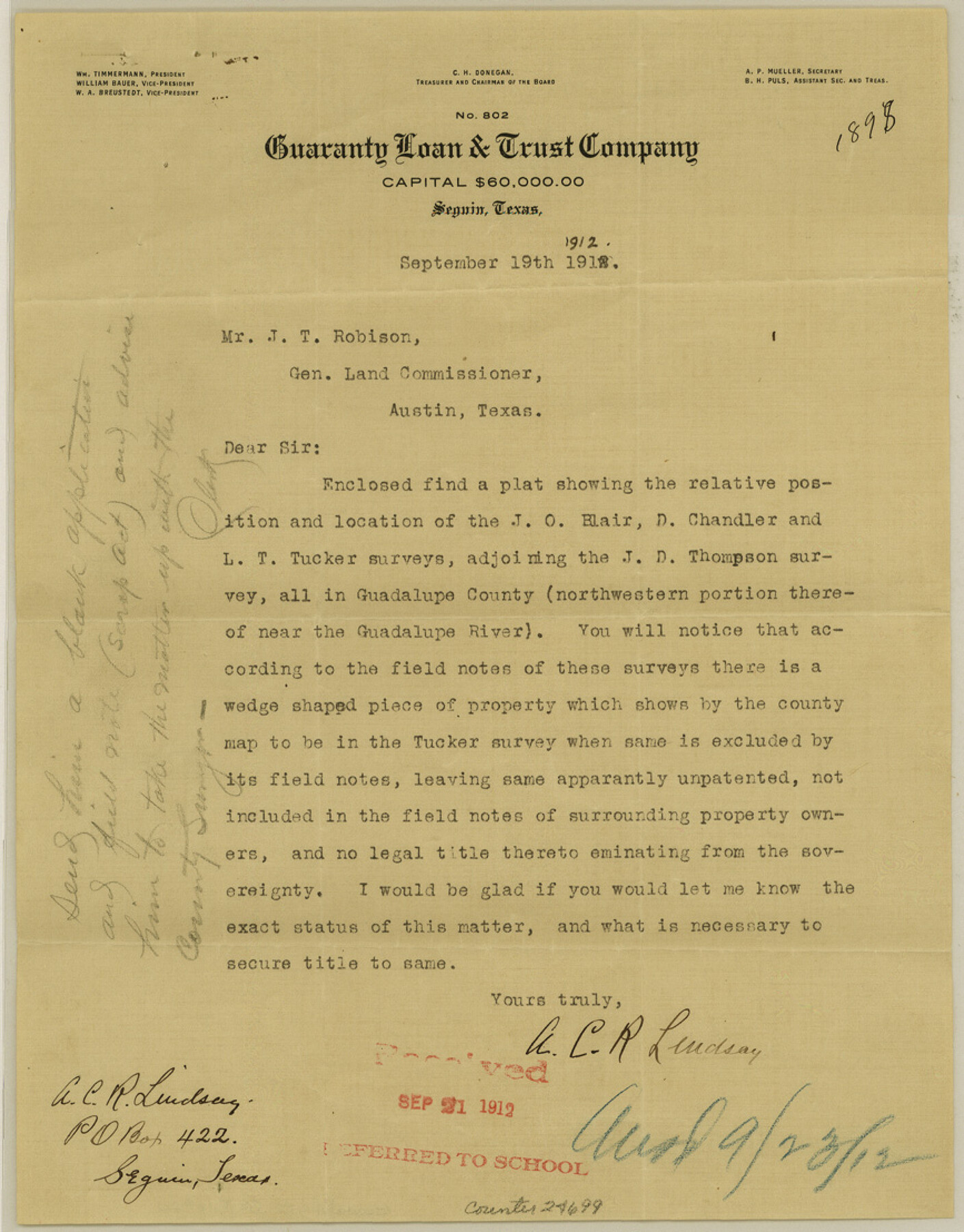
Guadalupe County Sketch File 20
[Inquiry and sketch as to a vacancy joining the J. D. Thompson survey]
-
Map/Doc
24699
-
Collection
General Map Collection
-
Object Dates
1912/9/19 (Creation Date)
1912/9/21 (File Date)
-
People and Organizations
A.C.R. Lindsey (Surveyor/Engineer)
-
Counties
Guadalupe Comal
-
Subjects
Surveying Sketch File
-
Height x Width
11.1 x 8.7 inches
28.2 x 22.1 cm
-
Medium
multi-page, multi-format
-
Scale
1:2000
-
Features
Guadalupe River
Part of: General Map Collection
Flight Mission No. BRA-7M, Frame 122, Jefferson County

Print $20.00
- Digital $50.00
Flight Mission No. BRA-7M, Frame 122, Jefferson County
1953
Size 18.7 x 22.3 inches
Map/Doc 85516
Andrews County Rolled Sketch 26

Print $40.00
- Digital $50.00
Andrews County Rolled Sketch 26
1948
Size 78.3 x 13.2 inches
Map/Doc 8398
Matagorda Bay and Approaches

Print $20.00
- Digital $50.00
Matagorda Bay and Approaches
1946
Size 35.2 x 44.8 inches
Map/Doc 73379
Texas Intracoastal Waterway - Laguna Madre - Rincon de San Jose to Chubby Island

Print $20.00
- Digital $50.00
Texas Intracoastal Waterway - Laguna Madre - Rincon de San Jose to Chubby Island
1957
Size 38.9 x 27.3 inches
Map/Doc 73513
San Patricio County Rolled Sketch 34

Print $20.00
- Digital $50.00
San Patricio County Rolled Sketch 34
Size 25.8 x 26.2 inches
Map/Doc 7584
Pecos County Working Sketch 50

Print $20.00
- Digital $50.00
Pecos County Working Sketch 50
1947
Size 21.1 x 13.4 inches
Map/Doc 71522
Jeff Davis County Sketch File 17

Print $6.00
- Digital $50.00
Jeff Davis County Sketch File 17
1884
Size 8.8 x 7.3 inches
Map/Doc 27948
Garza County Working Sketch 1

Print $20.00
- Digital $50.00
Garza County Working Sketch 1
1902
Size 39.3 x 25.6 inches
Map/Doc 63148
Morris County Working Sketch Graphic Index

Print $20.00
- Digital $50.00
Morris County Working Sketch Graphic Index
1948
Size 42.8 x 20.1 inches
Map/Doc 76649
Flight Mission No. DAG-19K, Frame 65, Matagorda County

Print $20.00
- Digital $50.00
Flight Mission No. DAG-19K, Frame 65, Matagorda County
1952
Size 18.5 x 22.3 inches
Map/Doc 86392

Map of survey of a part of Padre and Mustang Islands made for the Office of the Attorney General of the State of Texas

Print $20.00
- Digital $50.00
Map of survey of a part of Padre and Mustang Islands made for the Office of the Attorney General of the State of Texas
1941
Size 40.8 x 39.5 inches
Map/Doc 2257
You may also like
Liberty County Sketch File 26

Print $10.00
- Digital $50.00
Liberty County Sketch File 26
1859
Size 8.3 x 9.2 inches
Map/Doc 29943
Bexar County Sketch File 53

Print $8.00
- Digital $50.00
Bexar County Sketch File 53
Size 11.4 x 8.9 inches
Map/Doc 14539
Flight Mission No. CLL-1N, Frame 194, Willacy County

Print $20.00
- Digital $50.00
Flight Mission No. CLL-1N, Frame 194, Willacy County
1954
Size 18.5 x 22.1 inches
Map/Doc 87064
Sutton County Working Sketch 59

Print $40.00
- Digital $50.00
Sutton County Working Sketch 59
1957
Size 30.2 x 78.4 inches
Map/Doc 62402
[Subdivision of Crockett County School Land Lgs. 214-217]
![90106, [Subdivision of Crockett County School Land Lgs. 214-217], Twichell Survey Records](https://historictexasmaps.com/wmedia_w700/maps/90106-1.tif.jpg)
Print $2.00
- Digital $50.00
[Subdivision of Crockett County School Land Lgs. 214-217]
Size 12.4 x 8.5 inches
Map/Doc 90106
Brazoria County

Print $20.00
- Digital $50.00
Brazoria County
1879
Size 26.6 x 25.1 inches
Map/Doc 859
[Kansas City, Mexico & Orient] Located Line of the Panhandle and Gulf RY. Through Stand Lands, Public School and University, In Presidio County Texas, Right of Way 200 feet Wide
![64269, [Kansas City, Mexico & Orient] Located Line of the Panhandle and Gulf RY. Through Stand Lands, Public School and University, In Presidio County Texas, Right of Way 200 feet Wide, General Map Collection](https://historictexasmaps.com/wmedia_w700/maps/64269-1.tif.jpg)
Print $40.00
- Digital $50.00
[Kansas City, Mexico & Orient] Located Line of the Panhandle and Gulf RY. Through Stand Lands, Public School and University, In Presidio County Texas, Right of Way 200 feet Wide
1904
Size 15.6 x 70.3 inches
Map/Doc 64269
Walker County Working Sketch 16

Print $20.00
- Digital $50.00
Walker County Working Sketch 16
1983
Size 36.5 x 42.4 inches
Map/Doc 72296
Taylor County Working Sketch 9

Print $20.00
- Digital $50.00
Taylor County Working Sketch 9
1955
Size 24.2 x 24.6 inches
Map/Doc 69619
Kimble County Sketch File 39

Print $12.00
- Digital $50.00
Kimble County Sketch File 39
1885
Size 14.1 x 8.6 inches
Map/Doc 28997
Baylor County Sketch File 30

Print $14.00
- Digital $50.00
Baylor County Sketch File 30
Size 11.4 x 9.0 inches
Map/Doc 14228
Flight Mission No. DCL-6C, Frame 177, Kenedy County

Print $20.00
- Digital $50.00
Flight Mission No. DCL-6C, Frame 177, Kenedy County
1943
Size 18.5 x 22.2 inches
Map/Doc 85989