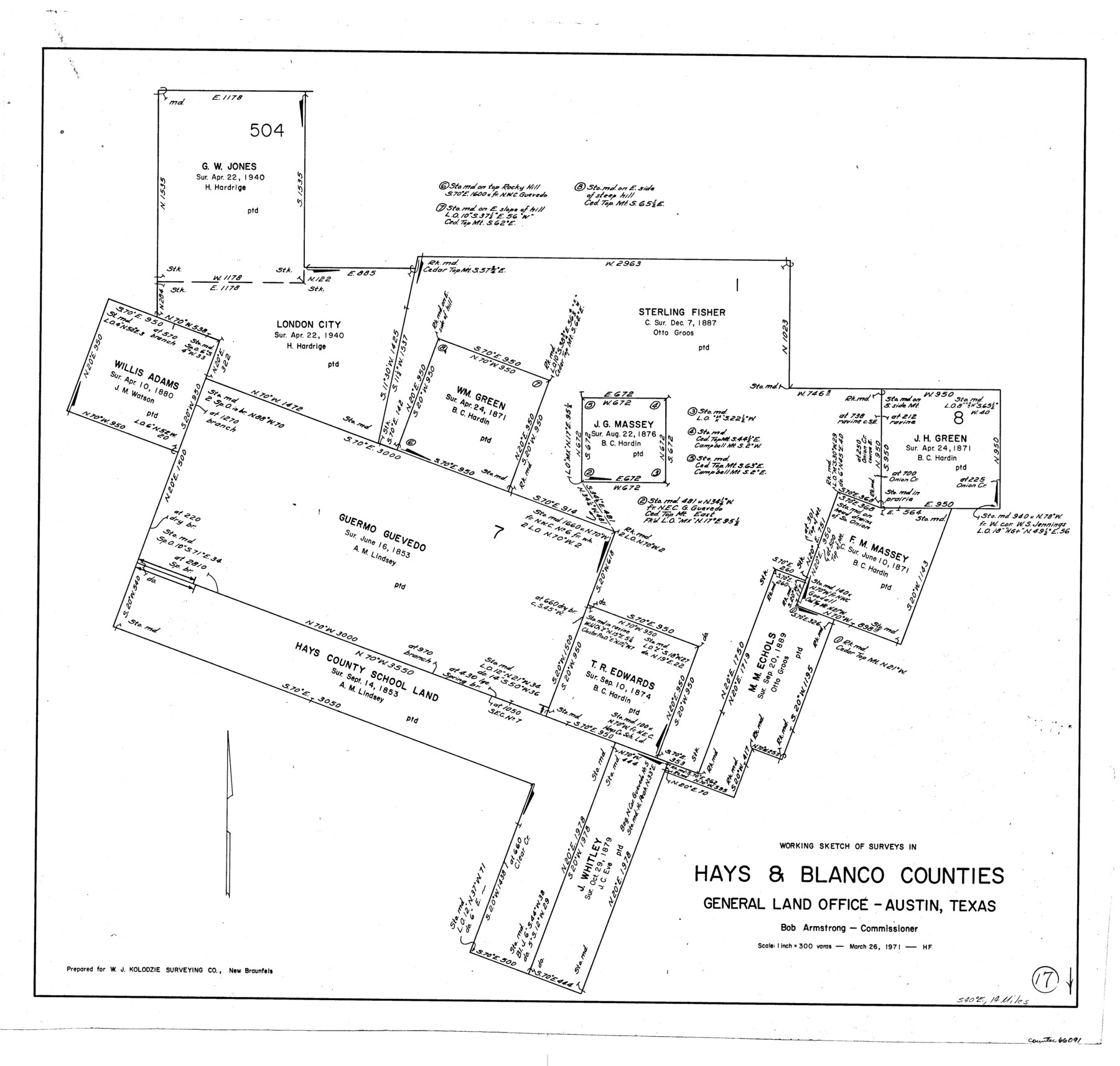
Hays County Working Sketch 17
-
Map/Doc
66091
-
Collection
General Map Collection
-
Object Dates
3/26/1971 (Creation Date)
-
People and Organizations
Herman Forbes (Draftsman)
-
Counties
Hays Blanco
-
Subjects
Surveying Working Sketch
-
Height x Width
28.6 x 30.0 inches
72.6 x 76.2 cm
-
Scale
1" = 300 varas
Part of: General Map Collection
Bell County Working Sketch 3

Print $3.00
- Digital $50.00
Bell County Working Sketch 3
1940
Size 10.8 x 12.8 inches
Map/Doc 67343
Duval County Sketch File 29

Print $6.00
- Digital $50.00
Duval County Sketch File 29
1932
Size 14.6 x 8.8 inches
Map/Doc 21336
Orange County NRC Article 33.136 Location Key Sheet

Print $20.00
- Digital $50.00
Orange County NRC Article 33.136 Location Key Sheet
1974
Size 27.0 x 23.0 inches
Map/Doc 87911
Coke County Sketch File 35

Print $6.00
- Digital $50.00
Coke County Sketch File 35
1967
Size 14.2 x 8.6 inches
Map/Doc 18649
Flight Mission No. BRA-8M, Frame 77, Jefferson County

Print $20.00
- Digital $50.00
Flight Mission No. BRA-8M, Frame 77, Jefferson County
1953
Size 15.9 x 15.7 inches
Map/Doc 85597
Right of Way Map Fort Worth & Denver City Railroad through Hardeman County

Print $40.00
- Digital $50.00
Right of Way Map Fort Worth & Denver City Railroad through Hardeman County
1885
Size 23.8 x 60.4 inches
Map/Doc 64425
Harrison County Rolled Sketch 15

Print $20.00
- Digital $50.00
Harrison County Rolled Sketch 15
2008
Size 20.5 x 21.0 inches
Map/Doc 89045
Laguna Madre, T-9210

Print $20.00
- Digital $50.00
Laguna Madre, T-9210
Size 34.6 x 31.9 inches
Map/Doc 73601
Controlled Mosaic by Jack Amman Photogrammetric Engineers, Inc - Sheet 45

Print $20.00
- Digital $50.00
Controlled Mosaic by Jack Amman Photogrammetric Engineers, Inc - Sheet 45
1954
Size 20.0 x 24.0 inches
Map/Doc 83504
Copy of Surveyor's Field Book, Morris Browning - In Blocks 7, 5 & 4, I&GNRRCo., Hutchinson and Carson Counties, Texas

Print $2.00
- Digital $50.00
Copy of Surveyor's Field Book, Morris Browning - In Blocks 7, 5 & 4, I&GNRRCo., Hutchinson and Carson Counties, Texas
1888
Size 6.9 x 8.9 inches
Map/Doc 62285
Taylor County Rolled Sketch 27A

Print $20.00
- Digital $50.00
Taylor County Rolled Sketch 27A
Size 30.5 x 21.4 inches
Map/Doc 7919
Haskell County Rolled Sketch 7

Print $20.00
- Digital $50.00
Haskell County Rolled Sketch 7
1940
Size 22.0 x 26.5 inches
Map/Doc 6167
You may also like
Hudspeth County Rolled Sketch 60

Print $20.00
- Digital $50.00
Hudspeth County Rolled Sketch 60
1982
Size 43.4 x 44.4 inches
Map/Doc 9225
Childress County, Texas

Print $20.00
- Digital $50.00
Childress County, Texas
1892
Size 29.3 x 22.0 inches
Map/Doc 697
General Highway Map, Bexar County, Texas

Print $20.00
General Highway Map, Bexar County, Texas
1940
Size 18.3 x 25.1 inches
Map/Doc 79017
Comal County Sketch File 7

Print $4.00
- Digital $50.00
Comal County Sketch File 7
Size 13.5 x 8.3 inches
Map/Doc 19011
Terrell County Working Sketch 76

Print $20.00
- Digital $50.00
Terrell County Working Sketch 76
1982
Size 31.8 x 20.1 inches
Map/Doc 69597
Right of Way and Track Map, Houston & Texas Central R.R. operated by the T. and N. O. R.R., Fort Worth Branch

Print $40.00
- Digital $50.00
Right of Way and Track Map, Houston & Texas Central R.R. operated by the T. and N. O. R.R., Fort Worth Branch
1918
Size 31.7 x 56.8 inches
Map/Doc 64784
[Wilson Strickland Survey]
![91285, [Wilson Strickland Survey], Twichell Survey Records](https://historictexasmaps.com/wmedia_w700/maps/91285-1.tif.jpg)
Print $20.00
- Digital $50.00
[Wilson Strickland Survey]
Size 12.7 x 19.2 inches
Map/Doc 91285

Upton County Sketch File 36

Print $14.00
- Digital $50.00
Upton County Sketch File 36
1952
Size 11.3 x 8.8 inches
Map/Doc 38893
Medina County Working Sketch 30

Print $20.00
- Digital $50.00
Medina County Working Sketch 30
1992
Size 19.2 x 15.4 inches
Map/Doc 70945
Flight Mission No. CRE-2R, Frame 165, Jackson County

Print $20.00
- Digital $50.00
Flight Mission No. CRE-2R, Frame 165, Jackson County
1956
Size 18.5 x 22.3 inches
Map/Doc 85375
General Highway Map, Nueces County, Texas

Print $20.00
General Highway Map, Nueces County, Texas
1940
Size 24.6 x 18.4 inches
Map/Doc 79210