Upton County Sketch File 36
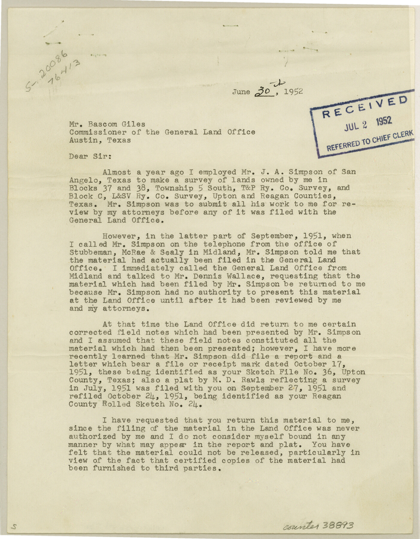
[Surveyor's report of a resurvey of Block C, L. & S. V. R.R. Co. and Block 37, T. & P. R.R. Co., Township 5S]
-
Map/Doc
38893
-
Collection
General Map Collection
-
Object Dates
1952/7/2 (File Date)
1952/6/30 (Creation Date)
-
People and Organizations
George Williams (Surveyor/Engineer)
Robert E. Estes (Surveyor/Engineer)
J.A. Simpson (Surveyor/Engineer)
-
Counties
Upton Reagan Midland Glasscock
-
Subjects
Surveying Sketch File
-
Height x Width
11.3 x 8.8 inches
28.7 x 22.4 cm
-
Medium
paper, print
-
Comments
See Reagan County Rolled Sketch 24 (9819) for sketch.
Related maps
Reagan County Rolled Sketch 24

Print $26.00
- Digital $50.00
Reagan County Rolled Sketch 24
Size 44.0 x 39.9 inches
Map/Doc 9819
Part of: General Map Collection
Dallam County Sketch File 3

Print $4.00
- Digital $50.00
Dallam County Sketch File 3
Size 14.6 x 9.0 inches
Map/Doc 20337
Tom Green County Working Sketch Graphic Index

Print $40.00
- Digital $50.00
Tom Green County Working Sketch Graphic Index
1942
Size 70.9 x 40.1 inches
Map/Doc 76715
Galveston County NRC Article 33.136 Sketch 88

Print $42.00
- Digital $50.00
Galveston County NRC Article 33.136 Sketch 88
2019
Size 24.6 x 36.3 inches
Map/Doc 95735
Flight Mission No. DAG-22K, Frame 81, Matagorda County

Print $20.00
- Digital $50.00
Flight Mission No. DAG-22K, Frame 81, Matagorda County
1953
Size 18.6 x 22.4 inches
Map/Doc 86465
Flight Mission No. DCL-6C, Frame 51, Kenedy County

Print $20.00
- Digital $50.00
Flight Mission No. DCL-6C, Frame 51, Kenedy County
1943
Size 18.6 x 22.4 inches
Map/Doc 85893
Ochiltree County Working Sketch 8

Print $20.00
- Digital $50.00
Ochiltree County Working Sketch 8
1982
Size 23.4 x 20.8 inches
Map/Doc 71321
Burnet County Boundary File 1

Print $28.00
- Digital $50.00
Burnet County Boundary File 1
Size 12.8 x 8.3 inches
Map/Doc 50844
Lamb County Sketch File 2

Print $40.00
- Digital $50.00
Lamb County Sketch File 2
1888
Size 17.1 x 14.4 inches
Map/Doc 29342
Edwards County Working Sketch 65

Print $20.00
- Digital $50.00
Edwards County Working Sketch 65
1956
Size 34.0 x 25.0 inches
Map/Doc 68941
Denton County Working Sketch 21

Print $20.00
- Digital $50.00
Denton County Working Sketch 21
1983
Size 37.3 x 35.8 inches
Map/Doc 68626
Duval County Sketch File 45a

Print $9.00
- Digital $50.00
Duval County Sketch File 45a
Size 14.5 x 9.0 inches
Map/Doc 21396

You may also like
[East line of Childress County along border of Oklahoma]
![91988, [East line of Childress County along border of Oklahoma], Twichell Survey Records](https://historictexasmaps.com/wmedia_w700/maps/91988-1.tif.jpg)
Print $20.00
- Digital $50.00
[East line of Childress County along border of Oklahoma]
Size 30.1 x 8.6 inches
Map/Doc 91988
Henderson County Working Sketch 21

Print $20.00
- Digital $50.00
Henderson County Working Sketch 21
1948
Size 17.1 x 16.2 inches
Map/Doc 66154
Flight Mission No. BRA-16M, Frame 56, Jefferson County

Print $20.00
- Digital $50.00
Flight Mission No. BRA-16M, Frame 56, Jefferson County
1953
Size 18.6 x 22.5 inches
Map/Doc 85673
[Central Part of County, near Morris County School Land Leagues]
![90486, [Central Part of County, near Morris County School Land Leagues], Twichell Survey Records](https://historictexasmaps.com/wmedia_w700/maps/90486-1.tif.jpg)
Print $20.00
- Digital $50.00
[Central Part of County, near Morris County School Land Leagues]
Size 13.4 x 26.3 inches
Map/Doc 90486
Eastland County Working Sketch 22

Print $20.00
- Digital $50.00
Eastland County Working Sketch 22
1920
Size 19.9 x 19.2 inches
Map/Doc 68803
Map of the Town of Dawson in John Fullerton, G. W. Rose, David Onstott and Wm. Walker Surveys

Print $20.00
- Digital $50.00
Map of the Town of Dawson in John Fullerton, G. W. Rose, David Onstott and Wm. Walker Surveys
1975
Size 43.1 x 37.1 inches
Map/Doc 93672
Randall County Boundary File 5

Print $14.00
- Digital $50.00
Randall County Boundary File 5
Size 8.9 x 7.8 inches
Map/Doc 58134
City of Lamesa, Texas

Print $40.00
- Digital $50.00
City of Lamesa, Texas
Size 52.2 x 43.2 inches
Map/Doc 89855
Corpus Christi Bay

Print $20.00
- Digital $50.00
Corpus Christi Bay
1976
Size 36.2 x 47.8 inches
Map/Doc 73476
Current Miscellaneous File 68

Print $22.00
- Digital $50.00
Current Miscellaneous File 68
Size 11.2 x 8.8 inches
Map/Doc 74134
Hutchinson County Sketch File 50

Print $12.00
- Digital $50.00
Hutchinson County Sketch File 50
1992
Size 14.2 x 8.8 inches
Map/Doc 27434
Gonzales County Working Sketch 4a

Print $20.00
- Digital $50.00
Gonzales County Working Sketch 4a
1979
Size 30.9 x 32.2 inches
Map/Doc 63219