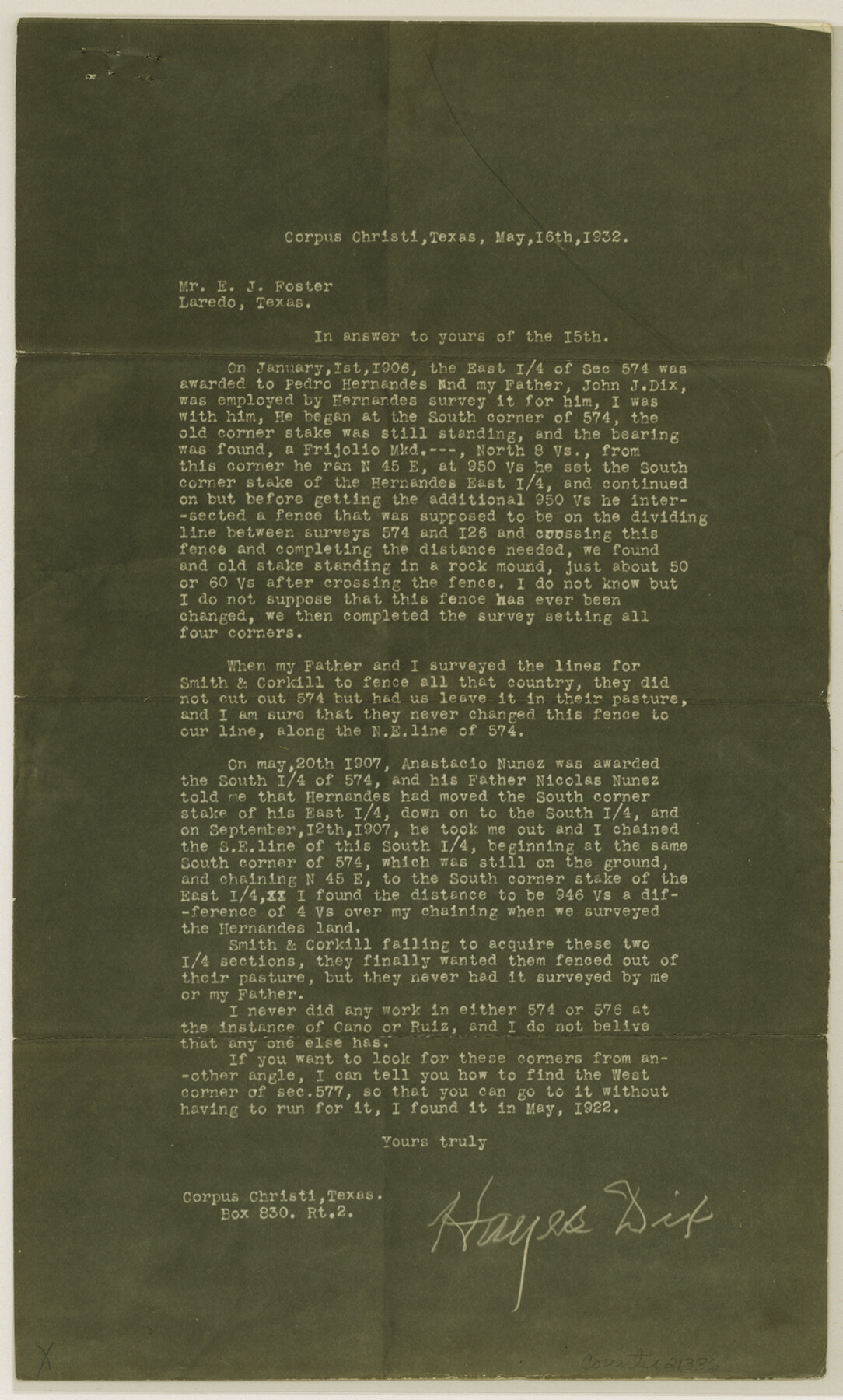
Duval County Sketch File 29
[Copy of letter regarding section 574, B. S. & F., northwest of San Diego]
- 
                          Map/Doc21336
- 
                            CollectionGeneral Map Collection
- 
                            Object Dates1932/5/16 (Creation Date)1932/6/7 (File Date)1922 (Survey Date)
- 
                            People and OrganizationsE.J. Foster (Surveyor/Engineer)John J. Dix (Surveyor/Engineer)Hayes Dix (Surveyor/Engineer)
- 
                            CountiesDuval
- 
                            SubjectsSurveying Sketch File
- 
                            Height x Width14.6 x 8.8 inches37.1 x 22.4 cm
- 
                            Mediummulti-page, multi-format
Part of: General Map Collection
            Calhoun County Aerial Photograph Index Sheet 5


                                            Print $20.00                    
                                             -                         Digital $50.00                                    
                Calhoun County Aerial Photograph Index Sheet 5
1953
Size 24.0 x 19.5 inches
                                Map/Doc 83673
            
            Flight Mission No. DIX-5P, Frame 152, Aransas County


                                            Print $20.00                    
                                             -                         Digital $50.00                                    
                Flight Mission No. DIX-5P, Frame 152, Aransas County
1956
Size 17.8 x 18.6 inches
                                Map/Doc 83814
            
            Gulf Coast of the United States, Key West to Rio Grande


                                            Print $20.00                    
                                             -                         Digital $50.00                                    
                Gulf Coast of the United States, Key West to Rio Grande
1892
Size 27.5 x 18.4 inches
                                Map/Doc 72672
            
            Flight Mission No. DQN-5K, Frame 59, Calhoun County


                                            Print $20.00                    
                                             -                         Digital $50.00                                    
                Flight Mission No. DQN-5K, Frame 59, Calhoun County
1953
Size 18.7 x 22.3 inches
                                Map/Doc 84402
            
            Red River County


                                            Print $20.00                    
                                             -                         Digital $50.00                                    
                Red River County
1860
Size 23.0 x 20.8 inches
                                Map/Doc 3980
            
            Winkler County Sketch File 14


                                            Print $20.00                    
                                             -                         Digital $50.00                                    
                Winkler County Sketch File 14
Size 29.4 x 24.3 inches
                                Map/Doc 12698
            
            Pecos County Rolled Sketch 89


                                            Print $40.00                    
                                             -                         Digital $50.00                                    
                Pecos County Rolled Sketch 89
1934
Size 56.2 x 41.4 inches
                                Map/Doc 10719
            
            Palo Pinto County Working Sketch 8


                                            Print $20.00                    
                                             -                         Digital $50.00                                    
                Palo Pinto County Working Sketch 8
1922
Map/Doc 71391
            
            Hardin County Sketch File 24b


                                            Print $4.00                    
                                             -                         Digital $50.00                                    
                Hardin County Sketch File 24b
Size 6.4 x 8.0 inches
                                Map/Doc 25146
            
            [St. Louis & Southwestern]
            
                                    ![64279, [St. Louis & Southwestern], General Map Collection](https://historictexasmaps.com/wmedia_w700/maps/64279.tif.jpg) 


    ![64279, [St. Louis & Southwestern], General Map Collection](https://historictexasmaps.com/wmedia_w700/maps/64279.tif.jpg) 
                                
            
                                            Print $20.00                    
                                             -                         Digital $50.00                                    
                [St. Louis & Southwestern]
Size 20.7 x 28.5 inches
                                Map/Doc 64279
            
            Pecos County Rolled Sketch 26A


                                            Print $40.00                    
                                             -                         Digital $50.00                                    
                Pecos County Rolled Sketch 26A
1890
Size 19.0 x 55.5 inches
                                Map/Doc 75934
            
            Flight Mission No. DIX-8P, Frame 66, Aransas County


                                            Print $20.00                    
                                             -                         Digital $50.00                                    
                Flight Mission No. DIX-8P, Frame 66, Aransas County
1956
Size 18.6 x 22.2 inches
                                Map/Doc 83897
            You may also like
            Jackson County Sketch File 2


                                            Print $6.00                    
                                             -                         Digital $50.00                                    
                Jackson County Sketch File 2
Size 10.2 x 15.5 inches
                                Map/Doc 27619
            
            La Salle County Sketch File 42 and 42a


                                            Print $28.00                    
                                             -                         Digital $50.00                                    
                La Salle County Sketch File 42 and 42a
1926
Size 11.1 x 8.9 inches
                                Map/Doc 29597
            
            Terrell County Working Sketch 25


                                            Print $40.00                    
                                             -                         Digital $50.00                                    
                Terrell County Working Sketch 25
1942
Size 41.9 x 49.1 inches
                                Map/Doc 62175
            
            Van Zandt County Rolled Sketch 8


                                            Print $20.00                    
                                             -                         Digital $50.00                                    
                Van Zandt County Rolled Sketch 8
1948
Size 38.4 x 23.9 inches
                                Map/Doc 8148
            
            Texas City Channel, Texas, Channel and Turning Basin Dredging - Sheet 2


                                            Print $20.00                    
                                             -                         Digital $50.00                                    
                Texas City Channel, Texas, Channel and Turning Basin Dredging - Sheet 2
1958
Size 28.6 x 41.0 inches
                                Map/Doc 61832
            
            La Salle County Rolled Sketch 2


                                            Print $20.00                    
                                             -                         Digital $50.00                                    
                La Salle County Rolled Sketch 2
1915
Size 25.2 x 23.2 inches
                                Map/Doc 6567
            
            Pecos County Rolled Sketch 187


                                            Print $20.00                    
                                             -                         Digital $50.00                                    
                Pecos County Rolled Sketch 187
1985
Size 17.8 x 22.9 inches
                                Map/Doc 7306
            
            Nueces County Sketch File 29


                                            Print $40.00                    
                                             -                         Digital $50.00                                    
                Nueces County Sketch File 29
1907
Size 17.2 x 14.2 inches
                                Map/Doc 32598
            
            Zavala County Sketch File 22


                                            Print $4.00                    
                                             -                         Digital $50.00                                    
                Zavala County Sketch File 22
1885
Size 11.0 x 8.4 inches
                                Map/Doc 41378
            
            [Maps of surveys in Reeves & Culberson Cos]
            
                                    ![61140, [Maps of surveys in Reeves & Culberson Cos], General Map Collection](https://historictexasmaps.com/wmedia_w700/maps/61140.tif.jpg) 


    ![61140, [Maps of surveys in Reeves & Culberson Cos], General Map Collection](https://historictexasmaps.com/wmedia_w700/maps/61140.tif.jpg) 
                                
            
                                            Print $20.00                    
                                             -                         Digital $50.00                                    
                [Maps of surveys in Reeves & Culberson Cos]
1937
Size 30.6 x 24.9 inches
                                Map/Doc 61140
             
                             
                                