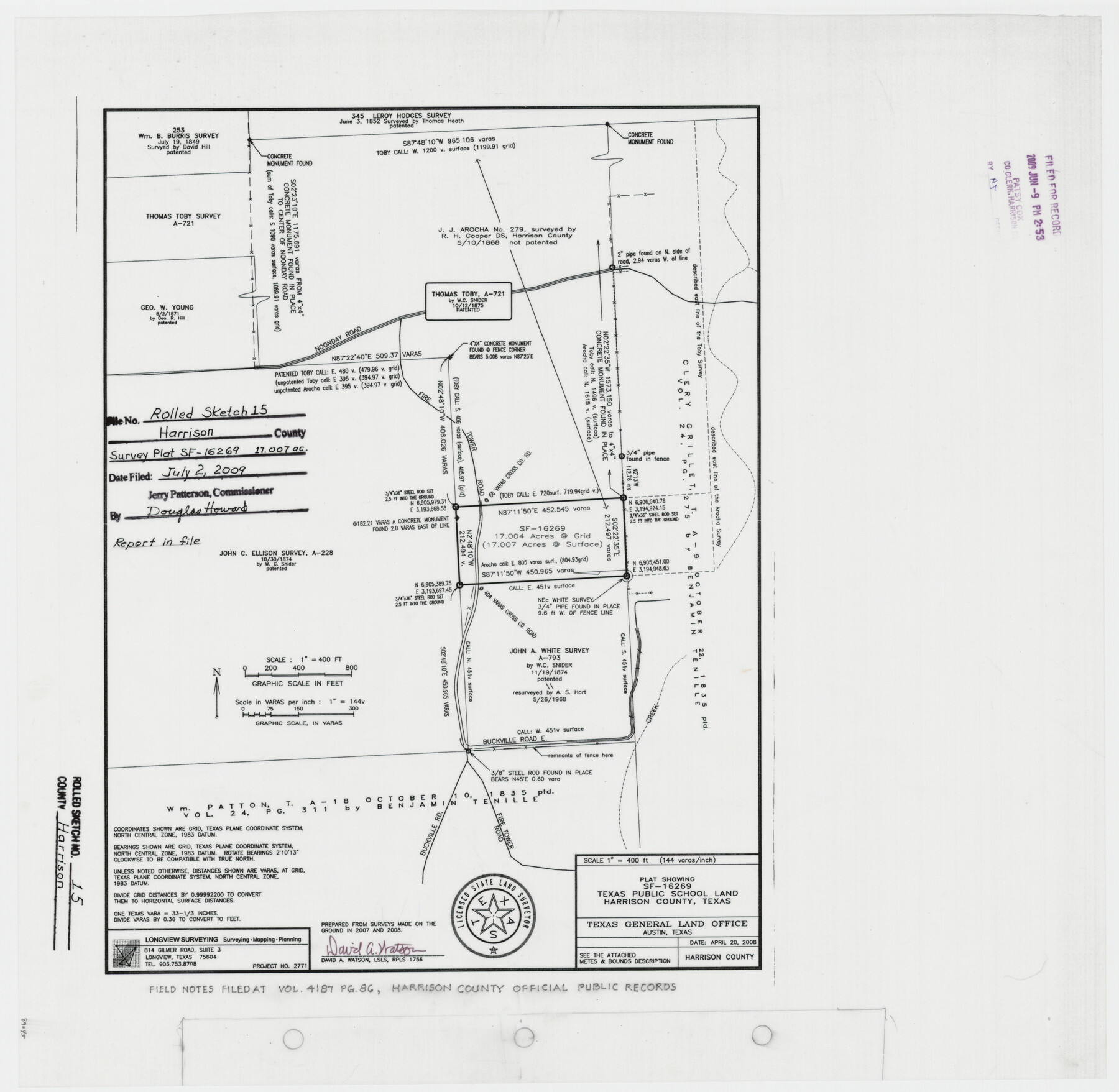
Harrison County Rolled Sketch 15
Plat showing SF-16269, Texas Public School Land, Harrison County, Texas
-
Map/Doc
89045
-
Collection
General Map Collection
-
Object Dates
2008/4/20 (Creation Date)
2009/7/2 (File Date)
-
People and Organizations
David A. Watson (Surveyor/Engineer)
-
Counties
Harrison
-
Subjects
Surveying Rolled Sketch
-
Height x Width
20.5 x 21.0 inches
52.1 x 53.3 cm
-
Medium
mylar, print
-
Scale
1" = 144 varas
Part of: General Map Collection
Anderson County Working Sketch 16

Print $20.00
- Digital $50.00
Anderson County Working Sketch 16
1938
Size 42.4 x 37.1 inches
Map/Doc 67016
Map showing survey for proposed ship channel from Brownsville to Brazos Santiago Pass

Print $20.00
- Digital $50.00
Map showing survey for proposed ship channel from Brownsville to Brazos Santiago Pass
1912
Size 18.4 x 28.4 inches
Map/Doc 72900
Irion County Rolled Sketch 24

Print $40.00
- Digital $50.00
Irion County Rolled Sketch 24
Size 49.4 x 37.4 inches
Map/Doc 9257
Childress County Boundary File 3

Print $48.00
- Digital $50.00
Childress County Boundary File 3
Size 9.4 x 4.5 inches
Map/Doc 51330
Anderson County Rolled Sketch 13

Print $20.00
- Digital $50.00
Anderson County Rolled Sketch 13
1964
Size 19.8 x 32.2 inches
Map/Doc 77158
Flight Mission No. DAG-23K, Frame 166, Matagorda County

Print $20.00
- Digital $50.00
Flight Mission No. DAG-23K, Frame 166, Matagorda County
1953
Size 15.9 x 19.1 inches
Map/Doc 86504
Hill County Sketch File 8a

Print $4.00
- Digital $50.00
Hill County Sketch File 8a
1858
Size 10.2 x 8.1 inches
Map/Doc 26474
Live Oak County Sketch File 28

Print $10.00
- Digital $50.00
Live Oak County Sketch File 28
1922
Size 14.3 x 8.5 inches
Map/Doc 30314
Medina County Working Sketch 24

Print $20.00
- Digital $50.00
Medina County Working Sketch 24
1984
Size 26.1 x 36.7 inches
Map/Doc 70939
Jefferson County Rolled Sketch 40

Print $20.00
- Digital $50.00
Jefferson County Rolled Sketch 40
1957
Size 22.6 x 36.7 inches
Map/Doc 6398

Oldham County Working Sketch 6

Print $40.00
- Digital $50.00
Oldham County Working Sketch 6
1981
Size 32.4 x 50.4 inches
Map/Doc 71328
You may also like
Lubbock County, Texas

Print $20.00
- Digital $50.00
Lubbock County, Texas
1892
Size 27.8 x 22.6 inches
Map/Doc 565
Clay County Rolled Sketch 1

Print $20.00
- Digital $50.00
Clay County Rolled Sketch 1
1940
Size 47.0 x 37.9 inches
Map/Doc 8621

Maverick County Sketch File 21

Print $32.00
- Digital $50.00
Maverick County Sketch File 21
Size 12.6 x 8.1 inches
Map/Doc 31130
Baylor County Sketch File 7

Print $4.00
- Digital $50.00
Baylor County Sketch File 7
Size 6.7 x 10.2 inches
Map/Doc 14135
Map of a part of Laguna Madre in Willacy & Cameron Counties showing subdivision for mineral development

Print $20.00
- Digital $50.00
Map of a part of Laguna Madre in Willacy & Cameron Counties showing subdivision for mineral development
1950
Size 46.9 x 37.0 inches
Map/Doc 3097
[Map of] North America
![88884, [Map of] North America, General Map Collection](https://historictexasmaps.com/wmedia_w700/maps/88884.tif.jpg)
Print $3.00
- Digital $50.00
[Map of] North America
1834
Size 11.0 x 8.5 inches
Map/Doc 88884
Intracoastal Waterway in Texas - Corpus Christi to Point Isabel including Arroyo Colorado to Mo. Pac. R.R. Bridge Near Harlingen

Print $20.00
- Digital $50.00
Intracoastal Waterway in Texas - Corpus Christi to Point Isabel including Arroyo Colorado to Mo. Pac. R.R. Bridge Near Harlingen
1934
Size 21.6 x 32.7 inches
Map/Doc 61879
Panola County Working Sketch 19

Print $40.00
- Digital $50.00
Panola County Working Sketch 19
1945
Map/Doc 71428
Flight Mission No. CRC-3R, Frame 102, Chambers County

Print $20.00
- Digital $50.00
Flight Mission No. CRC-3R, Frame 102, Chambers County
1956
Size 18.7 x 22.5 inches
Map/Doc 84840
Maps of Gulf Intracoastal Waterway, Texas - Sabine River to the Rio Grande and connecting waterways including ship channels

Print $20.00
- Digital $50.00
Maps of Gulf Intracoastal Waterway, Texas - Sabine River to the Rio Grande and connecting waterways including ship channels
1966
Size 14.6 x 20.5 inches
Map/Doc 62000
Marion County Sketch File 3

Print $8.00
- Digital $50.00
Marion County Sketch File 3
1860
Size 14.1 x 8.8 inches
Map/Doc 30566