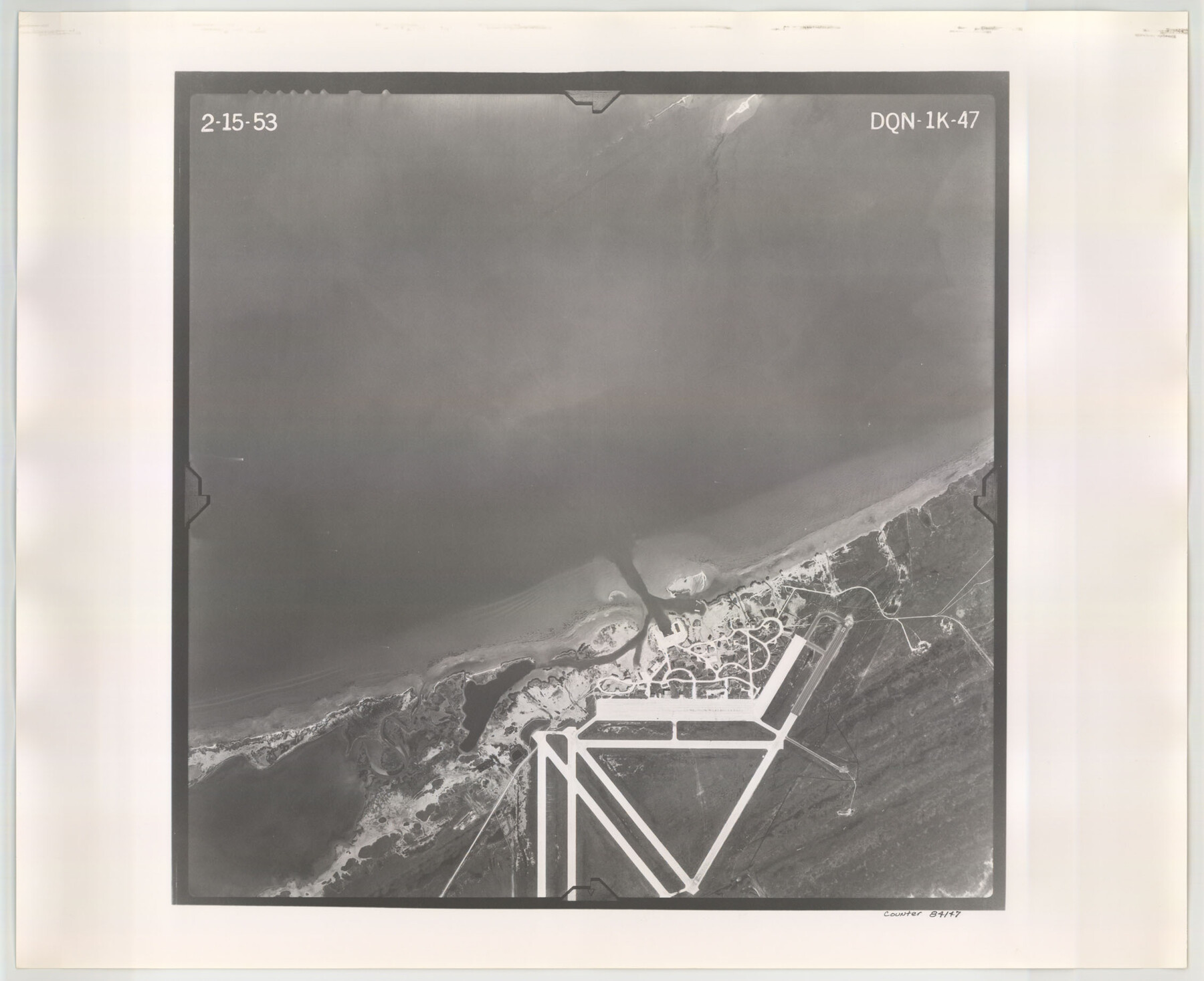
Flight Mission No. DQN-1K, Frame 47, Calhoun County
DQN-1K-47
-
Map/Doc
84147
-
Collection
General Map Collection
-
Object Dates
1953/2/15 (Creation Date)
-
People and Organizations
U. S. Department of Agriculture (Publisher)
-
Counties
Calhoun
-
Subjects
Aerial Photograph
-
Height x Width
18.4 x 22.6 inches
46.7 x 57.4 cm
-
Comments
Flown by Aero Exploration Company of Tulsa, Oklahoma.
Part of: General Map Collection
[Rosebud Station Map - Tracks and Structures - Lands, San Antonio and Aransas Pass Railway Co.]
![62566, [Rosebud Station Map - Tracks and Structures - Lands, San Antonio and Aransas Pass Railway Co.], General Map Collection](https://historictexasmaps.com/wmedia_w700/maps/62566.tif.jpg)
Print $4.00
- Digital $50.00
[Rosebud Station Map - Tracks and Structures - Lands, San Antonio and Aransas Pass Railway Co.]
1919
Size 11.7 x 18.6 inches
Map/Doc 62566
Nueces County Sketch File 10

Print $4.00
- Digital $50.00
Nueces County Sketch File 10
Size 8.2 x 10.1 inches
Map/Doc 32516
Shelby County Sketch File 28

Print $4.00
- Digital $50.00
Shelby County Sketch File 28
Size 6.2 x 7.9 inches
Map/Doc 36664
Waller County Sketch File 6

Print $12.00
- Digital $50.00
Waller County Sketch File 6
Size 13.1 x 6.3 inches
Map/Doc 39602
Roberts County Working Sketch 37

Print $20.00
- Digital $50.00
Roberts County Working Sketch 37
1978
Size 26.6 x 22.5 inches
Map/Doc 63563
J No. 4 - Reconnaissance of Catalina Harbor And the Anchorage on the N.E. Side of the Island, California

Print $20.00
- Digital $50.00
J No. 4 - Reconnaissance of Catalina Harbor And the Anchorage on the N.E. Side of the Island, California
1852
Size 18.3 x 13.1 inches
Map/Doc 97231
Flight Mission No. DIX-6P, Frame 122, Aransas County

Print $20.00
- Digital $50.00
Flight Mission No. DIX-6P, Frame 122, Aransas County
1956
Size 19.1 x 22.4 inches
Map/Doc 83828
Lipscomb County Working Sketch 8

Print $20.00
- Digital $50.00
Lipscomb County Working Sketch 8
1982
Size 42.7 x 23.6 inches
Map/Doc 70584
Rusk County Sketch File 43

Print $20.00
Rusk County Sketch File 43
1951
Size 23.5 x 26.6 inches
Map/Doc 12278
Maps of Gulf Intracoastal Waterway, Texas - Sabine River to the Rio Grande and connecting waterways including ship channels

Print $20.00
- Digital $50.00
Maps of Gulf Intracoastal Waterway, Texas - Sabine River to the Rio Grande and connecting waterways including ship channels
1966
Size 14.5 x 22.3 inches
Map/Doc 61923
Floyd County Working Sketch 2

Print $20.00
- Digital $50.00
Floyd County Working Sketch 2
1911
Size 41.0 x 24.8 inches
Map/Doc 69181
Brazos Santiago, Texas

Print $20.00
- Digital $50.00
Brazos Santiago, Texas
1900
Size 18.3 x 26.9 inches
Map/Doc 73031
You may also like
Jim Hogg County Rolled Sketch F

Print $20.00
- Digital $50.00
Jim Hogg County Rolled Sketch F
1930
Size 24.5 x 28.9 inches
Map/Doc 6445
Dimmit County Rolled Sketch 2

Print $20.00
- Digital $50.00
Dimmit County Rolled Sketch 2
Size 33.9 x 39.6 inches
Map/Doc 8793
Mills County Sketch File 1A

Print $20.00
- Digital $50.00
Mills County Sketch File 1A
1852
Size 33.6 x 20.1 inches
Map/Doc 12092
Runnels County Sketch File 25

Print $20.00
Runnels County Sketch File 25
1940
Size 16.5 x 16.7 inches
Map/Doc 12259
Starr County Sketch File 35

Print $24.00
- Digital $50.00
Starr County Sketch File 35
1939
Size 14.3 x 8.8 inches
Map/Doc 36974
Baylor County Sketch File 4

Print $4.00
- Digital $50.00
Baylor County Sketch File 4
1872
Size 12.8 x 8.3 inches
Map/Doc 14126
Jack County Working Sketch 16

Print $20.00
- Digital $50.00
Jack County Working Sketch 16
1982
Size 25.7 x 25.7 inches
Map/Doc 66442
Township 3 South Range 12 West, South Western District, Louisiana

Print $20.00
- Digital $50.00
Township 3 South Range 12 West, South Western District, Louisiana
1879
Size 19.5 x 24.8 inches
Map/Doc 65883
Concho County Sketch File 35

Print $20.00
- Digital $50.00
Concho County Sketch File 35
1937
Size 14.9 x 15.5 inches
Map/Doc 11160
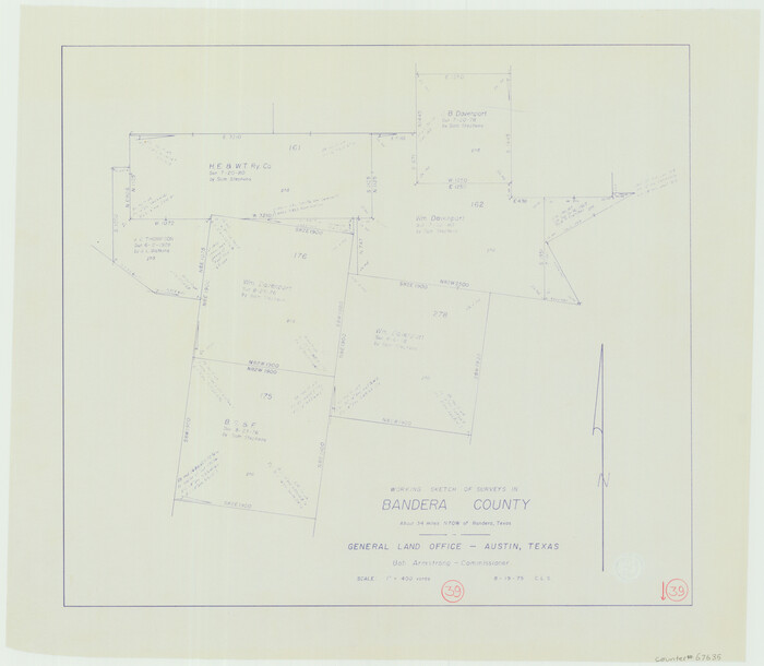
Bandera County Working Sketch 39
Print $20.00
- Digital $50.00
Bandera County Working Sketch 39
1975
Size 22.1 x 25.3 inches
Map/Doc 67635
Llano County Sketch File 3

Print $6.00
- Digital $50.00
Llano County Sketch File 3
1874
Size 8.0 x 8.9 inches
Map/Doc 30350
[Central Garza County]
![92659, [Central Garza County], Twichell Survey Records](https://historictexasmaps.com/wmedia_w700/maps/92659-1.tif.jpg)
Print $20.00
- Digital $50.00
[Central Garza County]
1906
Size 28.0 x 33.1 inches
Map/Doc 92659