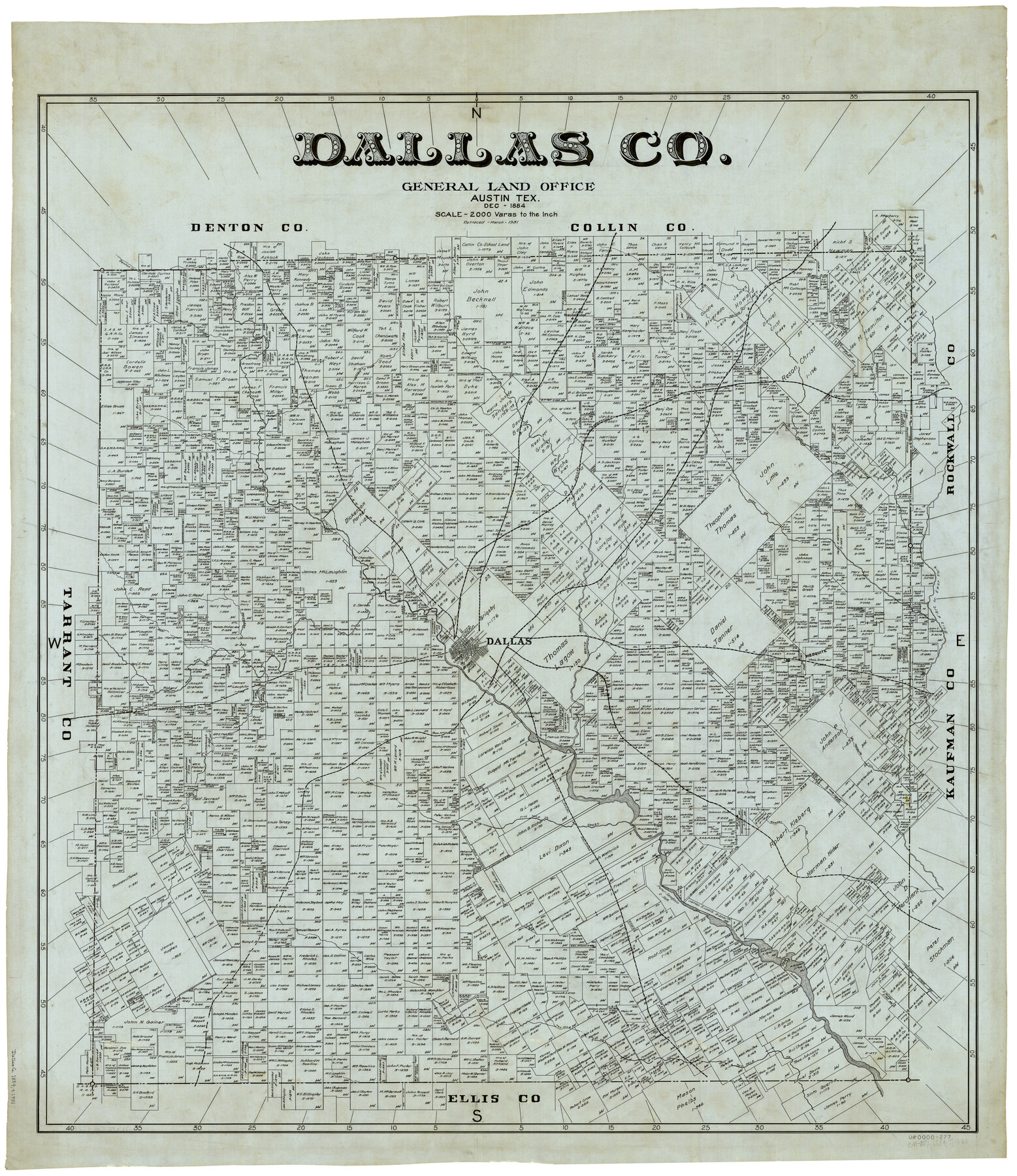
Dallas Co.
-
Map/Doc
4928
-
Collection
General Map Collection
-
Object Dates
12/1884 (Creation Date)
-
Counties
Dallas
-
Subjects
County
-
Height x Width
40.4 x 36.5 inches
102.6 x 92.7 cm
-
Comments
Retraced in March 1931.
Part of: General Map Collection
Hardin County Working Sketch 25

Print $20.00
- Digital $50.00
Hardin County Working Sketch 25
1950
Size 10.8 x 20.1 inches
Map/Doc 63423
Presidio County Working Sketch 46

Print $40.00
- Digital $50.00
Presidio County Working Sketch 46
1947
Size 36.8 x 59.0 inches
Map/Doc 71723
Montgomery County Sketch File 40

Print $8.00
- Digital $50.00
Montgomery County Sketch File 40
1914
Size 11.3 x 8.8 inches
Map/Doc 31925
Crane County Sketch File 13b

Print $40.00
- Digital $50.00
Crane County Sketch File 13b
1901
Size 11.4 x 13.8 inches
Map/Doc 19573
Grimes County Working Sketch 8

Print $20.00
- Digital $50.00
Grimes County Working Sketch 8
1976
Size 35.0 x 32.7 inches
Map/Doc 63299
Wharton County Working Sketch 3

Print $20.00
- Digital $50.00
Wharton County Working Sketch 3
Size 17.5 x 16.4 inches
Map/Doc 72467
Duval County Rolled Sketch 30A

Print $40.00
- Digital $50.00
Duval County Rolled Sketch 30A
1896
Size 59.7 x 40.8 inches
Map/Doc 76145
Clay County Sketch File 47

Print $6.00
- Digital $50.00
Clay County Sketch File 47
Size 11.3 x 17.4 inches
Map/Doc 18485
Fort Bend County Rolled Sketch B

Print $20.00
- Digital $50.00
Fort Bend County Rolled Sketch B
Size 20.4 x 28.9 inches
Map/Doc 5904
Galveston Bay

Print $20.00
- Digital $50.00
Galveston Bay
1907
Size 40.6 x 34.4 inches
Map/Doc 69871
Outer Continental Shelf Leasing Maps (Texas Offshore Operations)

Print $20.00
- Digital $50.00
Outer Continental Shelf Leasing Maps (Texas Offshore Operations)
1954
Size 14.6 x 15.6 inches
Map/Doc 75836
Delta County Working Sketch 1

Print $20.00
- Digital $50.00
Delta County Working Sketch 1
1942
Size 24.7 x 28.8 inches
Map/Doc 68638
You may also like

Flight Mission No. BRA-16M, Frame 144, Jefferson County

Print $20.00
- Digital $50.00
Flight Mission No. BRA-16M, Frame 144, Jefferson County
1953
Size 18.6 x 22.5 inches
Map/Doc 85750
Flight Mission No. DQO-8K, Frame 8, Galveston County

Print $20.00
- Digital $50.00
Flight Mission No. DQO-8K, Frame 8, Galveston County
1952
Size 18.8 x 22.5 inches
Map/Doc 85131
Coast Chart No. 210 Aransas Pass and Corpus Christi Bay with the coast to latitude 27° 12' Texas

Print $20.00
- Digital $50.00
Coast Chart No. 210 Aransas Pass and Corpus Christi Bay with the coast to latitude 27° 12' Texas
1913
Size 27.0 x 18.2 inches
Map/Doc 72800
Randall County Rolled Sketch 10

Print $20.00
- Digital $50.00
Randall County Rolled Sketch 10
Size 26.9 x 22.6 inches
Map/Doc 7431
Sabine County Sketch File 6b

Print $4.00
Sabine County Sketch File 6b
1879
Size 8.1 x 9.0 inches
Map/Doc 35617
Gaines County Working Sketch 31

Print $20.00
- Digital $50.00
Gaines County Working Sketch 31
1990
Size 37.4 x 26.8 inches
Map/Doc 69331
Travis County Sketch File 76

Print $68.00
- Digital $50.00
Travis County Sketch File 76
1996
Size 11.4 x 8.9 inches
Map/Doc 38474
Jefferson County Sketch File 50

Print $5.00
- Digital $50.00
Jefferson County Sketch File 50
1841
Size 8.2 x 9.7 inches
Map/Doc 28247
Stonewall County Sketch File 25

Print $7.00
- Digital $50.00
Stonewall County Sketch File 25
1952
Size 26.7 x 43.3 inches
Map/Doc 10375
Blanco County Working Sketch 33

Print $40.00
- Digital $50.00
Blanco County Working Sketch 33
1978
Size 41.0 x 57.5 inches
Map/Doc 67393
Reagan County Rolled Sketch 20

Print $20.00
- Digital $50.00
Reagan County Rolled Sketch 20
1948
Size 45.8 x 45.0 inches
Map/Doc 9814