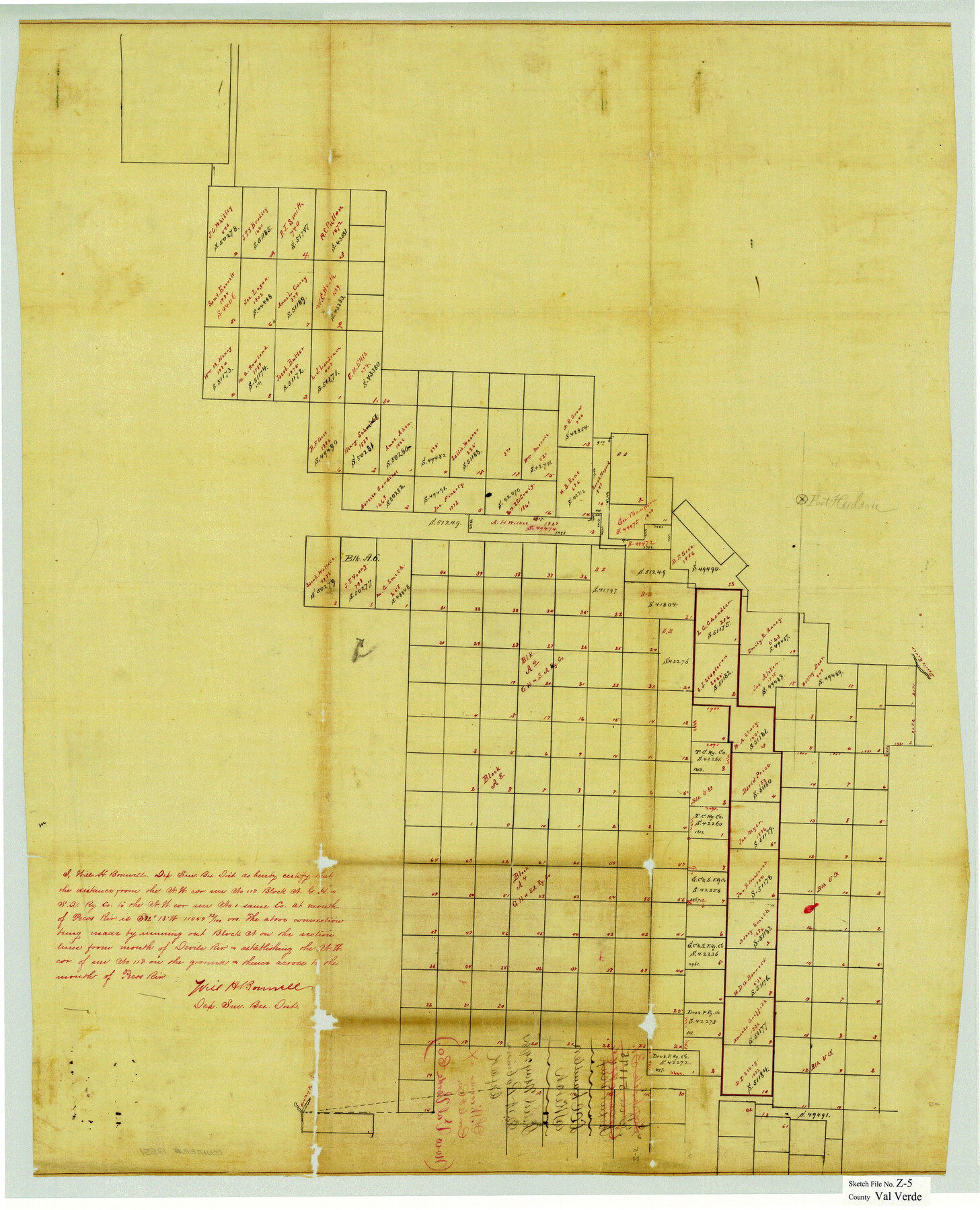
Val Verde County Sketch File Z5
[Sketch of surveys in Block A4 and surrounding area northwest from Del Rio]
-
Map/Doc
12551
-
Collection
General Map Collection
-
Object Dates
5/29/1884 (File Date)
-
People and Organizations
Will H. Bonnell (Surveyor/Engineer)
-
Counties
Val Verde
-
Subjects
Surveying Sketch File
-
Height x Width
32.3 x 26.1 inches
82.0 x 66.3 cm
-
Medium
paper, manuscript
-
Features
Fort Hudson
Pecos River
Devil's River
Part of: General Map Collection

[Surveys along the Colorado River]
![119, [Surveys along the Colorado River], General Map Collection](https://historictexasmaps.com/wmedia_w700/maps/119.tif.jpg)
Print $20.00
- Digital $50.00
[Surveys along the Colorado River]
1840
Size 23.8 x 17.9 inches
Map/Doc 119
Map of Goliad County Texas

Print $20.00
- Digital $50.00
Map of Goliad County Texas
1879
Size 19.5 x 21.8 inches
Map/Doc 4548
Flight Mission No. DQN-5K, Frame 28, Calhoun County

Print $20.00
- Digital $50.00
Flight Mission No. DQN-5K, Frame 28, Calhoun County
1953
Size 18.5 x 22.1 inches
Map/Doc 84379
Midland County Working Sketch 13

Print $40.00
- Digital $50.00
Midland County Working Sketch 13
1951
Size 24.3 x 48.5 inches
Map/Doc 70993
Gaines County Working Sketch 16

Print $20.00
- Digital $50.00
Gaines County Working Sketch 16
1959
Size 42.4 x 37.3 inches
Map/Doc 69316
Nueces County Sketch File 4

Print $4.00
- Digital $50.00
Nueces County Sketch File 4
1848
Size 10.1 x 8.0 inches
Map/Doc 32505
Map of Nacogdoches County

Print $20.00
- Digital $50.00
Map of Nacogdoches County
1881
Size 24.1 x 21.5 inches
Map/Doc 3909
Part of Laguna Madre in Kenedy and Willacy Counties, showing Subdivision for Mineral Development

Print $40.00
- Digital $50.00
Part of Laguna Madre in Kenedy and Willacy Counties, showing Subdivision for Mineral Development
1946
Size 49.1 x 30.0 inches
Map/Doc 1924
Ector County Working Sketch 30

Print $40.00
- Digital $50.00
Ector County Working Sketch 30
1971
Size 43.2 x 64.1 inches
Map/Doc 68873
Sabine Bank to East Bay including Heald Bank

Print $20.00
- Digital $50.00
Sabine Bank to East Bay including Heald Bank
1960
Size 45.1 x 34.3 inches
Map/Doc 69847
Map of Freestone County

Print $20.00
- Digital $50.00
Map of Freestone County
1858
Size 22.3 x 24.1 inches
Map/Doc 3564
You may also like
Flight Mission No. DIX-5P, Frame 146, Aransas County

Print $20.00
- Digital $50.00
Flight Mission No. DIX-5P, Frame 146, Aransas County
1956
Size 17.7 x 17.9 inches
Map/Doc 83808
Clay County Sketch File 48

Print $26.00
- Digital $50.00
Clay County Sketch File 48
1919
Size 14.2 x 8.6 inches
Map/Doc 18487
Copy of Surveyor's Field Book, Morris Browning - In Blocks 7, 5 & 4, I&GNRRCo., Hutchinson and Carson Counties, Texas

Print $2.00
- Digital $50.00
Copy of Surveyor's Field Book, Morris Browning - In Blocks 7, 5 & 4, I&GNRRCo., Hutchinson and Carson Counties, Texas
1888
Size 7.0 x 8.8 inches
Map/Doc 62286
Comal County Working Sketch 1

Print $20.00
- Digital $50.00
Comal County Working Sketch 1
1919
Size 22.1 x 18.2 inches
Map/Doc 68167
El Paso County Working Sketch 56

Print $40.00
- Digital $50.00
El Paso County Working Sketch 56
1971
Size 65.7 x 43.4 inches
Map/Doc 69078

Crockett County Rolled Sketch 77

Print $20.00
- Digital $50.00
Crockett County Rolled Sketch 77
1952
Size 26.9 x 28.6 inches
Map/Doc 5618
[Surveys along Meridian Creek]
![242, [Surveys along Meridian Creek], General Map Collection](https://historictexasmaps.com/wmedia_w700/maps/242.tif.jpg)
Print $2.00
- Digital $50.00
[Surveys along Meridian Creek]
1846
Size 6.4 x 7.7 inches
Map/Doc 242
Flight Mission No. CGI-3N, Frame 120, Cameron County

Print $20.00
- Digital $50.00
Flight Mission No. CGI-3N, Frame 120, Cameron County
1954
Size 18.8 x 22.3 inches
Map/Doc 84593
Ward County Rolled Sketch 17

Print $20.00
- Digital $50.00
Ward County Rolled Sketch 17
1947
Size 16.2 x 19.5 inches
Map/Doc 8160
Red River County Working Sketch 28

Print $20.00
- Digital $50.00
Red River County Working Sketch 28
1961
Size 28.1 x 38.7 inches
Map/Doc 72011
Flight Mission No. BRA-8M, Frame 77, Jefferson County

Print $20.00
- Digital $50.00
Flight Mission No. BRA-8M, Frame 77, Jefferson County
1953
Size 15.9 x 15.7 inches
Map/Doc 85597