Leon County Rolled Sketch 17
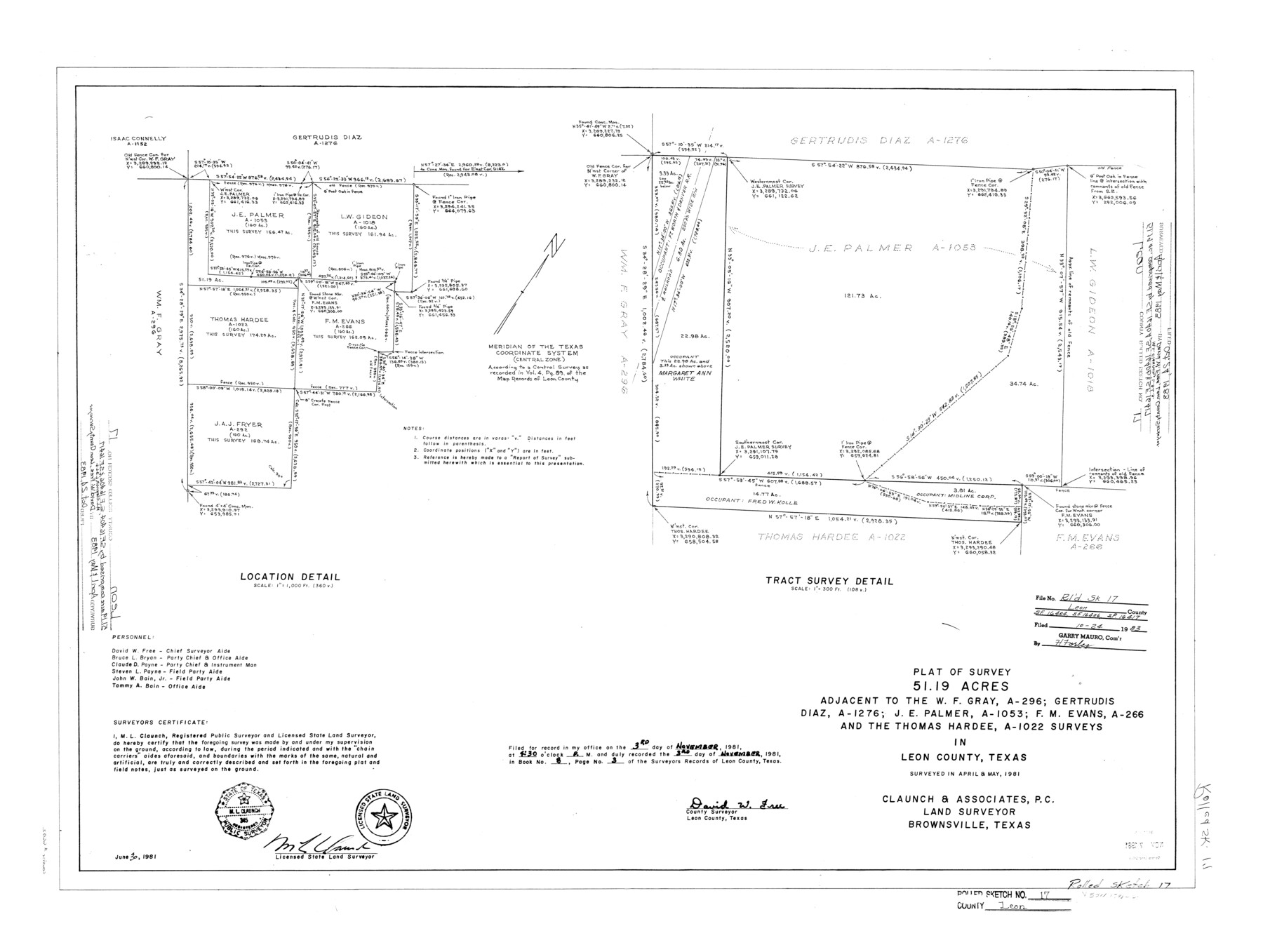
Plat of survey 51.19 acres adjacent to the W.F. Gray, A-296; Gertrudis Diaz, A-1276; J.E. Palmer, A-1053; F.M. Evans, A-266 and the Thomas Hardee, A-1022 surveys in Leon County, Texas
-
Map/Doc
6602
-
Collection
General Map Collection
-
Object Dates
1981 (Survey Date)
1983/10/24 (File Date)
1981/6/30 (Creation Date)
-
People and Organizations
David W. Free (Chainman/Field Personnel)
Bruce L. Bryan (Chainman/Field Personnel)
Claude D. Payne (Chainman/Field Personnel)
Steven L. Payne (Chainman/Field Personnel)
John W. Bain, Jr. (Chainman/Field Personnel)
Tammy A. Bain (Chainman/Field Personnel)
M.L. Claunch (Surveyor/Engineer)
-
Counties
Leon
-
Subjects
Surveying Rolled Sketch
-
Height x Width
25.2 x 33.4 inches
64.0 x 84.8 cm
-
Medium
mylar, print
-
Scale
1" = 360 varas
Part of: General Map Collection

Reagan County Sketch File 20

Print $4.00
- Digital $50.00
Reagan County Sketch File 20
Size 14.5 x 9.0 inches
Map/Doc 35011
Flight Mission No. DIX-5P, Frame 144, Aransas County

Print $20.00
- Digital $50.00
Flight Mission No. DIX-5P, Frame 144, Aransas County
1956
Size 17.2 x 17.6 inches
Map/Doc 83805
Flight Mission No. DCL-3C, Frame 105, Kenedy County

Print $20.00
- Digital $50.00
Flight Mission No. DCL-3C, Frame 105, Kenedy County
1943
Size 18.6 x 22.2 inches
Map/Doc 85800
Maps of Gulf Intracoastal Waterway, Texas - Sabine River to the Rio Grande and connecting waterways including ship channels

Print $20.00
- Digital $50.00
Maps of Gulf Intracoastal Waterway, Texas - Sabine River to the Rio Grande and connecting waterways including ship channels
1966
Size 14.2 x 20.7 inches
Map/Doc 61997
Kinney County Sketch File 31

Print $40.00
- Digital $50.00
Kinney County Sketch File 31
1934
Size 15.3 x 13.6 inches
Map/Doc 29176
Ochiltree County Boundary File 6

Print $4.00
- Digital $50.00
Ochiltree County Boundary File 6
Size 11.1 x 8.6 inches
Map/Doc 57713
Castro County

Print $20.00
- Digital $50.00
Castro County
1932
Size 43.4 x 38.6 inches
Map/Doc 73102
Aransas County Sketch File 21b

Print $4.00
- Digital $50.00
Aransas County Sketch File 21b
Size 8.7 x 14.2 inches
Map/Doc 13160
Gaines County Rolled Sketch 24

Print $20.00
- Digital $50.00
Gaines County Rolled Sketch 24
1965
Size 41.8 x 31.3 inches
Map/Doc 9314
Lampasas County Working Sketch 22

Print $20.00
- Digital $50.00
Lampasas County Working Sketch 22
1993
Size 34.5 x 34.7 inches
Map/Doc 70300
San Patricio County NRC Article 33.136 Sketch 9

Print $82.00
San Patricio County NRC Article 33.136 Sketch 9
2022
Map/Doc 97031
You may also like
Flight Mission No. DAG-14K, Frame 132, Matagorda County

Print $20.00
- Digital $50.00
Flight Mission No. DAG-14K, Frame 132, Matagorda County
1952
Size 17.6 x 17.5 inches
Map/Doc 86303
Pecos County Working Sketch 83

Print $20.00
- Digital $50.00
Pecos County Working Sketch 83
1961
Size 18.7 x 28.7 inches
Map/Doc 71555
Dickens County Working Sketch 4

Print $20.00
- Digital $50.00
Dickens County Working Sketch 4
1914
Size 27.9 x 18.8 inches
Map/Doc 68651
[Map of Encinal County]
![3517, [Map of Encinal County], General Map Collection](https://historictexasmaps.com/wmedia_w700/maps/3517-1.tif.jpg)
Print $20.00
- Digital $50.00
[Map of Encinal County]
1872
Size 27.9 x 21.9 inches
Map/Doc 3517
[Surveys along the Sabine River made under G.W. Smyth, Commissioner]
![89, [Surveys along the Sabine River made under G.W. Smyth, Commissioner], General Map Collection](https://historictexasmaps.com/wmedia_w700/maps/89.tif.jpg)
Print $20.00
- Digital $50.00
[Surveys along the Sabine River made under G.W. Smyth, Commissioner]
Size 12.6 x 17.1 inches
Map/Doc 89
Webb County Rolled Sketch 9

Print $20.00
- Digital $50.00
Webb County Rolled Sketch 9
1905
Size 12.6 x 16.3 inches
Map/Doc 8175
Map of Copano, St. Charles, Aransas & Red Fish Bays in Aransas & Nueces Counties showing subdivision thereof for Mineral Development

Print $20.00
- Digital $50.00
Map of Copano, St. Charles, Aransas & Red Fish Bays in Aransas & Nueces Counties showing subdivision thereof for Mineral Development
1948
Size 35.9 x 34.0 inches
Map/Doc 2923
Zavala County Sketch File 40

Print $20.00
- Digital $50.00
Zavala County Sketch File 40
1901
Size 14.4 x 8.9 inches
Map/Doc 41406
Hemphill County Working Sketch 28

Print $40.00
- Digital $50.00
Hemphill County Working Sketch 28
1974
Size 61.8 x 43.5 inches
Map/Doc 66123
Taylor County Sketch File 12

Print $4.00
- Digital $50.00
Taylor County Sketch File 12
Size 8.6 x 12.8 inches
Map/Doc 37796
Gaines County Working Sketch 11

Print $40.00
- Digital $50.00
Gaines County Working Sketch 11
1953
Size 68.4 x 33.4 inches
Map/Doc 69311
Neue Karte de Staates Texas für 1881.

Print $20.00
Neue Karte de Staates Texas für 1881.
1881
Size 19.3 x 25.6 inches
Map/Doc 93573