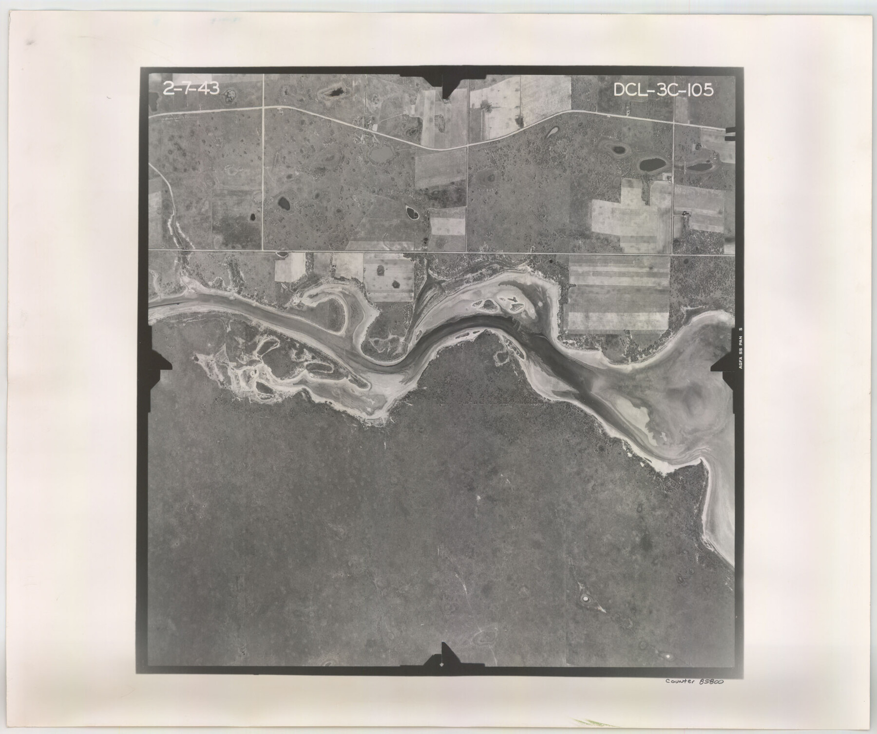
Flight Mission No. DCL-3C, Frame 105, Kenedy County
DCL-3C-105
-
Map/Doc
85800
-
Collection
General Map Collection
-
Object Dates
1943/2/7 (Creation Date)
-
People and Organizations
U. S. Department of Agriculture (Publisher)
-
Counties
Kenedy
-
Subjects
Aerial Photograph
-
Height x Width
18.6 x 22.2 inches
47.2 x 56.4 cm
-
Comments
Flown by Aerial Surveys of Pittsburgh, Inc. of Pittsburgh, Pennsylvania.
Part of: General Map Collection
Tarrant County State Real Property Sketch 4

Print $20.00
- Digital $50.00
Tarrant County State Real Property Sketch 4
2018
Size 47.8 x 35.9 inches
Map/Doc 95403
Map of the Recognised Line M. EL. P. & P. R. R. from East Line of Bexar Land District to El Paso

Print $40.00
- Digital $50.00
Map of the Recognised Line M. EL. P. & P. R. R. from East Line of Bexar Land District to El Paso
1857
Size 20.0 x 50.4 inches
Map/Doc 85322
San Saba County Sketch File 18

Print $12.00
- Digital $50.00
San Saba County Sketch File 18
1919
Size 11.4 x 8.8 inches
Map/Doc 36460
Galveston to Rio Grande

Print $20.00
- Digital $50.00
Galveston to Rio Grande
1946
Size 44.8 x 36.9 inches
Map/Doc 69953
Lamar County Sketch File 3

Print $6.00
- Digital $50.00
Lamar County Sketch File 3
1864
Size 14.2 x 8.6 inches
Map/Doc 29275
Jasper County Working Sketch 5

Print $20.00
- Digital $50.00
Jasper County Working Sketch 5
1906
Size 26.8 x 38.0 inches
Map/Doc 66467
Cochran County Rolled Sketch A

Print $40.00
- Digital $50.00
Cochran County Rolled Sketch A
Size 28.5 x 55.3 inches
Map/Doc 8604
Texas Highway Map Points of Interest, Recreational Facilities Guide, Special Events Calendar [Recto]
![94187, Texas Highway Map Points of Interest, Recreational Facilities Guide, Special Events Calendar [Recto], General Map Collection](https://historictexasmaps.com/wmedia_w700/maps/94187.tif.jpg)
Texas Highway Map Points of Interest, Recreational Facilities Guide, Special Events Calendar [Recto]
1963
Size 30.9 x 18.2 inches
Map/Doc 94187
McMullen County Sketch File 43

Print $10.00
- Digital $50.00
McMullen County Sketch File 43
1942
Size 14.2 x 8.8 inches
Map/Doc 31421
Oldham County Working Sketch 2

Print $20.00
- Digital $50.00
Oldham County Working Sketch 2
1906
Size 16.1 x 15.1 inches
Map/Doc 71324
Sutton County Working Sketch 12

Print $40.00
- Digital $50.00
Sutton County Working Sketch 12
1972
Size 66.8 x 37.3 inches
Map/Doc 62355
Fayette County Boundary File 7

Print $40.00
- Digital $50.00
Fayette County Boundary File 7
Size 18.1 x 13.1 inches
Map/Doc 53400
You may also like
Kleberg County Rolled Sketch 6

Print $20.00
- Digital $50.00
Kleberg County Rolled Sketch 6
Size 11.1 x 13.0 inches
Map/Doc 9359
Dickens County Sketch File L1

Print $16.00
- Digital $50.00
Dickens County Sketch File L1
1907
Size 9.1 x 7.4 inches
Map/Doc 20903
Louisiana and Texas Intracoastal Waterway - Matagorda-Espiritu Santo and San Antonio Bays, Section 8-9, Survey of 1927-8 - Index Sheet 3

Print $20.00
- Digital $50.00
Louisiana and Texas Intracoastal Waterway - Matagorda-Espiritu Santo and San Antonio Bays, Section 8-9, Survey of 1927-8 - Index Sheet 3
1929
Size 31.0 x 42.8 inches
Map/Doc 61837
[PSL Blks. A55, A56, 77, B1, B2, B6 and and B10]
![89821, [PSL Blks. A55, A56, 77, B1, B2, B6 and and B10], Twichell Survey Records](https://historictexasmaps.com/wmedia_w700/maps/89821-1.tif.jpg)
Print $40.00
- Digital $50.00
[PSL Blks. A55, A56, 77, B1, B2, B6 and and B10]
Size 24.0 x 69.3 inches
Map/Doc 89821
Austin and Surrounding Properties
.tif.jpg)
Print $20.00
- Digital $50.00
Austin and Surrounding Properties
1891
Size 42.9 x 32.1 inches
Map/Doc 421
Dickens County Sketch File 33

Print $10.00
- Digital $50.00
Dickens County Sketch File 33
1947
Size 14.5 x 9.1 inches
Map/Doc 21025
Andrews County Rolled Sketch 26

Print $40.00
- Digital $50.00
Andrews County Rolled Sketch 26
1948
Size 78.3 x 13.2 inches
Map/Doc 8398
Clay County Sketch File 9a

Print $6.00
- Digital $50.00
Clay County Sketch File 9a
1855
Size 10.7 x 6.1 inches
Map/Doc 18403
The League Lines, Coastal and Border Reserves, with Surveys

Print $20.00
The League Lines, Coastal and Border Reserves, with Surveys
2020
Size 20.1 x 21.7 inches
Map/Doc 96426
General Highway Map, Johnson County, Texas

Print $20.00
General Highway Map, Johnson County, Texas
1940
Size 18.3 x 24.8 inches
Map/Doc 79149
Harris County

Print $40.00
- Digital $50.00
Harris County
1896
Size 44.8 x 67.5 inches
Map/Doc 66856
The Castro Colony. February 15, 1842

Print $20.00
The Castro Colony. February 15, 1842
2020
Size 23.0 x 17.7 inches
Map/Doc 96357