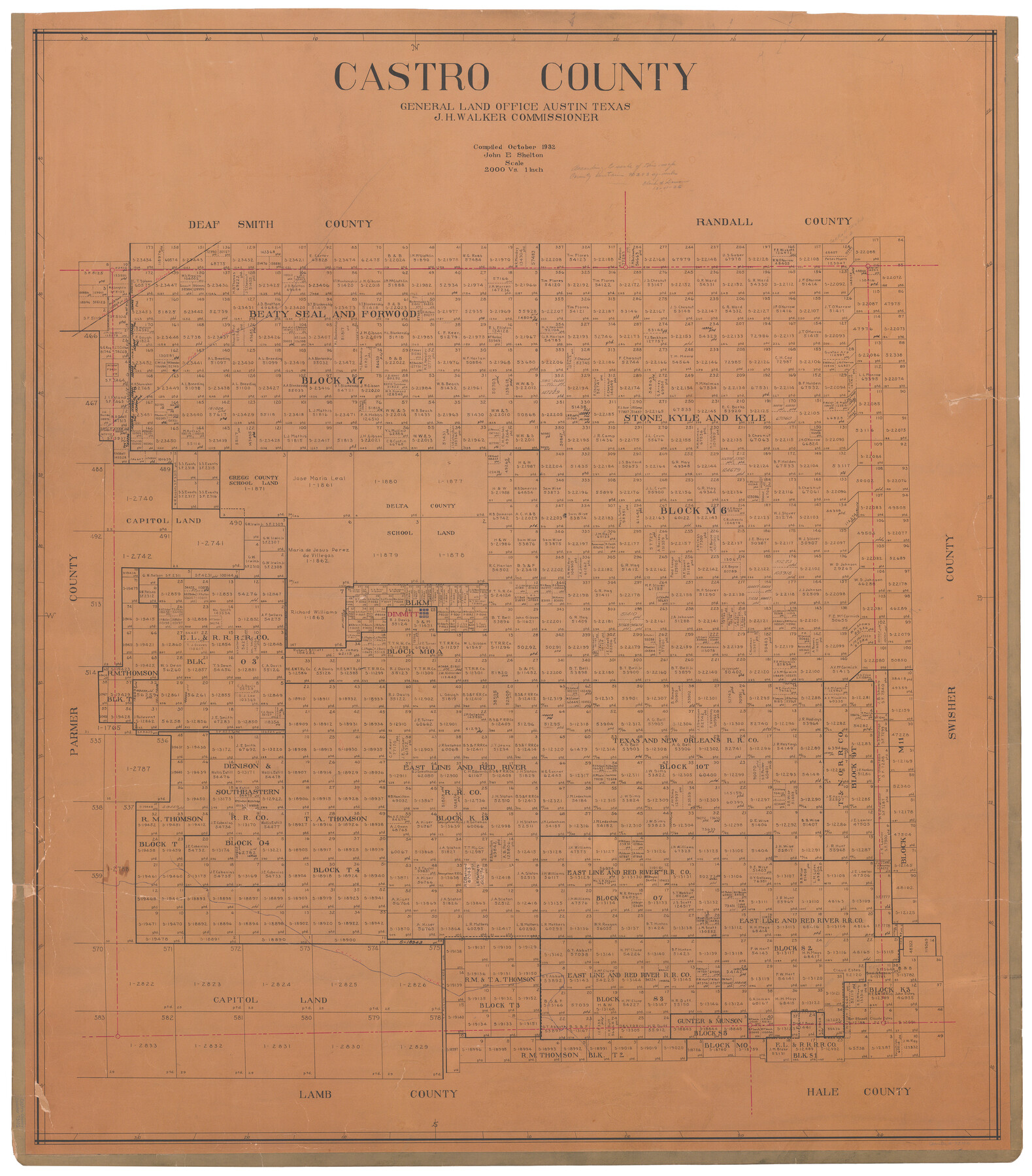
Castro County
-
Map/Doc
73102
-
Collection
General Map Collection
-
Object Dates
1932 (Creation Date)
-
People and Organizations
Texas General Land Office (Publisher)
John E. Shelton Jr. (Compiler)
John E. Shelton Jr. (Draftsman)
J.H. Walker (GLO Commissioner)
-
Counties
Castro
-
Subjects
County
-
Height x Width
43.4 x 38.6 inches
110.2 x 98.0 cm
-
Comments
Hand lettered.
-
Features
P&NT
Frio Creek
Dimmitt
Catfish Creek
Part of: General Map Collection
Cooke County Sketch File 8

Print $4.00
- Digital $50.00
Cooke County Sketch File 8
Size 8.2 x 8.4 inches
Map/Doc 19235
Mitchell County

Print $20.00
- Digital $50.00
Mitchell County
1922
Size 42.6 x 38.3 inches
Map/Doc 2309
Culberson County Sketch File 3

Print $58.00
- Digital $50.00
Culberson County Sketch File 3
Size 8.0 x 3.3 inches
Map/Doc 20112
Red River County Rolled Sketch 5

Print $20.00
- Digital $50.00
Red River County Rolled Sketch 5
Size 33.5 x 32.5 inches
Map/Doc 9842
Pecos County Rolled Sketch 153

Print $20.00
- Digital $50.00
Pecos County Rolled Sketch 153
1960
Size 20.2 x 22.7 inches
Map/Doc 7282
Flight Mission No. DQO-7K, Frame 113, Galveston County

Print $20.00
- Digital $50.00
Flight Mission No. DQO-7K, Frame 113, Galveston County
1952
Size 18.7 x 22.3 inches
Map/Doc 85128
Cass County Rolled Sketch OPD

Print $20.00
- Digital $50.00
Cass County Rolled Sketch OPD
1936
Size 29.4 x 25.1 inches
Map/Doc 5483
Brewster County Rolled Sketch 82A

Print $40.00
- Digital $50.00
Brewster County Rolled Sketch 82A
1952
Size 74.3 x 34.0 inches
Map/Doc 8498
Coleman County Sketch File 20

Print $4.00
- Digital $50.00
Coleman County Sketch File 20
1871
Size 12.9 x 8.0 inches
Map/Doc 18694
Starr County Rolled Sketch 38

Print $40.00
- Digital $50.00
Starr County Rolled Sketch 38
1944
Size 97.9 x 25.0 inches
Map/Doc 10297
Flight Mission No. CRC-2R, Frame 196, Chambers County

Print $20.00
- Digital $50.00
Flight Mission No. CRC-2R, Frame 196, Chambers County
1956
Size 18.7 x 22.4 inches
Map/Doc 84774
Red River County Working Sketch 42

Print $20.00
- Digital $50.00
Red River County Working Sketch 42
1968
Size 28.7 x 36.8 inches
Map/Doc 72025
You may also like
Tom Green County Rolled Sketch 10

Print $20.00
- Digital $50.00
Tom Green County Rolled Sketch 10
1949
Size 26.4 x 32.5 inches
Map/Doc 7997
Map No. 2 - Surveys Corrected in 1882 as they appear on the ground

Print $20.00
- Digital $50.00
Map No. 2 - Surveys Corrected in 1882 as they appear on the ground
1882
Size 30.7 x 19.2 inches
Map/Doc 91925

[Sketch showing Blocks B-11, O-18, P and Mc in case of Laneer vs. Bivens]
![91726, [Sketch showing Blocks B-11, O-18, P and Mc in case of Laneer vs. Bivens], Twichell Survey Records](https://historictexasmaps.com/wmedia_w700/maps/91726-1.tif.jpg)
Print $20.00
- Digital $50.00
[Sketch showing Blocks B-11, O-18, P and Mc in case of Laneer vs. Bivens]
Size 21.2 x 18.6 inches
Map/Doc 91726
Fisher County Working Sketch 5

Print $20.00
- Digital $50.00
Fisher County Working Sketch 5
1926
Size 23.0 x 25.6 inches
Map/Doc 69139
Hutchinson County Rolled Sketch 28

Print $20.00
- Digital $50.00
Hutchinson County Rolled Sketch 28
1921
Size 28.1 x 34.7 inches
Map/Doc 6290
Ector County Working Sketch 19

Print $40.00
- Digital $50.00
Ector County Working Sketch 19
1958
Size 65.8 x 37.6 inches
Map/Doc 68862
Young Territory

Print $20.00
- Digital $50.00
Young Territory
1874
Size 29.4 x 29.2 inches
Map/Doc 1977

Fort Bend County Sketch File 34

Print $20.00
- Digital $50.00
Fort Bend County Sketch File 34
Size 22.3 x 18.0 inches
Map/Doc 11514
[Sketch Showing Connections from Jeremiah McDonald resurvey]
![91154, [Sketch Showing Connections from Jeremiah McDonald resurvey], Twichell Survey Records](https://historictexasmaps.com/wmedia_w700/maps/91154-1.tif.jpg)
Print $20.00
- Digital $50.00
[Sketch Showing Connections from Jeremiah McDonald resurvey]
Size 21.6 x 14.5 inches
Map/Doc 91154
