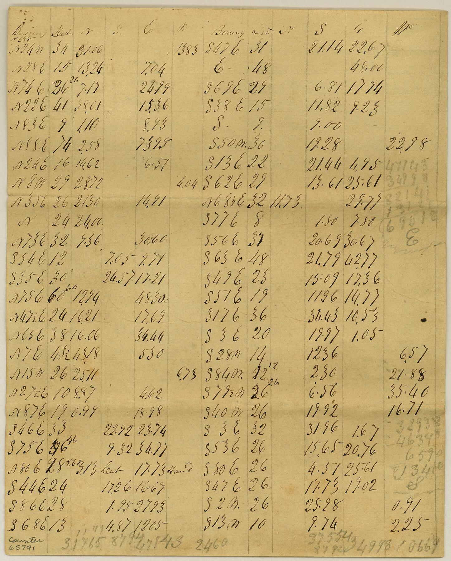
Meanders of Sulphur Fork of Red River, Red River County, Texas
K-3-7
-
Map/Doc
65791
-
Collection
General Map Collection
-
Object Dates
1841 (Creation Date)
-
Counties
Red River
-
Subjects
River Surveys
-
Height x Width
10.0 x 8.0 inches
25.4 x 20.3 cm
Part of: General Map Collection
Liberty County Working Sketch 15

Print $20.00
- Digital $50.00
Liberty County Working Sketch 15
1922
Size 19.0 x 15.0 inches
Map/Doc 70474
Dawson County Working Sketch 6

Print $20.00
- Digital $50.00
Dawson County Working Sketch 6
1939
Size 43.9 x 42.7 inches
Map/Doc 68550
Reagan County Rolled Sketch 29B

Print $20.00
- Digital $50.00
Reagan County Rolled Sketch 29B
1955
Size 36.5 x 36.1 inches
Map/Doc 9826
[Sketch for Mineral Application 13440]
![65674, [Sketch for Mineral Application 13440], General Map Collection](https://historictexasmaps.com/wmedia_w700/maps/65674.tif.jpg)
Print $40.00
- Digital $50.00
[Sketch for Mineral Application 13440]
Size 65.8 x 42.9 inches
Map/Doc 65674
Williamson County Rolled Sketch 11

Print $20.00
- Digital $50.00
Williamson County Rolled Sketch 11
Size 37.5 x 28.4 inches
Map/Doc 8268
Dickens County Rolled Sketch H

Print $20.00
- Digital $50.00
Dickens County Rolled Sketch H
1902
Size 26.4 x 19.1 inches
Map/Doc 5712

Calhoun County Rolled Sketch 30

Print $20.00
- Digital $50.00
Calhoun County Rolled Sketch 30
1974
Size 18.8 x 27.6 inches
Map/Doc 5494
Reagan County Rolled Sketch 2

Print $40.00
- Digital $50.00
Reagan County Rolled Sketch 2
1903
Size 52.4 x 37.3 inches
Map/Doc 10621

FT. W. & R. G. Ry. Right of Way Map, Whiteland to Lightner, Concho County, Texas

Print $40.00
- Digital $50.00
FT. W. & R. G. Ry. Right of Way Map, Whiteland to Lightner, Concho County, Texas
1918
Size 37.5 x 68.4 inches
Map/Doc 61413
Presidio County Working Sketch 40

Print $6.00
- Digital $50.00
Presidio County Working Sketch 40
1948
Size 33.2 x 26.2 inches
Map/Doc 71717
You may also like
Flight Mission No. CUG-1P, Frame 49, Kleberg County

Print $20.00
- Digital $50.00
Flight Mission No. CUG-1P, Frame 49, Kleberg County
1956
Size 18.5 x 22.4 inches
Map/Doc 86127

Montgomery County Rolled Sketch 37

Print $40.00
- Digital $50.00
Montgomery County Rolled Sketch 37
Size 44.3 x 52.7 inches
Map/Doc 9544
Ward County Working Sketch 33

Print $20.00
- Digital $50.00
Ward County Working Sketch 33
Size 26.3 x 32.3 inches
Map/Doc 72339
[Map of Line Dividing Fannin and Nacogdoches Districts]
![1707, [Map of Line Dividing Fannin and Nacogdoches Districts], General Map Collection](https://historictexasmaps.com/wmedia_w700/maps/1707-1.tif.jpg)
Print $20.00
- Digital $50.00
[Map of Line Dividing Fannin and Nacogdoches Districts]
1850
Size 34.2 x 39.0 inches
Map/Doc 1707
Reeves County Sketch File 12

Print $20.00
- Digital $50.00
Reeves County Sketch File 12
Size 42.7 x 31.3 inches
Map/Doc 10588
Shelby County Sketch File 21

Print $2.00
- Digital $50.00
Shelby County Sketch File 21
Size 8.9 x 4.0 inches
Map/Doc 36642
G. C. & S. F. Ry. Northern-Division, Alignment and Right of Way Map, Weatherford Branch, Johnson and Hood Counties, Texas

Print $40.00
- Digital $50.00
G. C. & S. F. Ry. Northern-Division, Alignment and Right of Way Map, Weatherford Branch, Johnson and Hood Counties, Texas
1935
Size 37.8 x 100.5 inches
Map/Doc 64649
Bosque County Sketch File 30a

Print $8.00
- Digital $50.00
Bosque County Sketch File 30a
1854
Size 14.4 x 8.7 inches
Map/Doc 14822
Edwards County Working Sketch 48

Print $20.00
- Digital $50.00
Edwards County Working Sketch 48
1950
Size 46.3 x 38.2 inches
Map/Doc 68924
Sutton County Sketch File B

Print $20.00
- Digital $50.00
Sutton County Sketch File B
Size 17.1 x 22.2 inches
Map/Doc 12395
Outer Continental Shelf Leasing Maps (Texas Offshore Operations)

Print $20.00
- Digital $50.00
Outer Continental Shelf Leasing Maps (Texas Offshore Operations)
Size 21.0 x 15.2 inches
Map/Doc 75840