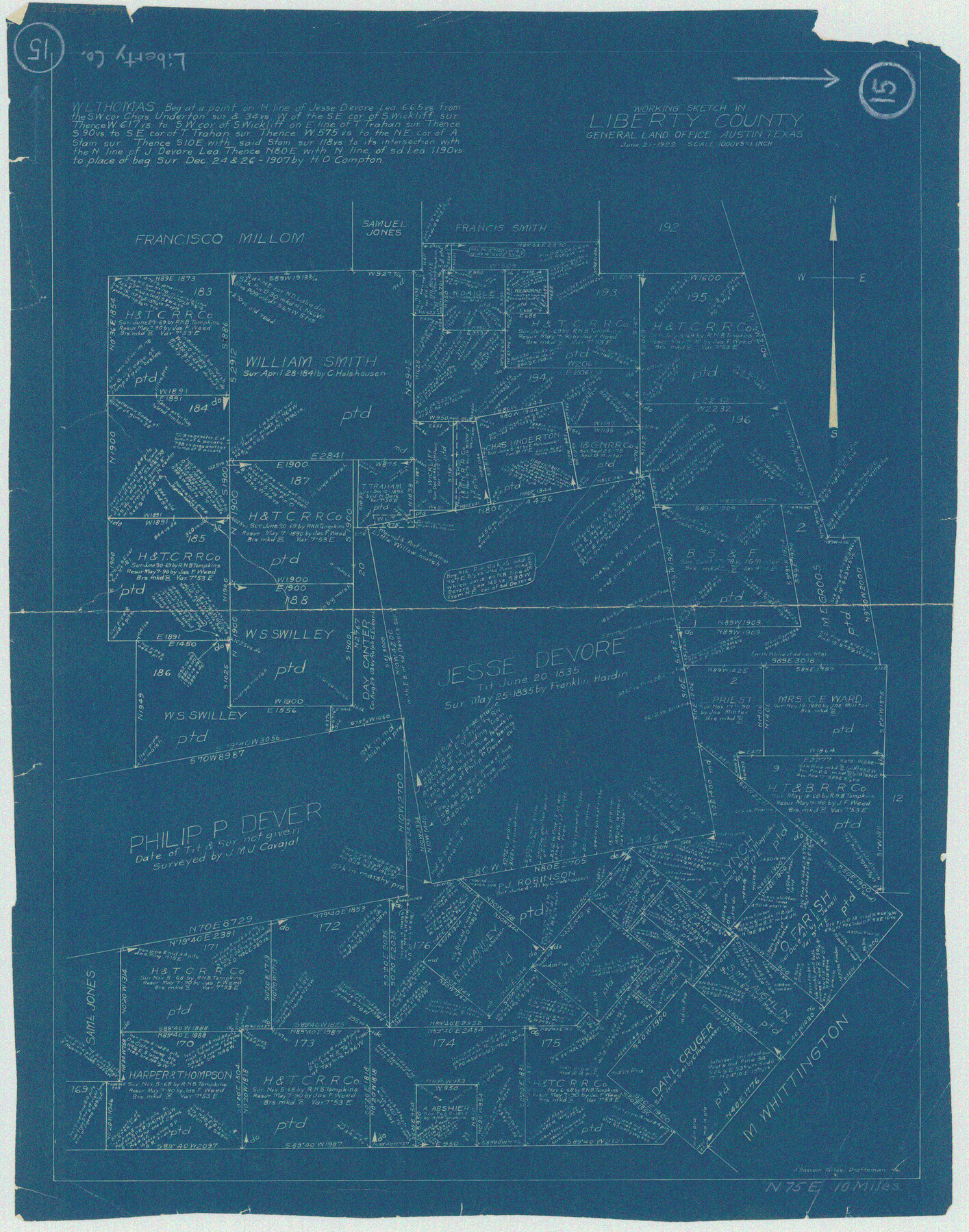
Liberty County Working Sketch 15
-
Map/Doc
70474
-
Collection
General Map Collection
-
Object Dates
6/21/1922 (Creation Date)
-
People and Organizations
J. Bascom Giles (Draftsman)
-
Counties
Liberty
-
Subjects
Surveying Working Sketch
-
Height x Width
19.0 x 15.0 inches
48.3 x 38.1 cm
-
Scale
1" = 1000 varas
Part of: General Map Collection
Shelby County Working Sketch 5

Print $20.00
- Digital $50.00
Shelby County Working Sketch 5
1941
Size 40.6 x 40.8 inches
Map/Doc 63858
Flight Mission No. DAG-17K, Frame 139, Matagorda County

Print $20.00
- Digital $50.00
Flight Mission No. DAG-17K, Frame 139, Matagorda County
1952
Size 18.5 x 22.3 inches
Map/Doc 86356
Crockett County Rolled Sketch 97

Print $20.00
- Digital $50.00
Crockett County Rolled Sketch 97
2013
Size 22.9 x 24.8 inches
Map/Doc 93664
Right of Way & Track Map, St. Louis, Brownsville & Mexico Ry. operated by St. Louis, Brownsville & Mexico Ry. Co.

Print $40.00
- Digital $50.00
Right of Way & Track Map, St. Louis, Brownsville & Mexico Ry. operated by St. Louis, Brownsville & Mexico Ry. Co.
1919
Size 25.2 x 57.1 inches
Map/Doc 64613
Edwards County Working Sketch 40

Print $20.00
- Digital $50.00
Edwards County Working Sketch 40
1949
Size 19.8 x 18.6 inches
Map/Doc 68916
Parker County Working Sketch 12

Print $20.00
- Digital $50.00
Parker County Working Sketch 12
1974
Map/Doc 71462
Hidalgo County Rolled Sketch 13

Print $20.00
- Digital $50.00
Hidalgo County Rolled Sketch 13
1960
Size 19.0 x 31.4 inches
Map/Doc 6212
Pecos County Sketch File 61

Print $40.00
- Digital $50.00
Pecos County Sketch File 61
1918
Size 16.3 x 15.3 inches
Map/Doc 33788
Pecos County Sketch File 88

Print $6.00
- Digital $50.00
Pecos County Sketch File 88
1934
Size 17.0 x 11.0 inches
Map/Doc 33984
Boundaries of Robertson's Colony and of Milam's Colony

Print $6.00
- Digital $50.00
Boundaries of Robertson's Colony and of Milam's Colony
1840
Size 9.5 x 14.8 inches
Map/Doc 1949
Flight Mission No. CRC-2R, Frame 201, Chambers County

Print $20.00
- Digital $50.00
Flight Mission No. CRC-2R, Frame 201, Chambers County
1956
Size 18.5 x 22.3 inches
Map/Doc 84779
Nueces County NRC Article 33.136 Sketch 18

Print $74.00
- Digital $50.00
Nueces County NRC Article 33.136 Sketch 18
2014
Size 22.0 x 34.0 inches
Map/Doc 94714
You may also like
Summer and Winter Health and Pleasure Resorts

Summer and Winter Health and Pleasure Resorts
1890
Size 7.7 x 5.6 inches
Map/Doc 97076
San Saba County Rolled Sketch 2

Print $20.00
- Digital $50.00
San Saba County Rolled Sketch 2
Size 38.9 x 20.7 inches
Map/Doc 7743
Hardin County Sketch File 62

Print $20.00
- Digital $50.00
Hardin County Sketch File 62
Size 19.9 x 26.2 inches
Map/Doc 11637
Gulf of Mexico

Print $20.00
- Digital $50.00
Gulf of Mexico
1900
Size 18.3 x 28.1 inches
Map/Doc 72650
Bandera County Working Sketch 42

Print $20.00
- Digital $50.00
Bandera County Working Sketch 42
1978
Size 26.9 x 29.8 inches
Map/Doc 67638
Flight Mission No. DQO-1K, Frame 154, Galveston County

Print $20.00
- Digital $50.00
Flight Mission No. DQO-1K, Frame 154, Galveston County
1952
Size 18.8 x 22.5 inches
Map/Doc 85007
Hansford County Sketch File 12

Print $6.00
- Digital $50.00
Hansford County Sketch File 12
1934
Size 11.2 x 8.9 inches
Map/Doc 24975
Ward County Boundary File 2

Print $4.00
- Digital $50.00
Ward County Boundary File 2
Size 11.1 x 8.9 inches
Map/Doc 59673
Map of Jasper County

Print $40.00
- Digital $50.00
Map of Jasper County
1918
Size 50.0 x 39.8 inches
Map/Doc 78408
Uvalde County Working Sketch 43

Print $20.00
- Digital $50.00
Uvalde County Working Sketch 43
1978
Size 29.3 x 27.7 inches
Map/Doc 72113
Bee County Sketch File 24

Print $8.00
- Digital $50.00
Bee County Sketch File 24
1879
Size 10.2 x 8.3 inches
Map/Doc 14322
Gonzales County Working Sketch 14

Print $20.00
- Digital $50.00
Gonzales County Working Sketch 14
1981
Size 18.3 x 20.9 inches
Map/Doc 63230