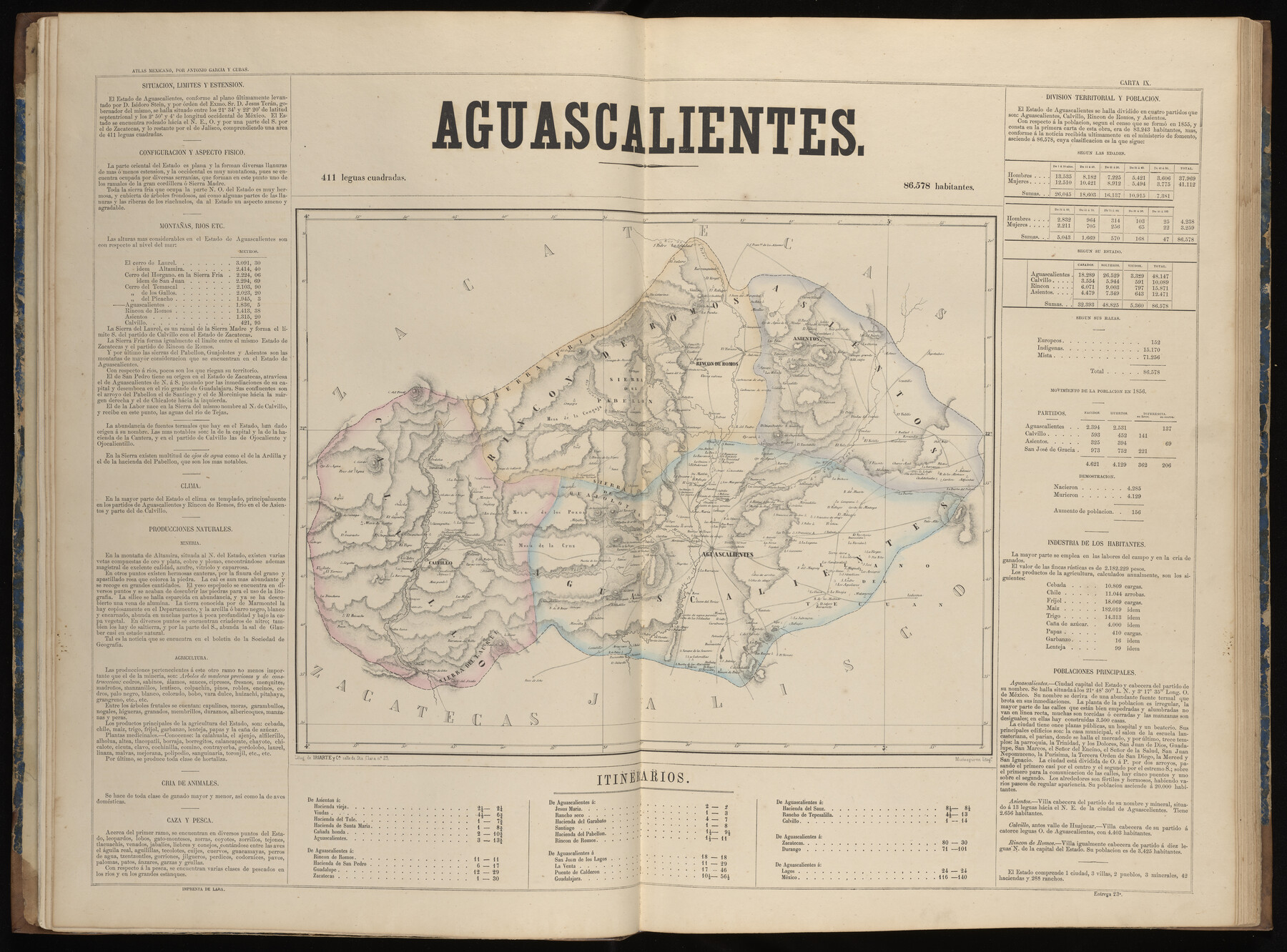
Aguascalientes
-
Map/Doc
96984
-
Collection
General Map Collection
-
Object Dates
1858 (Publication Date)
-
People and Organizations
Antonio García y Cubas (Cartographer)
-
Subjects
Atlas Mexico
-
Height x Width
23.1 x 31.2 inches
58.7 x 79.3 cm
-
Medium
paper, etching/engraving/lithograph
-
Comments
Map 3 of 32 from "Atlas Geografico, Estadistico e Historico de la Republica Mexicana" (95689)
Related maps
Atlas Geográfico, Estadístico é Histórico de la República Mexicana

Atlas Geográfico, Estadístico é Histórico de la República Mexicana
Map/Doc 95689
Part of: General Map Collection
Trinity River, Emhouse Sheet/Chambers Creek

Print $6.00
- Digital $50.00
Trinity River, Emhouse Sheet/Chambers Creek
1931
Size 35.3 x 34.8 inches
Map/Doc 65232
Maps of Block 97, Borden & Scurry Counties

Print $40.00
- Digital $50.00
Maps of Block 97, Borden & Scurry Counties
Size 58.2 x 42.2 inches
Map/Doc 65691
Flight Mission No. BQR-13K, Frame 161, Brazoria County

Print $20.00
- Digital $50.00
Flight Mission No. BQR-13K, Frame 161, Brazoria County
1952
Size 18.7 x 22.3 inches
Map/Doc 84086
In the Supreme Court of the United States, The State of Oklahoma, Complainant vs. The State of Texas, Defendant, The United States of America, Intervener, Red River Valley, Texas and Oklahoma Between the 98th and 100th Meridians in Five Sheets, 1921

Print $40.00
- Digital $50.00
In the Supreme Court of the United States, The State of Oklahoma, Complainant vs. The State of Texas, Defendant, The United States of America, Intervener, Red River Valley, Texas and Oklahoma Between the 98th and 100th Meridians in Five Sheets, 1921
1921
Size 37.2 x 59.5 inches
Map/Doc 75274
Map of Kinney County

Print $20.00
- Digital $50.00
Map of Kinney County
1875
Size 25.9 x 34.2 inches
Map/Doc 3773
Reeves County Working Sketch 39

Print $40.00
- Digital $50.00
Reeves County Working Sketch 39
1971
Size 60.9 x 36.2 inches
Map/Doc 63482
Flight Mission No. CGI-3N, Frame 43, Cameron County

Print $20.00
- Digital $50.00
Flight Mission No. CGI-3N, Frame 43, Cameron County
1954
Size 18.5 x 22.1 inches
Map/Doc 84549
Trinity County Boundary File 102

Print $14.00
- Digital $50.00
Trinity County Boundary File 102
Size 9.2 x 4.6 inches
Map/Doc 59480
Map of the State of Texas Showing Original Land Districts

Print $20.00
- Digital $50.00
Map of the State of Texas Showing Original Land Districts
1891
Size 43.7 x 43.3 inches
Map/Doc 73598
Wilbarger County Aerial Photograph Index Sheet 1

Print $20.00
- Digital $50.00
Wilbarger County Aerial Photograph Index Sheet 1
1950
Size 22.4 x 18.9 inches
Map/Doc 83750
Andrews County Working Sketch 20

Print $20.00
- Digital $50.00
Andrews County Working Sketch 20
1970
Size 43.3 x 39.1 inches
Map/Doc 67066
Culberson County Rolled Sketch 43

Print $20.00
- Digital $50.00
Culberson County Rolled Sketch 43
1947
Size 20.5 x 36.7 inches
Map/Doc 5664
You may also like
Reeves County Rolled Sketch 38

Print $20.00
- Digital $50.00
Reeves County Rolled Sketch 38
2018
Size 24.4 x 38.6 inches
Map/Doc 95385
Crockett County Rolled Sketch 28

Print $20.00
- Digital $50.00
Crockett County Rolled Sketch 28
1884
Size 42.5 x 25.8 inches
Map/Doc 5587
Flight Mission No. BRA-7M, Frame 13, Jefferson County

Print $20.00
- Digital $50.00
Flight Mission No. BRA-7M, Frame 13, Jefferson County
1953
Size 18.6 x 22.4 inches
Map/Doc 85464
Jefferson County Rolled Sketch 32

Print $40.00
- Digital $50.00
Jefferson County Rolled Sketch 32
1955
Size 26.4 x 49.3 inches
Map/Doc 9295
[Right of Way & Track Map, The Texas & Pacific Ry. Co. Main Line]
![64691, [Right of Way & Track Map, The Texas & Pacific Ry. Co. Main Line], General Map Collection](https://historictexasmaps.com/wmedia_w700/maps/64691.tif.jpg)
Print $20.00
- Digital $50.00
[Right of Way & Track Map, The Texas & Pacific Ry. Co. Main Line]
Size 10.9 x 18.6 inches
Map/Doc 64691
Reeves County Working Sketch Graphic Index

Print $20.00
- Digital $50.00
Reeves County Working Sketch Graphic Index
1945
Size 47.3 x 38.1 inches
Map/Doc 76682
Gulf of Mexico

Print $20.00
- Digital $50.00
Gulf of Mexico
1905
Size 18.3 x 26.8 inches
Map/Doc 72654
Haskell County Working Sketch 10

Print $20.00
- Digital $50.00
Haskell County Working Sketch 10
1961
Size 26.8 x 20.4 inches
Map/Doc 66068
Flight Mission No. DAG-17K, Frame 127, Matagorda County

Print $20.00
- Digital $50.00
Flight Mission No. DAG-17K, Frame 127, Matagorda County
1952
Size 18.6 x 18.7 inches
Map/Doc 86347
Terry County Rolled Sketch 9

Print $20.00
- Digital $50.00
Terry County Rolled Sketch 9
Size 23.8 x 23.9 inches
Map/Doc 7983
Zapata County Rolled Sketch 12A

Print $40.00
- Digital $50.00
Zapata County Rolled Sketch 12A
1917
Size 54.0 x 40.0 inches
Map/Doc 10165
Flight Mission No. DQO-11K, Frame 24, Galveston County

Print $20.00
- Digital $50.00
Flight Mission No. DQO-11K, Frame 24, Galveston County
1952
Size 18.6 x 22.4 inches
Map/Doc 85221