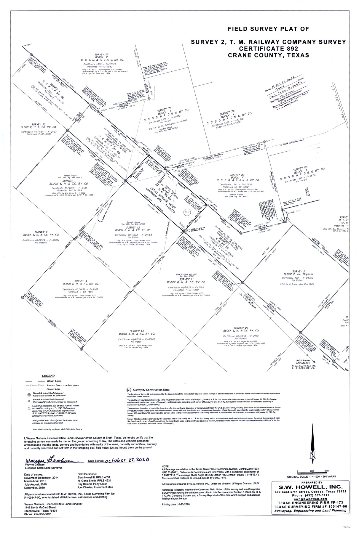
Crane County Rolled Sketch 26
Field survey plat of survey 2, T. M. Railway Company survey, certificate 892, Crane County, Texas
- 
                          Map/Doc
96432
 - 
                            Collection
General Map Collection
 - 
                            Object Dates
2020/12/2 (File Date)
2020/10/27 (Creation Date)
 - 
                            People and Organizations
Wayne Graham (Surveyor/Engineer)
Sam Howell II (Chainman/Field Personnel)
H. Gene Smith (Chainman/Field Personnel)
Ray Baland (Chainman/Field Personnel)
Joel Charles (Chainman/Field Personnel)
 - 
                            Counties
Crane
 - 
                            Subjects
Surveying Rolled Sketch
 - 
                            Height x Width
36.5 x 24.5 inches
92.7 x 62.2 cm
 - 
                            Medium
mylar, print
 - 
                            Scale
1" = 360 varas
 - 
                            Comments
See corrected field notes and surveyor's report in SCH 94275.
 
Part of: General Map Collection
            Dallam County Rolled Sketch 8


                                            Print $20.00                    
                                             -                         Digital $50.00                                    
                Dallam County Rolled Sketch 8
1949
Size 37.7 x 26.3 inches
                                Map/Doc 5686
            
            Flight Mission No. BRA-7M, Frame 149, Jefferson County


                                            Print $20.00                    
                                             -                         Digital $50.00                                    
                Flight Mission No. BRA-7M, Frame 149, Jefferson County
1953
Size 18.7 x 22.5 inches
                                Map/Doc 85543
            
            Karnes County Boundary File 5


                                            Print $32.00                    
                                             -                         Digital $50.00                                    
                Karnes County Boundary File 5
Size 12.7 x 8.2 inches
                                Map/Doc 55705
            
            Crosby County Sketch File 27


                                            Print $20.00                    
                                             -                         Digital $50.00                                    
                Crosby County Sketch File 27
Size 8.8 x 23.0 inches
                                Map/Doc 11256
            
            Flight Mission No. BRA-7M, Frame 133, Jefferson County


                                            Print $20.00                    
                                             -                         Digital $50.00                                    
                Flight Mission No. BRA-7M, Frame 133, Jefferson County
1953
Size 18.6 x 22.3 inches
                                Map/Doc 85527
            
            Edwards County Rolled Sketch 7


                                            Print $20.00                    
                                             -                         Digital $50.00                                    
                Edwards County Rolled Sketch 7
1881
Size 24.4 x 23.2 inches
                                Map/Doc 5800
            
            Callahan County Sketch File 17


                                            Print $18.00                    
                                             -                         Digital $50.00                                    
                Callahan County Sketch File 17
Size 11.0 x 8.5 inches
                                Map/Doc 93444
            
            Gregg County Rolled Sketch JB1


                                            Print $20.00                    
                                             -                         Digital $50.00                                    
                Gregg County Rolled Sketch JB1
1933
Size 43.3 x 33.4 inches
                                Map/Doc 9024
            
            Bandera County Rolled Sketch 4


                                            Print $20.00                    
                                             -                         Digital $50.00                                    
                Bandera County Rolled Sketch 4
1963
Size 36.0 x 28.5 inches
                                Map/Doc 5116
            
            General Chart of the Coast No. XVI - Gulf Coast from Galveston to the Rio Grande


                                            Print $20.00                    
                                             -                         Digital $50.00                                    
                General Chart of the Coast No. XVI - Gulf Coast from Galveston to the Rio Grande
1883
Size 26.8 x 18.1 inches
                                Map/Doc 72737
            
            Bosque County Working Sketch 11


                                            Print $20.00                    
                                             -                         Digital $50.00                                    
                Bosque County Working Sketch 11
1952
Size 10.8 x 30.4 inches
                                Map/Doc 67444
            
            Flight Mission No. DQN-2K, Frame 86, Calhoun County


                                            Print $20.00                    
                                             -                         Digital $50.00                                    
                Flight Mission No. DQN-2K, Frame 86, Calhoun County
1953
Size 18.6 x 22.2 inches
                                Map/Doc 84276
            You may also like
            Chart of Yellow Fever in the United States


                                            Print $20.00                    
                                             -                         Digital $50.00                                    
                Chart of Yellow Fever in the United States
Size 16.3 x 17.2 inches
                                Map/Doc 95701
            
            Hale County Boundary File 8


                                            Print $60.00                    
                                             -                         Digital $50.00                                    
                Hale County Boundary File 8
Size 11.8 x 9.0 inches
                                Map/Doc 54080
            
            Hardin County Sketch File 34


                                            Print $6.00                    
                                             -                         Digital $50.00                                    
                Hardin County Sketch File 34
Size 12.9 x 8.5 inches
                                Map/Doc 25172
            
            Kimble County Working Sketch 28


                                            Print $20.00                    
                                             -                         Digital $50.00                                    
                Kimble County Working Sketch 28
1938
Size 29.4 x 23.2 inches
                                Map/Doc 70096
            
            Coast Chart No. 210 Aransas Pass and Corpus Christi Bay with the coast to latitude 27° 12' Texas


                                            Print $20.00                    
                                             -                         Digital $50.00                                    
                Coast Chart No. 210 Aransas Pass and Corpus Christi Bay with the coast to latitude 27° 12' Texas
1887
Size 27.1 x 18.5 inches
                                Map/Doc 72788
            
            Cooke County Rolled Sketch 6


                                            Print $20.00                    
                                             -                         Digital $50.00                                    
                Cooke County Rolled Sketch 6
1981
Size 19.7 x 25.1 inches
                                Map/Doc 5564
            
            Shackelford County


                                            Print $20.00                    
                                             -                         Digital $50.00                                    
                Shackelford County
1920
Size 44.6 x 37.1 inches
                                Map/Doc 16813
            
            Hays County Sketch File 3


                                            Print $4.00                    
                                             -                         Digital $50.00                                    
                Hays County Sketch File 3
1846
Size 7.1 x 8.2 inches
                                Map/Doc 26202
            
            General Highway Map, Bailey County, Texas


                                            Print $20.00                    
                                    
                General Highway Map, Bailey County, Texas
1961
Size 25.0 x 18.2 inches
                                Map/Doc 79359
            
            General Highway Map.  Detail of Cities and Towns in Smith County, Texas


                                            Print $20.00                    
                                    
                General Highway Map. Detail of Cities and Towns in Smith County, Texas
1961
Size 18.3 x 24.6 inches
                                Map/Doc 79655
            
            Railroad Track Map, H&TCRRCo., Falls County, Texas


                                            Print $4.00                    
                                             -                         Digital $50.00                                    
                Railroad Track Map, H&TCRRCo., Falls County, Texas
1918
Size 11.7 x 18.5 inches
                                Map/Doc 62831
            
            Map of Encinal County, Texas


                                            Print $20.00                    
                                             -                         Digital $50.00                                    
                Map of Encinal County, Texas
1879
Size 22.7 x 28.4 inches
                                Map/Doc 715