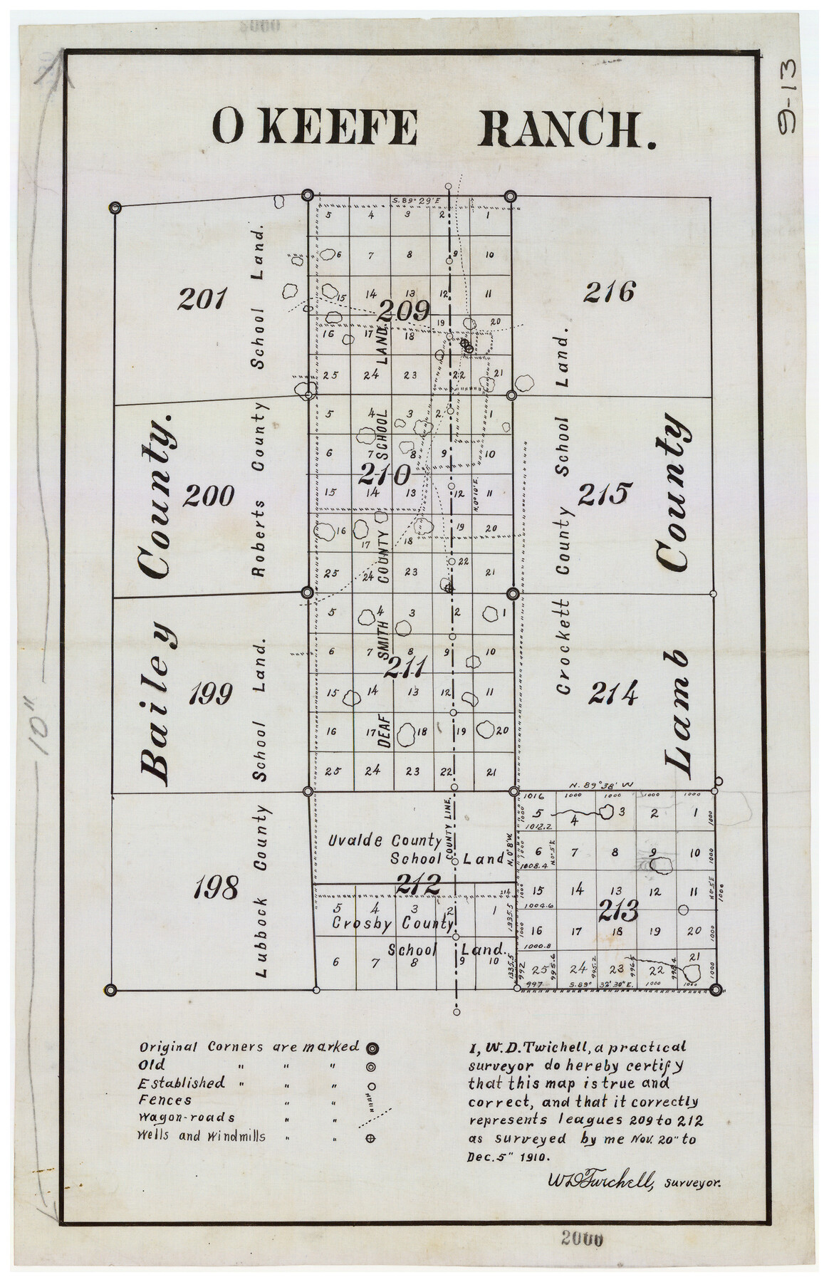
O'Keefe Ranch
9-13
-
Map/Doc
90177
-
Collection
Twichell Survey Records
-
Object Dates
12/5/1910 (Creation Date)
-
People and Organizations
W.D. Twichell (Surveyor/Engineer)
-
Counties
Bailey Lamb
-
Height x Width
10.5 x 16.5 inches
26.7 x 41.9 cm
Part of: Twichell Survey Records
[Blocks D and P]
![92490, [Blocks D and P], Twichell Survey Records](https://historictexasmaps.com/wmedia_w700/maps/92490-1.tif.jpg)
Print $20.00
- Digital $50.00
[Blocks D and P]
Size 41.8 x 29.1 inches
Map/Doc 92490
[Coleman County Sections 359, 360, and 361]
![92552, [Coleman County Sections 359, 360, and 361], Twichell Survey Records](https://historictexasmaps.com/wmedia_w700/maps/92552-1.tif.jpg)
Print $20.00
- Digital $50.00
[Coleman County Sections 359, 360, and 361]
1946
Size 17.6 x 22.6 inches
Map/Doc 92552
Map of Scurry County

Print $20.00
- Digital $50.00
Map of Scurry County
Size 17.8 x 22.7 inches
Map/Doc 92921
[Central Part of County]
![89959, [Central Part of County], Twichell Survey Records](https://historictexasmaps.com/wmedia_w700/maps/89959-1.tif.jpg)
Print $40.00
- Digital $50.00
[Central Part of County]
Size 63.1 x 34.7 inches
Map/Doc 89959
[Aaron Cherry, Augustin M. de Lejarza, & Surrounding Surveys]
![91078, [Aaron Cherry, Augustin M. de Lejarza, & Surrounding Surveys], Twichell Survey Records](https://historictexasmaps.com/wmedia_w700/maps/91078-1.tif.jpg)
Print $20.00
- Digital $50.00
[Aaron Cherry, Augustin M. de Lejarza, & Surrounding Surveys]
Size 26.3 x 16.4 inches
Map/Doc 91078
[Blocks B12 and 6T]
![91514, [Blocks B12 and 6T], Twichell Survey Records](https://historictexasmaps.com/wmedia_w700/maps/91514-1.tif.jpg)
Print $2.00
- Digital $50.00
[Blocks B12 and 6T]
Size 14.6 x 9.1 inches
Map/Doc 91514

[Portion of a sketch showing S.F. 7265]
![90386, [Portion of a sketch showing S.F. 7265], Twichell Survey Records](https://historictexasmaps.com/wmedia_w700/maps/90386-1.tif.jpg)
Print $2.00
- Digital $50.00
[Portion of a sketch showing S.F. 7265]
Size 13.3 x 9.1 inches
Map/Doc 90386
Map Showing East Part Pecos County, Texas with Blocks 194 and 178 Constructed and Adjusted to the Ground Distance from NE 36 Block 12 H&GN to Pecos Spring and by Original Field Note Calls from Pecos Spring to NE 75 Blk. 1 I&GN

Print $40.00
- Digital $50.00
Map Showing East Part Pecos County, Texas with Blocks 194 and 178 Constructed and Adjusted to the Ground Distance from NE 36 Block 12 H&GN to Pecos Spring and by Original Field Note Calls from Pecos Spring to NE 75 Blk. 1 I&GN
Size 45.0 x 51.4 inches
Map/Doc 89838
Cochran and Yoakum Counties, Texas

Print $20.00
- Digital $50.00
Cochran and Yoakum Counties, Texas
1945
Size 24.4 x 17.4 inches
Map/Doc 92513
[Block 28, Showing Edwards Ranch]
![91499, [Block 28, Showing Edwards Ranch], Twichell Survey Records](https://historictexasmaps.com/wmedia_w700/maps/91499-1.tif.jpg)
Print $3.00
- Digital $50.00
[Block 28, Showing Edwards Ranch]
Size 17.0 x 8.9 inches
Map/Doc 91499
[Blocks 56 and 57, Townships 1 and 2]
![91315, [Blocks 56 and 57, Townships 1 and 2], Twichell Survey Records](https://historictexasmaps.com/wmedia_w700/maps/91315-1.tif.jpg)
Print $20.00
- Digital $50.00
[Blocks 56 and 57, Townships 1 and 2]
Size 19.3 x 20.5 inches
Map/Doc 91315
You may also like
Liberty County Working Sketch 34

Print $20.00
- Digital $50.00
Liberty County Working Sketch 34
1946
Size 26.7 x 21.2 inches
Map/Doc 70493
[Sketch of Blocks D5-D8]
![93046, [Sketch of Blocks D5-D8], Twichell Survey Records](https://historictexasmaps.com/wmedia_w700/maps/93046-1.tif.jpg)
Print $20.00
- Digital $50.00
[Sketch of Blocks D5-D8]
Size 43.1 x 28.3 inches
Map/Doc 93046
Kimble County Sketch File 14

Print $26.00
- Digital $50.00
Kimble County Sketch File 14
1886
Size 14.1 x 8.6 inches
Map/Doc 28939
Right of Way and Track Map - Houston & Texas Central R.R. operated by the T. and N. O. R.R. Co. - Fort Worth Branch

Print $40.00
- Digital $50.00
Right of Way and Track Map - Houston & Texas Central R.R. operated by the T. and N. O. R.R. Co. - Fort Worth Branch
1918
Size 25.3 x 57.3 inches
Map/Doc 82860
Current Miscellaneous File 79

Print $6.00
- Digital $50.00
Current Miscellaneous File 79
Size 10.8 x 8.4 inches
Map/Doc 74210
Menard County Rolled Sketch 11

Print $20.00
- Digital $50.00
Menard County Rolled Sketch 11
1962
Size 24.8 x 20.1 inches
Map/Doc 6757
Travis County Boundary File 1

Print $8.00
- Digital $50.00
Travis County Boundary File 1
Size 9.0 x 14.6 inches
Map/Doc 59403
Newton County Rolled Sketch 6

Print $20.00
- Digital $50.00
Newton County Rolled Sketch 6
Size 24.9 x 45.7 inches
Map/Doc 6842
Kleberg County Rolled Sketch 10-12

Print $20.00
- Digital $50.00
Kleberg County Rolled Sketch 10-12
1951
Size 38.8 x 34.9 inches
Map/Doc 9371
General Highway Map, Lampasas County, Texas

Print $20.00
General Highway Map, Lampasas County, Texas
1961
Size 18.2 x 24.7 inches
Map/Doc 79563
[Map showing T&P Lands in El Paso County]
![88935, [Map showing T&P Lands in El Paso County], Library of Congress](https://historictexasmaps.com/wmedia_w700/maps/88935.tif.jpg)
Print $20.00
[Map showing T&P Lands in El Paso County]
Size 22.2 x 17.4 inches
Map/Doc 88935
McMullen County Rolled Sketch 11

Print $20.00
- Digital $50.00
McMullen County Rolled Sketch 11
Size 32.2 x 22.3 inches
Map/Doc 6728