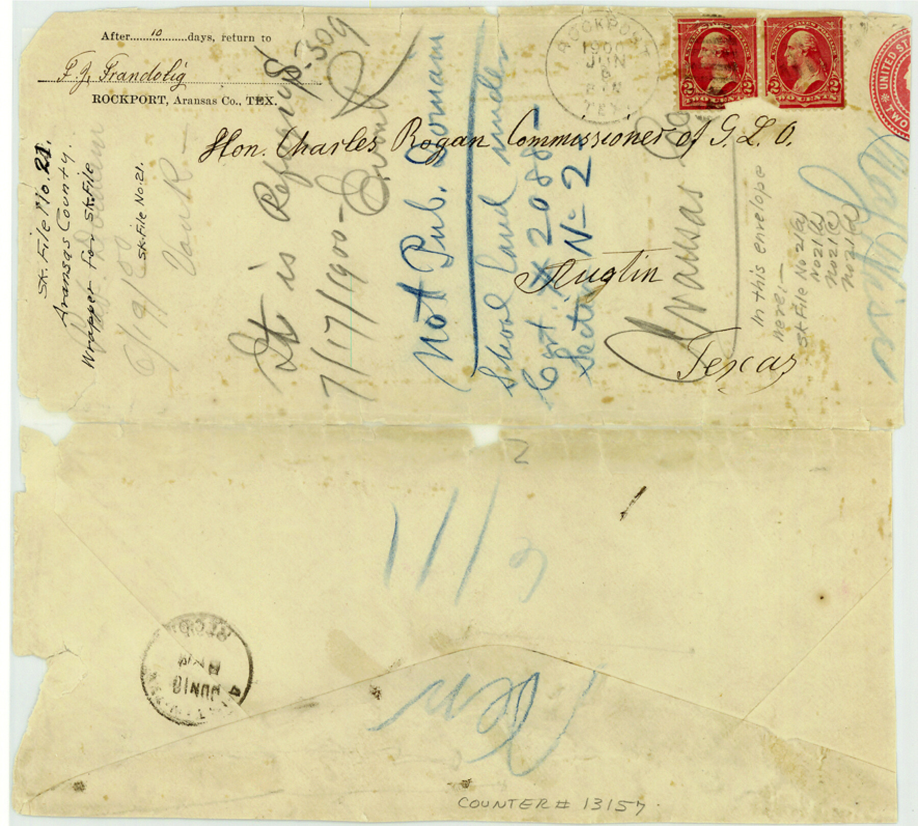
Aransas County Sketch File 21
[Wrapper for sketch file]
-
Map/Doc
13157
-
Collection
General Map Collection
-
Counties
Aransas
-
Subjects
Surveying Sketch File
-
Height x Width
8.0 x 8.9 inches
20.3 x 22.6 cm
-
Medium
paper, manuscript
Part of: General Map Collection
Brewster County Working Sketch 89

Print $20.00
- Digital $50.00
Brewster County Working Sketch 89
1974
Size 20.5 x 44.1 inches
Map/Doc 67689

Flight Mission No. CRC-4R, Frame 98, Chambers County

Print $20.00
- Digital $50.00
Flight Mission No. CRC-4R, Frame 98, Chambers County
1956
Size 18.6 x 22.3 inches
Map/Doc 84895
Calhoun County Sketch File 18

Print $61.00
- Digital $50.00
Calhoun County Sketch File 18
1990
Size 11.2 x 8.7 inches
Map/Doc 35986

Leon County Rolled Sketch 17

Print $20.00
- Digital $50.00
Leon County Rolled Sketch 17
1981
Size 25.2 x 33.4 inches
Map/Doc 6602
Reeves County Working Sketch 3

Print $20.00
- Digital $50.00
Reeves County Working Sketch 3
1908
Size 18.7 x 23.1 inches
Map/Doc 63445
Outer Continental Shelf Leasing Maps (Louisiana Offshore Operations)

Print $20.00
- Digital $50.00
Outer Continental Shelf Leasing Maps (Louisiana Offshore Operations)
1954
Size 21.2 x 16.3 inches
Map/Doc 76103
Comanche County Sketch File 27

Print $22.00
- Digital $50.00
Comanche County Sketch File 27
1912
Size 9.4 x 7.1 inches
Map/Doc 19116
Zavalla [sic] County
![16939, Zavalla [sic] County, General Map Collection](https://historictexasmaps.com/wmedia_w700/maps/16939.tif.jpg)
Print $20.00
- Digital $50.00
Zavalla [sic] County
1893
Size 44.5 x 46.3 inches
Map/Doc 16939
Crockett County Rolled Sketch 45

Print $40.00
- Digital $50.00
Crockett County Rolled Sketch 45
Size 54.8 x 16.5 inches
Map/Doc 8710
Presidio County Sketch File R1

Print $12.00
- Digital $50.00
Presidio County Sketch File R1
1927
Size 11.3 x 8.7 inches
Map/Doc 34599
You may also like
Jefferson County Sketch File 2

Print $50.00
- Digital $50.00
Jefferson County Sketch File 2
Size 11.2 x 8.8 inches
Map/Doc 28090
The Mexican Department of Bexar. May 6, 1833

Print $20.00
The Mexican Department of Bexar. May 6, 1833
2020
Size 16.0 x 21.6 inches
Map/Doc 95969
Flight Mission No. DQN-7K, Frame 11, Calhoun County

Print $20.00
- Digital $50.00
Flight Mission No. DQN-7K, Frame 11, Calhoun County
1953
Size 18.6 x 22.3 inches
Map/Doc 84462
Moxley-McWhorter Irrigated Farm

Print $20.00
- Digital $50.00
Moxley-McWhorter Irrigated Farm
1946
Size 27.5 x 15.8 inches
Map/Doc 92338
Gulf Coast of the United States, Key West to Rio Grande

Print $40.00
Gulf Coast of the United States, Key West to Rio Grande
1863
Size 30.2 x 53.5 inches
Map/Doc 79335
The Republic County of Bowie. January 16, 1843

Print $20.00
The Republic County of Bowie. January 16, 1843
2020
Size 19.5 x 21.7 inches
Map/Doc 96106
[Block B9 in Southwest Corner of Crosby County]
![90496, [Block B9 in Southwest Corner of Crosby County], Twichell Survey Records](https://historictexasmaps.com/wmedia_w700/maps/90496-1.tif.jpg)
Print $20.00
- Digital $50.00
[Block B9 in Southwest Corner of Crosby County]
Size 26.1 x 9.9 inches
Map/Doc 90496
Perspective Map of the City of Laredo, Texas, the Gateway to and from Mexico

Print $20.00
Perspective Map of the City of Laredo, Texas, the Gateway to and from Mexico
1892
Size 24.0 x 36.7 inches
Map/Doc 93478
Bandera County Sketch File 33

Print $40.00
- Digital $50.00
Bandera County Sketch File 33
1975
Size 14.4 x 17.5 inches
Map/Doc 14028
Jones County Sketch File 13a

Print $4.00
- Digital $50.00
Jones County Sketch File 13a
Size 8.3 x 15.0 inches
Map/Doc 28499
Real County Working Sketch 62

Print $20.00
- Digital $50.00
Real County Working Sketch 62
1966
Size 26.4 x 23.2 inches
Map/Doc 71954
Flight Mission No. DIX-6P, Frame 132, Aransas County

Print $20.00
- Digital $50.00
Flight Mission No. DIX-6P, Frame 132, Aransas County
1956
Size 19.3 x 23.2 inches
Map/Doc 83838