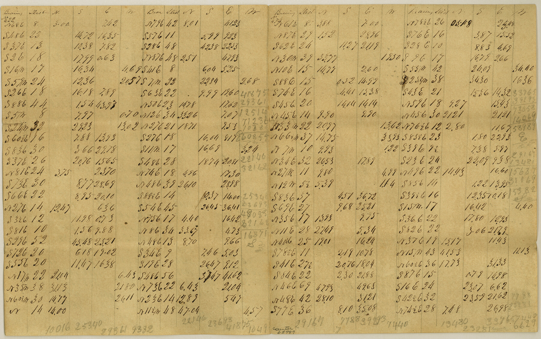
Meanders of Sulphur Fork of Red River, Red River County, Texas
K-3-7
-
Map/Doc
65787
-
Collection
General Map Collection
-
Object Dates
1841 (Creation Date)
-
Counties
Red River
-
Subjects
River Surveys
-
Height x Width
10.0 x 15.9 inches
25.4 x 40.4 cm
Part of: General Map Collection
Runnels County Working Sketch 17

Print $20.00
- Digital $50.00
Runnels County Working Sketch 17
1950
Size 27.1 x 21.5 inches
Map/Doc 63613
San Saba County Sketch File 10

Print $20.00
- Digital $50.00
San Saba County Sketch File 10
1883
Size 20.4 x 16.5 inches
Map/Doc 12290
[Surveys in Vehlein's Colony along Long King's Creek]
![83, [Surveys in Vehlein's Colony along Long King's Creek], General Map Collection](https://historictexasmaps.com/wmedia_w700/maps/83.tif.jpg)
Print $20.00
- Digital $50.00
[Surveys in Vehlein's Colony along Long King's Creek]
Size 13.3 x 19.0 inches
Map/Doc 83
Austin County Sketch File 5

Print $40.00
- Digital $50.00
Austin County Sketch File 5
1885
Size 47.7 x 24.6 inches
Map/Doc 10319
Val Verde County Working Sketch 55

Print $20.00
- Digital $50.00
Val Verde County Working Sketch 55
1957
Size 20.1 x 28.6 inches
Map/Doc 72190
Flight Mission No. CRK-7P, Frame 133, Refugio County

Print $20.00
- Digital $50.00
Flight Mission No. CRK-7P, Frame 133, Refugio County
1956
Size 18.3 x 22.1 inches
Map/Doc 86956
Angelina County Sketch File 2

Print $2.00
- Digital $50.00
Angelina County Sketch File 2
Size 8.6 x 6.0 inches
Map/Doc 12921

Jeff Davis County Rolled Sketch 11

Print $20.00
- Digital $50.00
Jeff Davis County Rolled Sketch 11
1914
Size 17.9 x 14.4 inches
Map/Doc 6364
Callahan County Sketch File 15

Print $16.00
- Digital $50.00
Callahan County Sketch File 15
1944
Size 11.2 x 8.8 inches
Map/Doc 35890
Nolan County Sketch File 2

Print $40.00
- Digital $50.00
Nolan County Sketch File 2
Size 49.5 x 41.6 inches
Map/Doc 10556
Edwards County Sketch File 34

Print $20.00
- Digital $50.00
Edwards County Sketch File 34
Size 16.8 x 19.0 inches
Map/Doc 11434
You may also like
Tanglewood, Station Map-Tracks & Structures-Lands, San Antonio & Aransas Pass Railway Co., Station 4804+179 to Station 4856+179

Print $4.00
- Digital $50.00
Tanglewood, Station Map-Tracks & Structures-Lands, San Antonio & Aransas Pass Railway Co., Station 4804+179 to Station 4856+179
1919
Size 11.7 x 18.6 inches
Map/Doc 62569
Fort Parker State Park

Print $20.00
- Digital $50.00
Fort Parker State Park
1950
Size 26.0 x 37.8 inches
Map/Doc 73569
Eastland County Working Sketch 64

Print $40.00
- Digital $50.00
Eastland County Working Sketch 64
1983
Size 43.3 x 68.4 inches
Map/Doc 88891
Roberts County Working Sketch 42

Print $20.00
- Digital $50.00
Roberts County Working Sketch 42
1978
Size 26.7 x 22.7 inches
Map/Doc 63568
Aransas County Rolled Sketch 28

Print $20.00
- Digital $50.00
Aransas County Rolled Sketch 28
1987
Size 24.5 x 30.9 inches
Map/Doc 77496
General Highway Map, Wichita County, Texas

Print $20.00
General Highway Map, Wichita County, Texas
1961
Size 18.2 x 24.6 inches
Map/Doc 79709
General Highway Map, Bosque County, Texas

Print $20.00
General Highway Map, Bosque County, Texas
1940
Size 25.3 x 18.5 inches
Map/Doc 79022
[Survey 9, Block 9 Potter and Randall]
![91720, [Survey 9, Block 9 Potter and Randall], Twichell Survey Records](https://historictexasmaps.com/wmedia_w700/maps/91720-1.tif.jpg)
Print $20.00
- Digital $50.00
[Survey 9, Block 9 Potter and Randall]
Size 22.3 x 15.9 inches
Map/Doc 91720
Sabine River, Merrill Lake Sheet

Print $20.00
- Digital $50.00
Sabine River, Merrill Lake Sheet
1933
Size 26.4 x 43.6 inches
Map/Doc 65137

St. L. S.-W. Ry. of Texas, Map of Lufkin Branch in Smith County, Texas

Print $20.00
- Digital $50.00
St. L. S.-W. Ry. of Texas, Map of Lufkin Branch in Smith County, Texas
1912
Size 23.1 x 37.2 inches
Map/Doc 64694
Sabine Bank to East Bay including Heald Bank

Print $20.00
- Digital $50.00
Sabine Bank to East Bay including Heald Bank
1976
Size 45.0 x 34.5 inches
Map/Doc 69851