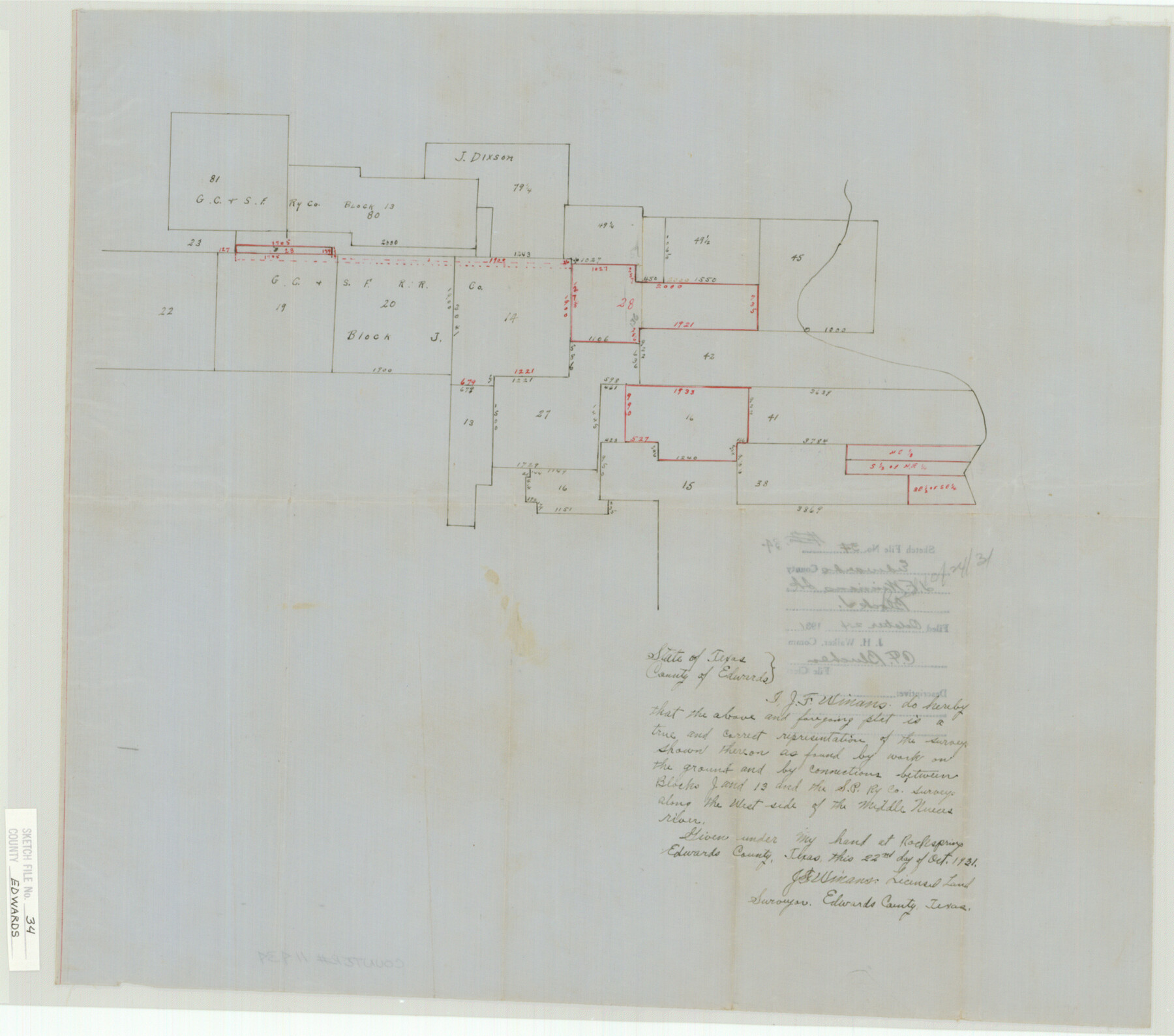
Edwards County Sketch File 34
Block J
-
Map/Doc
11434
-
Collection
General Map Collection
-
Object Dates
1931/10/24 (File Date)
1931 (Survey Date)
-
People and Organizations
J.F. Winans (Surveyor/Engineer)
-
Counties
Edwards
-
Subjects
Surveying Sketch File
-
Height x Width
16.8 x 19.0 inches
42.7 x 48.3 cm
-
Medium
paper, manuscript
Part of: General Map Collection
Sabine Pass and Lake

Print $20.00
- Digital $50.00
Sabine Pass and Lake
1971
Size 47.0 x 27.5 inches
Map/Doc 69825
Crockett County Sketch File 54

Print $10.00
- Digital $50.00
Crockett County Sketch File 54
1915
Size 11.3 x 8.9 inches
Map/Doc 19824
Galveston County NRC Article 33.136 Sketch 81

Print $202.00
- Digital $50.00
Galveston County NRC Article 33.136 Sketch 81
2015
Size 34.0 x 22.0 inches
Map/Doc 94976
Upton County Sketch File 16

Print $4.00
- Digital $50.00
Upton County Sketch File 16
1926
Size 11.4 x 8.8 inches
Map/Doc 38873
Palo Pinto County Rolled Sketch 15

Print $20.00
- Digital $50.00
Palo Pinto County Rolled Sketch 15
Size 19.2 x 24.5 inches
Map/Doc 88734
Webb County Sketch File 1a

Print $20.00
- Digital $50.00
Webb County Sketch File 1a
1871
Size 23.3 x 18.0 inches
Map/Doc 12623
Webb County Sketch File 72

Print $24.00
- Digital $50.00
Webb County Sketch File 72
2011
Size 11.0 x 8.5 inches
Map/Doc 90054
Parker County Sketch File 44

Print $6.00
- Digital $50.00
Parker County Sketch File 44
1874
Size 11.0 x 13.5 inches
Map/Doc 33608
Culberson County Working Sketch 86

Print $40.00
- Digital $50.00
Culberson County Working Sketch 86
1981
Size 37.3 x 53.3 inches
Map/Doc 68540
[Surveys in the Travis District along the Colorado River]
![115, [Surveys in the Travis District along the Colorado River], General Map Collection](https://historictexasmaps.com/wmedia_w700/maps/115.tif.jpg)
Print $2.00
- Digital $50.00
[Surveys in the Travis District along the Colorado River]
1840
Size 8.0 x 10.2 inches
Map/Doc 115
Sketch of a portion of the Texas Coast showing the relative positions of different harbours with the interior Military Posts, and the roads communicating with them, also two new routes from Black Point and Lamar to San Antonio

Print $20.00
- Digital $50.00
Sketch of a portion of the Texas Coast showing the relative positions of different harbours with the interior Military Posts, and the roads communicating with them, also two new routes from Black Point and Lamar to San Antonio
1855
Size 27.3 x 18.3 inches
Map/Doc 72710
Menard County Sketch File 1

Print $4.00
- Digital $50.00
Menard County Sketch File 1
1859
Size 9.8 x 8.5 inches
Map/Doc 31484
You may also like
Working Sketch Bastrop County

Print $20.00
- Digital $50.00
Working Sketch Bastrop County
1923
Size 17.0 x 13.1 inches
Map/Doc 90145
Flight Mission No. DAG-24K, Frame 45, Matagorda County

Print $20.00
- Digital $50.00
Flight Mission No. DAG-24K, Frame 45, Matagorda County
1953
Size 18.6 x 22.2 inches
Map/Doc 86532
Crane County Working Sketch 15

Print $20.00
- Digital $50.00
Crane County Working Sketch 15
1946
Size 33.6 x 38.0 inches
Map/Doc 68292
PSL Field Notes for Block C24 in Loving and Winkler Counties, and Blocks C22 and C23 in Winkler County

PSL Field Notes for Block C24 in Loving and Winkler Counties, and Blocks C22 and C23 in Winkler County
Map/Doc 81677
Flight Mission No. DCL-6C, Frame 23, Kenedy County

Print $20.00
- Digital $50.00
Flight Mission No. DCL-6C, Frame 23, Kenedy County
1943
Size 18.7 x 22.3 inches
Map/Doc 85880

Orange County Sketch File 17

Print $50.00
- Digital $50.00
Orange County Sketch File 17
1922
Size 11.1 x 8.6 inches
Map/Doc 33337
Kenedy County Rolled Sketch 18

Print $20.00
- Digital $50.00
Kenedy County Rolled Sketch 18
1995
Size 29.5 x 39.2 inches
Map/Doc 6472
Webb County Working Sketch 5

Print $20.00
- Digital $50.00
Webb County Working Sketch 5
1909
Size 20.1 x 15.4 inches
Map/Doc 72370
Wilson County Boundary File 4

Print $26.00
- Digital $50.00
Wilson County Boundary File 4
Size 8.9 x 7.8 inches
Map/Doc 60096
El Paso County Boundary File 7

Print $14.00
- Digital $50.00
El Paso County Boundary File 7
Size 14.0 x 8.8 inches
Map/Doc 53087
United States - Gulf Coast - Galveston to Rio Grande

Print $20.00
- Digital $50.00
United States - Gulf Coast - Galveston to Rio Grande
1941
Size 26.6 x 18.5 inches
Map/Doc 72752