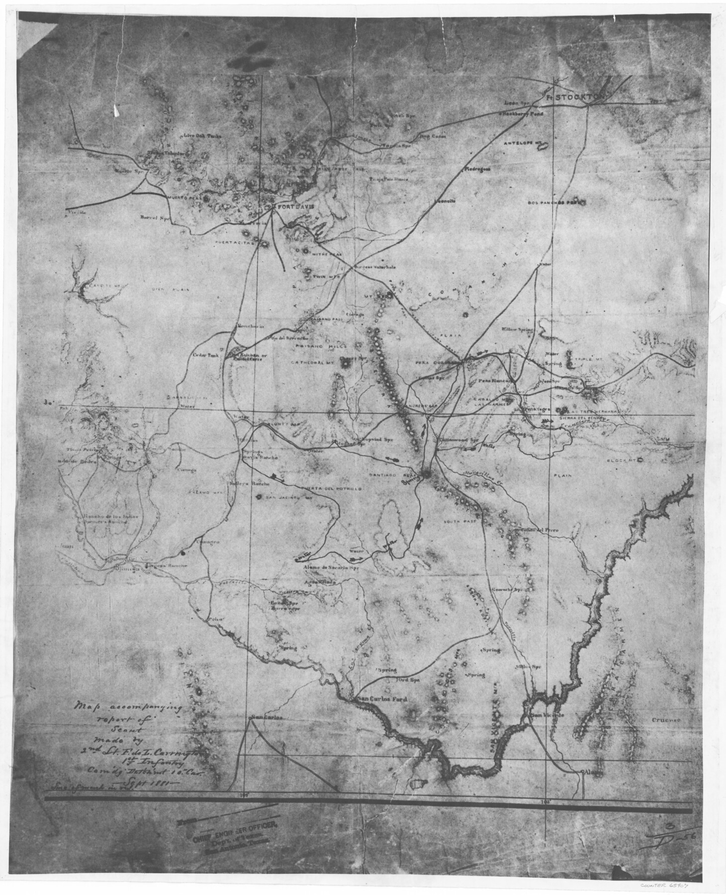
Map accompanying report of scout made by 2nd Lt. F. de I. Carrington. 1st Infantry
K-7-17
-
Map/Doc
65407
-
Collection
General Map Collection
-
Object Dates
1881 (Creation Date)
-
People and Organizations
F. de L. Carrington (Draftsman)
-
Counties
Jeff Davis Pecos Presidio Brewster
-
Subjects
Military
-
Height x Width
22.2 x 18.0 inches
56.4 x 45.7 cm
-
Medium
photostat
-
Comments
Commanding Detachment of the 19th Cavalry
-
Features
Andrew's Gap
Rancheria
Cedar Tank
Painted Caves
San Esteban
San Esteban or Painted Caves
Blunt's Gap
Paisano Hills
Cathedral Mountain
Cherry Springs
Ojo del Arriento
Colinas Springs
Pena Colorado Mountain
Willow Spring
Triple Mountain
Mason's Spring
Pean Negra Mountain
Pena Negro Creek
Las Narices Mountain
Caballo Mountain
Muerto Peak
Leoncito
Piedregoso
Leon Creek
Leon Springs
Hackberry Pond
Fort Stockton
Antelope Mountain
Dos Panchos Peak
Live Oak Tanks
San Francisco Creek
Tinaja Voluntario
Muerto Springs
Viejita
Barrel Springs
Capote Mountain
Mitre Peak
Fort Davis
Puertacitas
Paisano Pass
Canon del Perro
Poho
Potrecilo Creek
Ternera Creek
Alamo de Sacaria Springs
Agua Helada Springs
Burro Spring
Ganen's Spring
Las Lenguas Creek
Muravillas Creek
Canagra
South Pass
Terra Rosilla
Guarache Spring
Tornillo Creek
Cruces
Alamo
San Vicente
Ord Spring
San Carlos Ford
Tinaja Prieto Mountains
Sierra del Venado Mountain
Las Tres Hermana Mountain
Block Mountain
Cottonwood Springs
Santiago Peak
Chopwind Springs
Hughes Spring
Lunt's Gap
Penitas
San Carlos
[ ]ado de Bedra
Alamo Mountains
Cienega
Cibare Creek
Juan
Vallehas Creek
Sjimiga
Del Norte
Part of: General Map Collection
Township No. 4 South Range No. 15 West of the Indian Meridian

Print $4.00
- Digital $50.00
Township No. 4 South Range No. 15 West of the Indian Meridian
1875
Size 17.9 x 22.4 inches
Map/Doc 75151
Cooke County Sketch File 30

Print $4.00
- Digital $50.00
Cooke County Sketch File 30
Size 8.8 x 5.5 inches
Map/Doc 19291
A Map of Sterling County

Print $20.00
- Digital $50.00
A Map of Sterling County
1919
Size 33.3 x 21.6 inches
Map/Doc 4054
Polk County Sketch File 27

Print $8.00
- Digital $50.00
Polk County Sketch File 27
1891
Size 14.1 x 8.7 inches
Map/Doc 34194
Polk County Working Sketch 30

Print $20.00
- Digital $50.00
Polk County Working Sketch 30
1960
Size 18.2 x 24.4 inches
Map/Doc 71646
Fractional Township No. 1N and Township No. 2N R. No. 2E, Deaf Smith and Parmer Counties comprising Capitol Leagues 439 and 452 and parts of Capitol Leagues 431, 432, 433, 438, 440, 451, 453, 458, 459, and 460

Print $20.00
- Digital $50.00
Fractional Township No. 1N and Township No. 2N R. No. 2E, Deaf Smith and Parmer Counties comprising Capitol Leagues 439 and 452 and parts of Capitol Leagues 431, 432, 433, 438, 440, 451, 453, 458, 459, and 460
1906
Size 27.1 x 22.4 inches
Map/Doc 93966
Reeves County

Print $40.00
- Digital $50.00
Reeves County
1915
Size 48.4 x 38.7 inches
Map/Doc 66999
Potter County Rolled Sketch 9

Print $20.00
- Digital $50.00
Potter County Rolled Sketch 9
1931
Size 36.7 x 25.3 inches
Map/Doc 7322
Potter County Sketch File 22

Print $30.00
- Digital $50.00
Potter County Sketch File 22
1962
Size 14.2 x 8.6 inches
Map/Doc 34415
Collin County Boundary File 3

Print $12.00
- Digital $50.00
Collin County Boundary File 3
Size 10.9 x 7.0 inches
Map/Doc 51685
Flight Mission No. BRA-7M, Frame 190, Jefferson County

Print $20.00
- Digital $50.00
Flight Mission No. BRA-7M, Frame 190, Jefferson County
1953
Size 18.7 x 22.3 inches
Map/Doc 85558
Eastland County Working Sketch 10

Print $20.00
- Digital $50.00
Eastland County Working Sketch 10
1919
Size 20.2 x 16.3 inches
Map/Doc 68791
You may also like
Shelby County Working Sketch 11

Print $20.00
- Digital $50.00
Shelby County Working Sketch 11
1945
Size 32.2 x 43.2 inches
Map/Doc 63864
Loving County, Texas

Print $20.00
- Digital $50.00
Loving County, Texas
1889
Size 18.8 x 23.8 inches
Map/Doc 638
Burnet County Rolled Sketch 4

Print $20.00
- Digital $50.00
Burnet County Rolled Sketch 4
1949
Size 31.9 x 17.5 inches
Map/Doc 5356
Eastland County Rolled Sketch 14

Print $20.00
- Digital $50.00
Eastland County Rolled Sketch 14
Size 18.5 x 18.3 inches
Map/Doc 5775
Flight Mission No. CRC-2R, Frame 200, Chambers County

Print $20.00
- Digital $50.00
Flight Mission No. CRC-2R, Frame 200, Chambers County
1956
Size 18.8 x 22.4 inches
Map/Doc 84778
Dickens County Working Sketch 4

Print $20.00
- Digital $50.00
Dickens County Working Sketch 4
1914
Size 27.9 x 18.8 inches
Map/Doc 68651
Concho County Rolled Sketch 1

Print $20.00
- Digital $50.00
Concho County Rolled Sketch 1
1945
Size 19.5 x 25.0 inches
Map/Doc 5543
Cass County Rolled Sketch 1

Print $20.00
- Digital $50.00
Cass County Rolled Sketch 1
1945
Size 22.1 x 23.7 inches
Map/Doc 5408
Flight Mission No. CRC-2R, Frame 111, Chambers County

Print $20.00
- Digital $50.00
Flight Mission No. CRC-2R, Frame 111, Chambers County
1956
Size 18.4 x 22.3 inches
Map/Doc 84738
![91538, [Block 3T], Twichell Survey Records](https://historictexasmaps.com/wmedia_w700/maps/91538-1.tif.jpg)
Red River County Rolled Sketch 3

Print $20.00
- Digital $50.00
Red River County Rolled Sketch 3
Size 36.9 x 31.0 inches
Map/Doc 9840
Carson County Working Sketch 5

Print $20.00
- Digital $50.00
Carson County Working Sketch 5
1979
Size 42.2 x 14.5 inches
Map/Doc 67876