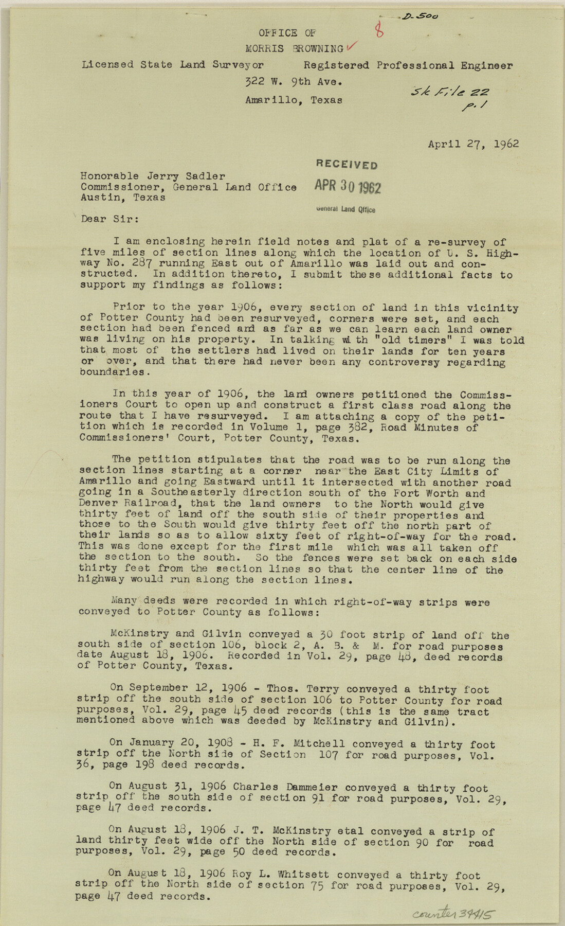
Potter County Sketch File 22
[Report and sketch of a survey of the dividing line between sections 52, 53, 58, 59, 74, 75, 90, 91, 106 and 107, Block 2, A. B. & M.]
-
Map/Doc
34415
-
Collection
General Map Collection
-
Object Dates
4/27/1962 (Creation Date)
4/30/1962 (File Date)
4/27/1962 (Correspondence Date)
7/1919 (Survey Date)
1930 (Survey Date)
4/30/1962 (Survey Date)
-
People and Organizations
Morris Browning (Surveyor/Engineer)
W.J. Williams (Surveyor/Engineer)
John F. Barbara (Chainman/Field Personnel)
Leslie Caldwell (Chainman/Field Personnel)
-
Counties
Potter Randall
-
Subjects
Surveying Sketch File
-
Height x Width
14.2 x 8.6 inches
36.1 x 21.8 cm
-
Medium
paper, print
-
Scale
1" = 2000'
-
Features
U.S. Highway 287
Amarillo
FW&D
Claude
Pullman Road
Part of: General Map Collection
El Paso County Working Sketch 44

Print $20.00
- Digital $50.00
El Paso County Working Sketch 44
1992
Size 25.6 x 25.4 inches
Map/Doc 69066
Falls County Boundary File 2

Print $6.00
- Digital $50.00
Falls County Boundary File 2
Size 9.9 x 6.6 inches
Map/Doc 53263
Fort Bend County

Print $20.00
- Digital $50.00
Fort Bend County
1865
Size 18.2 x 21.8 inches
Map/Doc 3550
Map of the Western Branch of Houston & Tex. Central R.R. for the Distance from Brenham to Austin

Print $40.00
- Digital $50.00
Map of the Western Branch of Houston & Tex. Central R.R. for the Distance from Brenham to Austin
1872
Size 32.6 x 97.3 inches
Map/Doc 64578
Marion County Working Sketch 10

Print $20.00
- Digital $50.00
Marion County Working Sketch 10
1949
Size 30.9 x 30.2 inches
Map/Doc 70785
McLennan County Sketch File 7a

Print $4.00
- Digital $50.00
McLennan County Sketch File 7a
1850
Size 10.3 x 7.4 inches
Map/Doc 31246
Flight Mission No. DCL-6C, Frame 96, Kenedy County

Print $20.00
- Digital $50.00
Flight Mission No. DCL-6C, Frame 96, Kenedy County
1943
Size 18.6 x 22.4 inches
Map/Doc 85926
Culberson County Sketch File 32

Print $22.00
- Digital $50.00
Culberson County Sketch File 32
1952
Size 11.2 x 8.7 inches
Map/Doc 20285
Austin Map and Street Guide [Verso]
![94163, Austin Map and Street Guide [Verso], General Map Collection](https://historictexasmaps.com/wmedia_w700/maps/94163.tif.jpg)
Austin Map and Street Guide [Verso]
1986
Size 35.5 x 22.8 inches
Map/Doc 94163
Nueces County Sketch File 86

Print $2.00
- Digital $50.00
Nueces County Sketch File 86
Map/Doc 81935
Greater Austin, Texas Streetmap

Greater Austin, Texas Streetmap
Size 46.1 x 36.3 inches
Map/Doc 94430
Nueces County Aerial Photograph Index Sheet 21

Print $20.00
- Digital $50.00
Nueces County Aerial Photograph Index Sheet 21
1938
Size 24.3 x 20.2 inches
Map/Doc 86842
You may also like
Brown County Working Sketch 7

Print $20.00
- Digital $50.00
Brown County Working Sketch 7
1954
Size 26.5 x 28.7 inches
Map/Doc 67772
Hutchinson County Working Sketch 23

Print $20.00
- Digital $50.00
Hutchinson County Working Sketch 23
1967
Size 34.6 x 35.3 inches
Map/Doc 66383
Maverick County Working Sketch 1

Print $20.00
- Digital $50.00
Maverick County Working Sketch 1
1906
Size 11.5 x 11.1 inches
Map/Doc 70893
Tom Green County Sketch File 73

Print $12.00
- Digital $50.00
Tom Green County Sketch File 73
1949
Size 11.2 x 8.8 inches
Map/Doc 38244
Controlled Mosaic by Jack Amman Photogrammetric Engineers, Inc - Sheet 24

Print $20.00
- Digital $50.00
Controlled Mosaic by Jack Amman Photogrammetric Engineers, Inc - Sheet 24
1954
Size 20.0 x 24.0 inches
Map/Doc 83475
Live Oak County Boundary File 60c

Print $4.00
- Digital $50.00
Live Oak County Boundary File 60c
Size 14.0 x 8.7 inches
Map/Doc 56421
Right of Way and Track Map, the Missouri, Kansas and Texas Ry. of Texas operated by the Missouri, Kansas and Texas Ry. of Texas, San Antonio Division

Print $40.00
- Digital $50.00
Right of Way and Track Map, the Missouri, Kansas and Texas Ry. of Texas operated by the Missouri, Kansas and Texas Ry. of Texas, San Antonio Division
1918
Size 25.6 x 58.7 inches
Map/Doc 64581
[Atchison, Topeka & Santa Fe from Paisano to south of Plata]
![64709, [Atchison, Topeka & Santa Fe from Paisano to south of Plata], General Map Collection](https://historictexasmaps.com/wmedia_w700/maps/64709.tif.jpg)
Print $40.00
- Digital $50.00
[Atchison, Topeka & Santa Fe from Paisano to south of Plata]
Size 32.3 x 120.8 inches
Map/Doc 64709
El Paso County Working Sketch 21

Print $20.00
- Digital $50.00
El Paso County Working Sketch 21
1960
Size 37.8 x 30.9 inches
Map/Doc 69043
Amended Plat New Hobbs Addition to New Hobbs, Lea County, New Mexico

Print $20.00
- Digital $50.00
Amended Plat New Hobbs Addition to New Hobbs, Lea County, New Mexico
Size 24.1 x 18.5 inches
Map/Doc 92418
Callahan County Sketch File 17

Print $18.00
- Digital $50.00
Callahan County Sketch File 17
Size 11.0 x 8.5 inches
Map/Doc 93444
Bee County Sketch File 31

Print $6.00
- Digital $50.00
Bee County Sketch File 31
1886
Size 12.8 x 8.2 inches
Map/Doc 14344