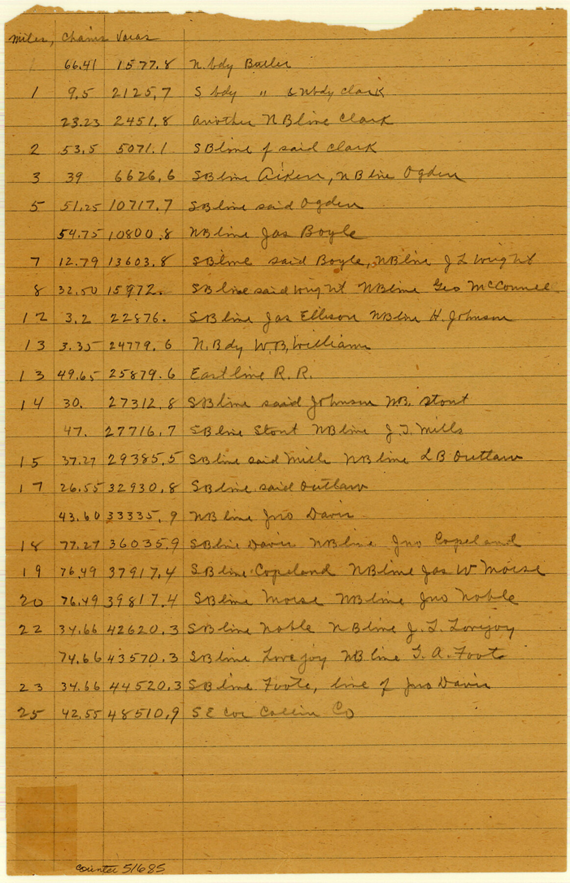
Collin County Boundary File 3
Fieldnote Description and Calcuations on the Collin County Boundary line
-
Map/Doc
51685
-
Collection
General Map Collection
-
Counties
Collin
-
Subjects
County Boundaries
-
Height x Width
10.9 x 7.0 inches
27.7 x 17.8 cm
Part of: General Map Collection
Hamilton County Sketch File 24

Print $20.00
- Digital $50.00
Hamilton County Sketch File 24
1953
Size 23.2 x 22.8 inches
Map/Doc 11619
United States - Gulf Coast - From Latitude 26° 33' to the Rio Grande Texas

Print $20.00
- Digital $50.00
United States - Gulf Coast - From Latitude 26° 33' to the Rio Grande Texas
1913
Size 18.3 x 23.6 inches
Map/Doc 72844
Parker County Sketch File 13

Print $4.00
- Digital $50.00
Parker County Sketch File 13
1860
Size 12.1 x 8.0 inches
Map/Doc 33546
Intracoastal Waterway in Texas - Corpus Christi to Point Isabel including Arroyo Colorado to Mo. Pac. R.R. Bridge Near Harlingen

Print $20.00
- Digital $50.00
Intracoastal Waterway in Texas - Corpus Christi to Point Isabel including Arroyo Colorado to Mo. Pac. R.R. Bridge Near Harlingen
1933
Size 28.1 x 41.4 inches
Map/Doc 61871
McMullen County Sketch File 37

Print $6.00
- Digital $50.00
McMullen County Sketch File 37
1937
Size 14.3 x 8.8 inches
Map/Doc 31410
El Paso County Working Sketch Graphic Index - north part

Print $20.00
- Digital $50.00
El Paso County Working Sketch Graphic Index - north part
1977
Size 33.4 x 45.0 inches
Map/Doc 76536
Starr County Sketch File 46

Print $20.00
- Digital $50.00
Starr County Sketch File 46
1949
Size 23.3 x 26.6 inches
Map/Doc 12343
Edwards County Working Sketch 2

Print $20.00
- Digital $50.00
Edwards County Working Sketch 2
Size 13.6 x 19.0 inches
Map/Doc 68878
Winkler County Rolled Sketch 15

Print $20.00
- Digital $50.00
Winkler County Rolled Sketch 15
1968
Size 25.1 x 37.8 inches
Map/Doc 10305
Bexar County Sketch File X

Print $4.00
- Digital $50.00
Bexar County Sketch File X
1878
Size 8.0 x 10.5 inches
Map/Doc 14463
Outer Continental Shelf Leasing Maps (Texas Offshore Operations)

Print $20.00
- Digital $50.00
Outer Continental Shelf Leasing Maps (Texas Offshore Operations)
Size 17.0 x 18.4 inches
Map/Doc 75847
Webb County Rolled Sketch 65

Print $20.00
- Digital $50.00
Webb County Rolled Sketch 65
1949
Size 37.1 x 24.3 inches
Map/Doc 8214
You may also like
Aransas County Boundary File 8

Print $135.00
- Digital $50.00
Aransas County Boundary File 8
Size 33.6 x 74.0 inches
Map/Doc 50043
Medina County Rolled Sketch 22

Print $20.00
- Digital $50.00
Medina County Rolled Sketch 22
2007
Size 24.5 x 18.4 inches
Map/Doc 88849
Houston County Working Sketch 15

Print $20.00
- Digital $50.00
Houston County Working Sketch 15
1960
Size 26.3 x 20.0 inches
Map/Doc 66245
Dawson County Boundary File 1

Print $48.00
- Digital $50.00
Dawson County Boundary File 1
Size 8.8 x 4.0 inches
Map/Doc 52314
Presidio County Rolled Sketch 130

Print $40.00
- Digital $50.00
Presidio County Rolled Sketch 130
1993
Size 33.6 x 49.1 inches
Map/Doc 9800
Upton County Working Sketch 54

Print $20.00
- Digital $50.00
Upton County Working Sketch 54
1983
Size 23.2 x 37.7 inches
Map/Doc 69551
Coleman County Sketch File 26

Print $40.00
- Digital $50.00
Coleman County Sketch File 26
1873
Size 12.7 x 15.5 inches
Map/Doc 18712
Hutchinson County

Print $20.00
- Digital $50.00
Hutchinson County
1922
Size 14.6 x 17.6 inches
Map/Doc 91183
Flight Mission No. DCL-7C, Frame 97, Kenedy County

Print $20.00
- Digital $50.00
Flight Mission No. DCL-7C, Frame 97, Kenedy County
1943
Size 15.3 x 15.2 inches
Map/Doc 86069
Tarrant County Sketch File 6

Print $4.00
- Digital $50.00
Tarrant County Sketch File 6
1859
Size 6.8 x 8.3 inches
Map/Doc 37682
Stonewall County Working Sketch 9

Print $20.00
- Digital $50.00
Stonewall County Working Sketch 9
1950
Size 27.9 x 34.1 inches
Map/Doc 62316
