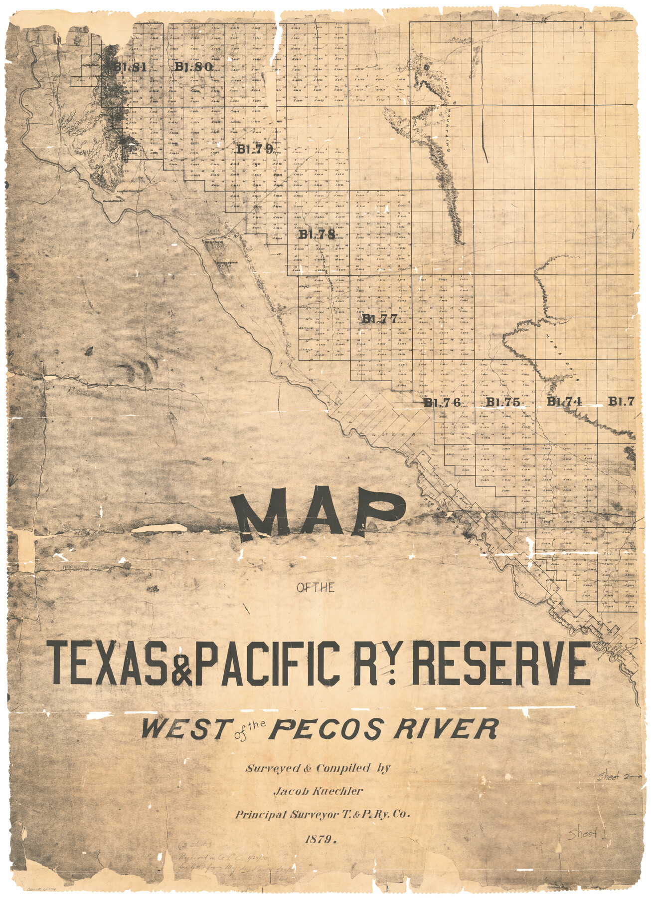
Map of the Texas & Pacific Ry. Reserve West of the Pecos River
K-7-34
-
Map/Doc
65334
-
Collection
General Map Collection
-
Object Dates
1879 (Creation Date)
1/24/1930 (File Date)
-
People and Organizations
Jacob Kuechler (Compiler)
Jacob Kuechler (Surveyor/Engineer)
-
Counties
Pecos El Paso
-
Subjects
Texas and Pacific Railroad
-
Height x Width
41.2 x 29.9 inches
104.7 x 76.0 cm
-
Comments
Sheet 1 of 3. For sheet 2 see 65333 and for sheet 3 see 65332. For a digital composite of all three sheets see 96439
Related maps
Map of the Texas & Pacific Ry. Reserve West of the Pecos River

Print $20.00
- Digital $50.00
Map of the Texas & Pacific Ry. Reserve West of the Pecos River
1879
Size 41.1 x 29.8 inches
Map/Doc 65332
Map of the Texas & Pacific Ry. Reserve West of the Pecos River

Print $20.00
- Digital $50.00
Map of the Texas & Pacific Ry. Reserve West of the Pecos River
1879
Size 40.8 x 30.2 inches
Map/Doc 65333
Map of the Texas & Pacific Ry. Reserve West of the Pecos River

Print $40.00
- Digital $50.00
Map of the Texas & Pacific Ry. Reserve West of the Pecos River
1879
Size 55.4 x 118.1 inches
Map/Doc 96439
Part of: General Map Collection
Hutchinson County Working Sketch 17

Print $20.00
- Digital $50.00
Hutchinson County Working Sketch 17
Size 45.8 x 44.2 inches
Map/Doc 66376
Kerr County Sketch File 16

Print $40.00
- Digital $50.00
Kerr County Sketch File 16
1948
Size 18.2 x 14.2 inches
Map/Doc 28888
[Gulf, Colorado & Santa Fe]
![64577, [Gulf, Colorado & Santa Fe], General Map Collection](https://historictexasmaps.com/wmedia_w700/maps/64577.tif.jpg)
Print $20.00
- Digital $50.00
[Gulf, Colorado & Santa Fe]
Size 32.4 x 47.4 inches
Map/Doc 64577
Castro County Sketch File 4k

Print $4.00
- Digital $50.00
Castro County Sketch File 4k
Size 13.6 x 8.6 inches
Map/Doc 17485
Kerr County Working Sketch 6

Print $20.00
- Digital $50.00
Kerr County Working Sketch 6
1947
Size 32.8 x 26.3 inches
Map/Doc 70037
Kleberg County Rolled Sketch 5

Print $20.00
- Digital $50.00
Kleberg County Rolled Sketch 5
Size 27.8 x 21.8 inches
Map/Doc 6548
Presidio County Sketch File 80

Print $23.00
- Digital $50.00
Presidio County Sketch File 80
1948
Size 9.5 x 20.3 inches
Map/Doc 34709
Northwest Part of Webb County

Print $40.00
- Digital $50.00
Northwest Part of Webb County
1984
Size 42.6 x 52.2 inches
Map/Doc 73319
Howard County Rolled Sketch 12

Print $20.00
- Digital $50.00
Howard County Rolled Sketch 12
Size 25.8 x 16.5 inches
Map/Doc 6243
Northern Part of Laguna Madre

Print $20.00
- Digital $50.00
Northern Part of Laguna Madre
1935
Size 44.4 x 35.1 inches
Map/Doc 73522
Erath County Working Sketch 42

Print $20.00
- Digital $50.00
Erath County Working Sketch 42
1981
Size 23.0 x 23.6 inches
Map/Doc 69123
Map of Runnels County

Print $20.00
- Digital $50.00
Map of Runnels County
1898
Size 43.2 x 36.9 inches
Map/Doc 16803
You may also like
Jeff Davis County Sketch File 7

Print $30.00
- Digital $50.00
Jeff Davis County Sketch File 7
1879
Size 12.8 x 8.1 inches
Map/Doc 27905
Township 4 South Ranges 12 and 13 West, South Western District, Louisiana

Print $20.00
- Digital $50.00
Township 4 South Ranges 12 and 13 West, South Western District, Louisiana
1857
Size 18.6 x 24.2 inches
Map/Doc 65891
Corpus Christi Bay

Print $20.00
- Digital $50.00
Corpus Christi Bay
1973
Size 36.6 x 47.7 inches
Map/Doc 73474
Borden County Sketch File 6

Print $8.00
- Digital $50.00
Borden County Sketch File 6
1900
Size 11.2 x 8.7 inches
Map/Doc 14719
Borden County Working Sketch 4

Print $20.00
- Digital $50.00
Borden County Working Sketch 4
1944
Size 21.7 x 23.7 inches
Map/Doc 67464
Fractional Township No. 7 South Range No. 19 East of the Indian Meridian, Indian Territory

Print $20.00
- Digital $50.00
Fractional Township No. 7 South Range No. 19 East of the Indian Meridian, Indian Territory
1897
Size 19.2 x 24.3 inches
Map/Doc 75235
Van Zandt County Sketch File 42

Print $4.00
- Digital $50.00
Van Zandt County Sketch File 42
1874
Size 10.0 x 8.1 inches
Map/Doc 39495
Madison County Rolled Sketch 1A

Print $20.00
- Digital $50.00
Madison County Rolled Sketch 1A
1966
Size 36.1 x 45.5 inches
Map/Doc 9486
Culberson County Sketch [showing PSL Blocks 109-111, 113-115 and University Block 46]
![90500, Culberson County Sketch [showing PSL Blocks 109-111, 113-115 and University Block 46], Twichell Survey Records](https://historictexasmaps.com/wmedia_w700/maps/90500-1.tif.jpg)
Print $20.00
- Digital $50.00
Culberson County Sketch [showing PSL Blocks 109-111, 113-115 and University Block 46]
Size 25.8 x 12.7 inches
Map/Doc 90500
[Block A, Section 1, Block O, Sections 1 and 3]
![91390, [Block A, Section 1, Block O, Sections 1 and 3], Twichell Survey Records](https://historictexasmaps.com/wmedia_w700/maps/91390-1.tif.jpg)
Print $2.00
- Digital $50.00
[Block A, Section 1, Block O, Sections 1 and 3]
Size 8.5 x 8.4 inches
Map/Doc 91390
[Leagues 258, 259, 278, 287, 288, and Vicinity]
![91459, [Leagues 258, 259, 278, 287, 288, and Vicinity], Twichell Survey Records](https://historictexasmaps.com/wmedia_w700/maps/91459-1.tif.jpg)
Print $20.00
- Digital $50.00
[Leagues 258, 259, 278, 287, 288, and Vicinity]
Size 20.0 x 34.9 inches
Map/Doc 91459
Flight Mission No. CGI-4N, Frame 163, Cameron County

Print $20.00
- Digital $50.00
Flight Mission No. CGI-4N, Frame 163, Cameron County
1955
Size 18.6 x 22.3 inches
Map/Doc 84671