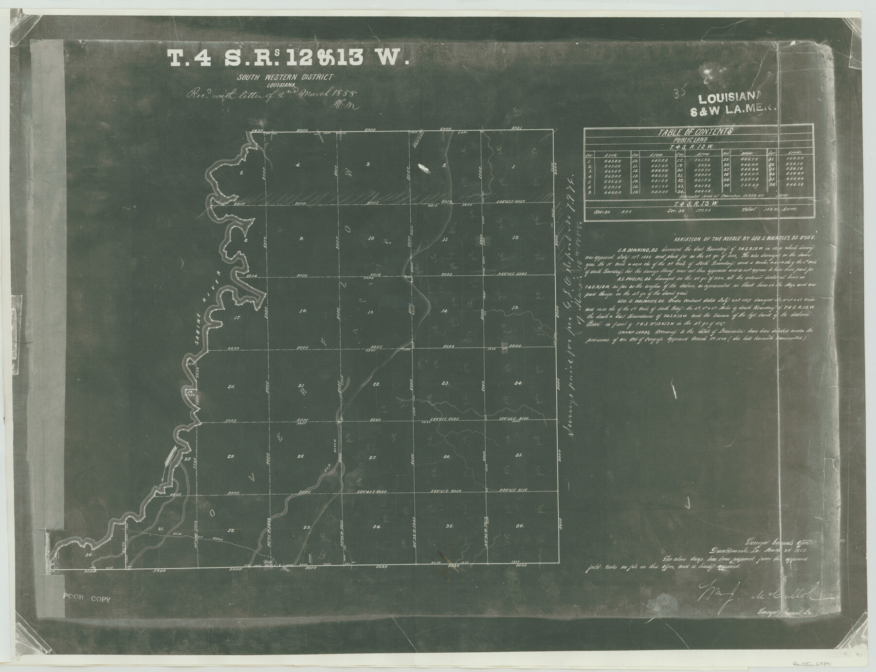
Township 4 South Ranges 12 and 13 West, South Western District, Louisiana
Louisiana Township
-
Map/Doc
65891
-
Collection
General Map Collection
-
Object Dates
1857 (Creation Date)
-
People and Organizations
Department of the Interior (Publisher)
Geo. S. Walmsley (Surveyor/Engineer)
-
Subjects
Texas Boundaries
-
Height x Width
18.6 x 24.2 inches
47.2 x 61.5 cm
-
Comments
Certifies that counter numbers 65890 and 65891 are photostatic copies of survey of Township 4 South of Ranges 12 and 13 West of the Louisiana Meridian, Louisiana.
Part of: General Map Collection
Johnson County Working Sketch 29

Print $20.00
- Digital $50.00
Johnson County Working Sketch 29
2006
Size 26.4 x 37.5 inches
Map/Doc 83060
Presidio County Working Sketch 113

Print $40.00
- Digital $50.00
Presidio County Working Sketch 113
1981
Size 48.9 x 37.1 inches
Map/Doc 71790
Smith County Rolled Sketch 6E2

Print $20.00
- Digital $50.00
Smith County Rolled Sketch 6E2
1960
Size 27.6 x 22.7 inches
Map/Doc 10613

Polk County Working Sketch 28

Print $40.00
- Digital $50.00
Polk County Working Sketch 28
1960
Size 53.5 x 43.6 inches
Map/Doc 71644
Fort Bend County Boundary File 4

Print $40.00
- Digital $50.00
Fort Bend County Boundary File 4
Size 18.5 x 26.2 inches
Map/Doc 53567
Edwards County Working Sketch 40

Print $20.00
- Digital $50.00
Edwards County Working Sketch 40
1949
Size 19.8 x 18.6 inches
Map/Doc 68916
Township 11 North Range 16 West, South Western District, Louisiana

Print $20.00
- Digital $50.00
Township 11 North Range 16 West, South Western District, Louisiana
1834
Size 19.7 x 24.7 inches
Map/Doc 65869
Presidio County Sketch File H

Print $4.00
- Digital $50.00
Presidio County Sketch File H
Size 5.8 x 9.6 inches
Map/Doc 34431
Uvalde County Working Sketch 22

Print $20.00
- Digital $50.00
Uvalde County Working Sketch 22
1950
Size 26.1 x 18.5 inches
Map/Doc 72092
Foard County Boundary File 1

Print $8.00
- Digital $50.00
Foard County Boundary File 1
Size 9.1 x 4.1 inches
Map/Doc 53500

You may also like
King County Working Sketch 16

Print $40.00
- Digital $50.00
King County Working Sketch 16
1979
Size 41.4 x 59.4 inches
Map/Doc 70180
Nueces County Working Sketch Graphic Index

Print $20.00
- Digital $50.00
Nueces County Working Sketch Graphic Index
1913
Size 24.0 x 32.3 inches
Map/Doc 76655
[Surveys in Austin's Colony along the San Bernardo River from the mouth of Peach Creek]
![209, [Surveys in Austin's Colony along the San Bernardo River from the mouth of Peach Creek], General Map Collection](https://historictexasmaps.com/wmedia_w700/maps/209.tif.jpg)
Print $20.00
- Digital $50.00
[Surveys in Austin's Colony along the San Bernardo River from the mouth of Peach Creek]
1821
Size 23.4 x 10.6 inches
Map/Doc 209
DeWitt County Sketch File 6

Print $24.00
- Digital $50.00
DeWitt County Sketch File 6
1872
Size 9.8 x 8.5 inches
Map/Doc 20805
Bailey County Sketch File 15

Print $18.00
- Digital $50.00
Bailey County Sketch File 15
1912
Size 8.7 x 11.2 inches
Map/Doc 13975
Index to Titles, Field, Notes, and Plats, A-Z

Index to Titles, Field, Notes, and Plats, A-Z
Size 17.0 x 12.1 inches
Map/Doc 94525
Bosque County Working Sketch 31

Print $20.00
- Digital $50.00
Bosque County Working Sketch 31
2010
Size 29.8 x 34.6 inches
Map/Doc 89277
National Map Company's New Road Survey of the United States Showing Main Highways

Print $20.00
- Digital $50.00
National Map Company's New Road Survey of the United States Showing Main Highways
Size 44.3 x 38.2 inches
Map/Doc 4674
Stonewall County Rolled Sketch 11

Print $20.00
- Digital $50.00
Stonewall County Rolled Sketch 11
Size 33.2 x 28.1 inches
Map/Doc 7867
General Highway Map, Oldham County, Texas

Print $20.00
General Highway Map, Oldham County, Texas
1961
Size 24.6 x 18.2 inches
Map/Doc 79620
Flight Mission No. CUG-1P, Frame 107, Kleberg County

Print $20.00
- Digital $50.00
Flight Mission No. CUG-1P, Frame 107, Kleberg County
1956
Size 18.5 x 22.3 inches
Map/Doc 86157
Crosby County Sketch File 31

Print $20.00
- Digital $50.00
Crosby County Sketch File 31
Size 35.0 x 14.0 inches
Map/Doc 11257