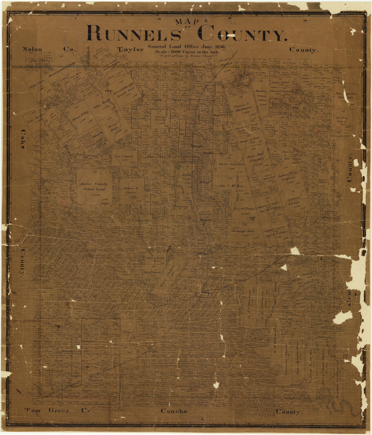
Map of Runnels County
-
Map/Doc
16803
-
Collection
General Map Collection
-
Object Dates
1898 (Creation Date)
-
People and Organizations
Texas General Land Office (Publisher)
Herman Pressler (Draftsman)
Herman Pressler (Compiler)
-
Counties
Runnels
-
Subjects
County
-
Height x Width
43.2 x 36.9 inches
109.7 x 93.7 cm
-
Comments
Conservation funded in 2002 with donation from Mr. and Mrs. Howard Barr.
-
Features
Miles
Red Creek
Hatchel
Runnels
Norwood
GC&SF
Ballinger
Wire Hollow
Rowena
Grape Creek
A&S
Oath Creek
Colorado River
Concho River
Church Mountain
Mustang Creek
Black Creek
Horton
Clear Creek
Elm Creek
Valley Creek
Bluff Creek
Andra
Salt Creek
Fish Creek
Wingate
Moro Mountain
Buck Creek
Content
Table Mountain
Spring Creek
Oak Creek
Mulatto Creek
Truitt
Coyote Creek
Winters
Mazeland
Long Branch [of Red Creek]
Crews
Part of: General Map Collection
[Nueces Bay, Mustang Island and Padre Island]
![73466, [Nueces Bay, Mustang Island and Padre Island], General Map Collection](https://historictexasmaps.com/wmedia_w700/maps/73466.tif.jpg)
Print $4.00
- Digital $50.00
[Nueces Bay, Mustang Island and Padre Island]
Size 18.3 x 25.3 inches
Map/Doc 73466
Gaines County Rolled Sketch 26

Print $20.00
- Digital $50.00
Gaines County Rolled Sketch 26
1980
Size 28.0 x 15.5 inches
Map/Doc 5940
Brazoria County

Print $20.00
- Digital $50.00
Brazoria County
1877
Size 25.0 x 22.2 inches
Map/Doc 4510
Uvalde County Sketch File 12A

Print $20.00
- Digital $50.00
Uvalde County Sketch File 12A
1887
Size 19.2 x 30.0 inches
Map/Doc 12527

Andrews County Working Sketch 23

Print $20.00
- Digital $50.00
Andrews County Working Sketch 23
1979
Size 26.6 x 27.7 inches
Map/Doc 67069
Hood County Sketch File 27

Print $4.00
- Digital $50.00
Hood County Sketch File 27
1873
Size 12.9 x 8.5 inches
Map/Doc 26629

Edwards County Working Sketch 24

Print $20.00
- Digital $50.00
Edwards County Working Sketch 24
1942
Size 19.1 x 34.1 inches
Map/Doc 68900
Prison Property, Walker Co.

Print $20.00
- Digital $50.00
Prison Property, Walker Co.
Size 34.2 x 24.7 inches
Map/Doc 94283
Map of Refugio District

Print $20.00
- Digital $50.00
Map of Refugio District
1850
Size 22.6 x 25.1 inches
Map/Doc 1959
Borden County Rolled Sketch 8

Print $20.00
- Digital $50.00
Borden County Rolled Sketch 8
1951
Size 23.8 x 28.6 inches
Map/Doc 5159
You may also like
Menard County Rolled Sketch 14

Print $20.00
- Digital $50.00
Menard County Rolled Sketch 14
Size 39.8 x 34.1 inches
Map/Doc 6760
Sherman County Boundary File 4

Print $54.00
- Digital $50.00
Sherman County Boundary File 4
Size 8.9 x 8.5 inches
Map/Doc 58782
Brewster County Working Sketch 61

Print $20.00
- Digital $50.00
Brewster County Working Sketch 61
1955
Size 32.1 x 43.3 inches
Map/Doc 67662
Jefferson County Working Sketch 35

Print $20.00
- Digital $50.00
Jefferson County Working Sketch 35
1982
Size 39.1 x 32.6 inches
Map/Doc 66579
Chambers County Sketch File 58

Print $2.00
- Digital $50.00
Chambers County Sketch File 58
1995
Size 9.1 x 14.7 inches
Map/Doc 18108
Terrell County Working Sketch 66

Print $40.00
- Digital $50.00
Terrell County Working Sketch 66
1972
Size 32.1 x 48.1 inches
Map/Doc 69587
[Sketch of area around Geo. C. Kimball, M. G. Dickes, and S. F. Sanders surveys]
![92021, [Sketch of area around Geo. C. Kimball, M. G. Dickes, and S. F. Sanders surveys], Twichell Survey Records](https://historictexasmaps.com/wmedia_w700/maps/92021-1.tif.jpg)
Print $20.00
- Digital $50.00
[Sketch of area around Geo. C. Kimball, M. G. Dickes, and S. F. Sanders surveys]
Size 27.0 x 26.3 inches
Map/Doc 92021
Coleman County Sketch File 2

Print $2.00
- Digital $50.00
Coleman County Sketch File 2
Size 8.4 x 3.3 inches
Map/Doc 18669
El Paso County Boundary File 9

Print $14.00
- Digital $50.00
El Paso County Boundary File 9
Size 12.7 x 8.2 inches
Map/Doc 53111
Blocks 14, 15, and 16 Capitol Syndicate Subdivision of Capitol Land Reservation Leagues

Print $20.00
- Digital $50.00
Blocks 14, 15, and 16 Capitol Syndicate Subdivision of Capitol Land Reservation Leagues
1907
Size 26.2 x 37.1 inches
Map/Doc 90712
Henderson County Working Sketch 24

Print $20.00
- Digital $50.00
Henderson County Working Sketch 24
1952
Size 29.3 x 22.9 inches
Map/Doc 66157
Sabine Pass, Texas

Print $40.00
- Digital $50.00
Sabine Pass, Texas
1874
Size 32.2 x 53.2 inches
Map/Doc 69837