Borden County Sketch File 6
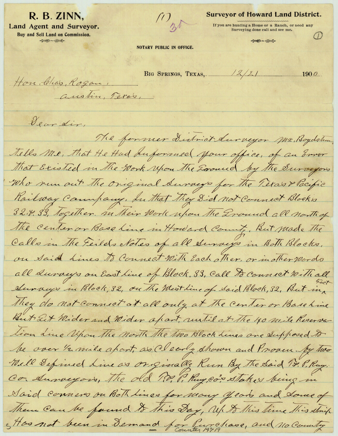
[Surveyor's statement regarding lines in T. & P. R.R. Blocks 32 and 33]
-
Map/Doc
14719
-
Collection
General Map Collection
-
Object Dates
1900/12/21 (Creation Date)
-
People and Organizations
R.B. Zinn (Surveyor/Engineer)
-
Counties
Borden
-
Subjects
Surveying Sketch File
-
Height x Width
11.2 x 8.7 inches
28.4 x 22.1 cm
-
Medium
paper, manuscript
Part of: General Map Collection
Frio County Rolled Sketch 21

Print $20.00
- Digital $50.00
Frio County Rolled Sketch 21
1961
Size 43.8 x 27.7 inches
Map/Doc 8911
Map of Nacogdoches County

Print $40.00
- Digital $50.00
Map of Nacogdoches County
1839
Size 83.3 x 79.2 inches
Map/Doc 16775
Bowie County Working Sketch 26

Print $20.00
- Digital $50.00
Bowie County Working Sketch 26
1980
Size 29.1 x 24.7 inches
Map/Doc 67430
Hockley County

Print $20.00
- Digital $50.00
Hockley County
1900
Size 41.5 x 36.7 inches
Map/Doc 16852
Bee County Sketch File X1

Print $20.00
- Digital $50.00
Bee County Sketch File X1
1834
Size 14.2 x 8.9 inches
Map/Doc 14245
Nueces County Rolled Sketch 122

Print $47.00
Nueces County Rolled Sketch 122
1996
Size 24.6 x 40.2 inches
Map/Doc 7153
Williamson County Sketch File 24

Print $12.00
- Digital $50.00
Williamson County Sketch File 24
1877
Size 12.8 x 8.1 inches
Map/Doc 40355
Dallas County Sketch File 24

Print $4.00
- Digital $50.00
Dallas County Sketch File 24
1860
Size 14.9 x 8.4 inches
Map/Doc 20459
Fractional Township No. 7 South Range No. 2 West of the Indian Meridian, Indian Territory

Print $20.00
- Digital $50.00
Fractional Township No. 7 South Range No. 2 West of the Indian Meridian, Indian Territory
1898
Size 19.2 x 24.4 inches
Map/Doc 75195
Brewster County Rolled Sketch 114

Print $20.00
- Digital $50.00
Brewster County Rolled Sketch 114
1964
Size 12.0 x 17.5 inches
Map/Doc 5291
Colorado County Sketch File 28

Print $17.00
- Digital $50.00
Colorado County Sketch File 28
1935
Size 9.1 x 7.7 inches
Map/Doc 18966
Karnes County Sketch File 13

Print $8.00
- Digital $50.00
Karnes County Sketch File 13
1897
Size 9.7 x 6.3 inches
Map/Doc 28611
You may also like
Map of Swisher Addition

Print $20.00
- Digital $50.00
Map of Swisher Addition
1910
Size 18.0 x 13.3 inches
Map/Doc 646
Pecos County Rolled Sketch 163

Print $20.00
- Digital $50.00
Pecos County Rolled Sketch 163
Size 28.2 x 23.9 inches
Map/Doc 7286
Flight Mission No. DAG-22K, Frame 86, Matagorda County

Print $20.00
- Digital $50.00
Flight Mission No. DAG-22K, Frame 86, Matagorda County
1953
Size 15.7 x 15.5 inches
Map/Doc 86470
Llano County Working Sketch 1

Print $20.00
- Digital $50.00
Llano County Working Sketch 1
1938
Size 19.5 x 19.2 inches
Map/Doc 70619
Bowie County Sketch File 7b

Print $10.00
- Digital $50.00
Bowie County Sketch File 7b
1927
Size 10.7 x 8.6 inches
Map/Doc 14859
East Half of Section 58. W. C. RR. Co. Block 3

Print $20.00
- Digital $50.00
East Half of Section 58. W. C. RR. Co. Block 3
1952
Size 8.7 x 18.8 inches
Map/Doc 92594
[West line of B. & B. Block 1]
![90584, [West line of B. & B. Block 1], Twichell Survey Records](https://historictexasmaps.com/wmedia_w700/maps/90584-1.tif.jpg)
Print $20.00
- Digital $50.00
[West line of B. & B. Block 1]
Size 12.7 x 15.2 inches
Map/Doc 90584
Hardin County Rolled Sketch 22

Print $20.00
- Digital $50.00
Hardin County Rolled Sketch 22
1977
Size 32.0 x 44.4 inches
Map/Doc 9110

Upton County Sketch File 8

Print $4.00
- Digital $50.00
Upton County Sketch File 8
1913
Size 14.4 x 8.8 inches
Map/Doc 38822

Southern Pacific Railway and Steamship Lines

Print $20.00
- Digital $50.00
Southern Pacific Railway and Steamship Lines
1900
Size 23.8 x 35.5 inches
Map/Doc 96586