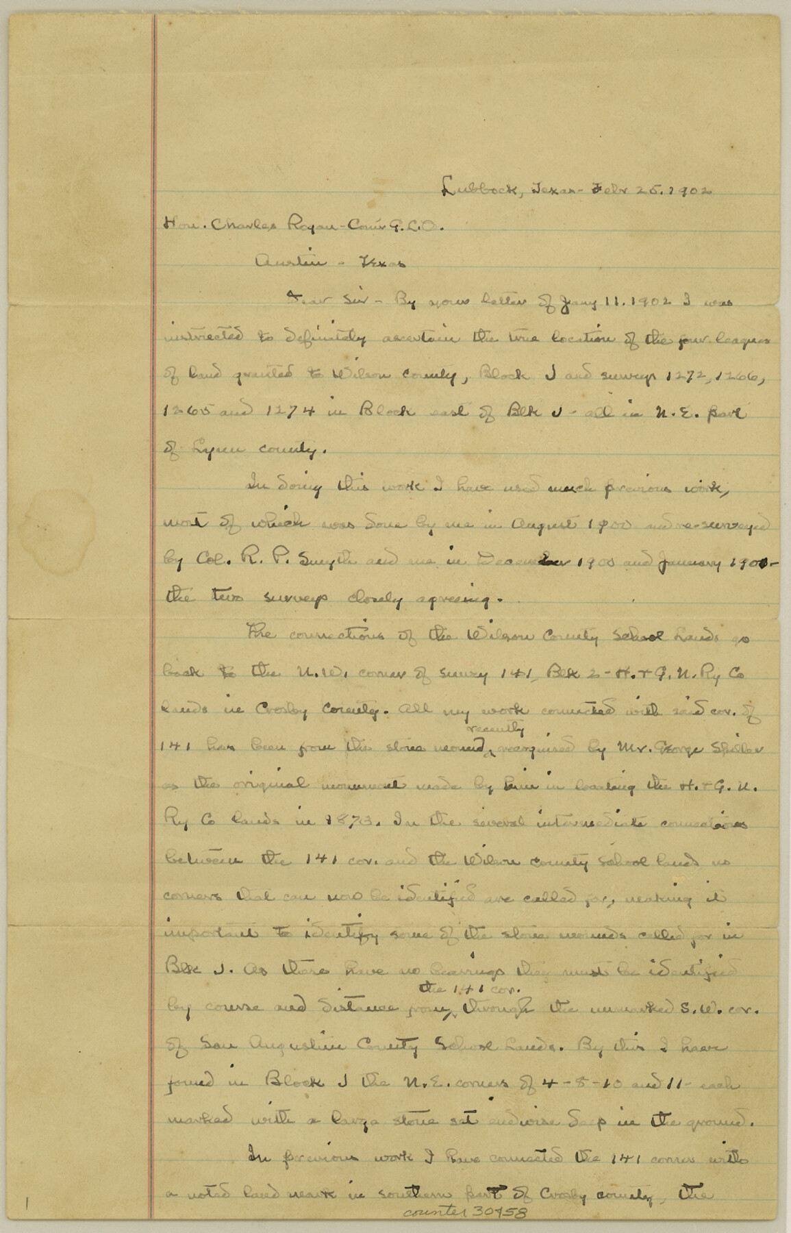
Lynn County Sketch File 4
[Connecting lines to Wilson County School Lands]
-
Map/Doc
30458
-
Collection
General Map Collection
-
Object Dates
2/25/1902 (Creation Date)
3/21/1902 (File Date)
2/25/1902 (Correspondence Date)
8/1900 (Survey Date)
3/15/1902 (Correspondence Date)
-
People and Organizations
C.W. Holt (Surveyor/Engineer)
George Spiller (Surveyor/Engineer)
Henry Knight (Surveyor/Engineer)
-
Counties
Lynn Crosby Lubbock
-
Subjects
Surveying Sketch File
-
Height x Width
12.8 x 8.2 inches
32.5 x 20.8 cm
-
Medium
paper, manuscript
-
Features
Yellow House Canon
Guthrie Lake
Double Lakes
Part of: General Map Collection
Map of the Rio Grande & Eagle Pass Ry. from Sections 21-25 9/10 Inclusive, Webb County

Print $40.00
- Digital $50.00
Map of the Rio Grande & Eagle Pass Ry. from Sections 21-25 9/10 Inclusive, Webb County
1909
Size 25.8 x 55.4 inches
Map/Doc 64658
Coleman County Sketch File 42

Print $24.00
- Digital $50.00
Coleman County Sketch File 42
1891
Size 5.8 x 8.9 inches
Map/Doc 18763
Val Verde County Working Sketch 70

Print $20.00
- Digital $50.00
Val Verde County Working Sketch 70
1966
Size 21.2 x 28.0 inches
Map/Doc 72205
Kimble County Sketch File 9a

Print $4.00
- Digital $50.00
Kimble County Sketch File 9a
Size 12.4 x 9.2 inches
Map/Doc 28929
Map of the City of Austin Texas

Map of the City of Austin Texas
1933
Size 22.6 x 17.6 inches
Map/Doc 1685
Hamilton County Working Sketch 11

Print $20.00
- Digital $50.00
Hamilton County Working Sketch 11
1949
Size 45.1 x 43.7 inches
Map/Doc 63349
Bell County Sketch File 29a

Print $4.00
- Digital $50.00
Bell County Sketch File 29a
1875
Size 12.4 x 8.6 inches
Map/Doc 14441
Motley County Sketch File B4 (N)

Print $20.00
- Digital $50.00
Motley County Sketch File B4 (N)
1900
Size 23.5 x 25.8 inches
Map/Doc 42151
Baylor County Boundary File 6

Print $82.00
- Digital $50.00
Baylor County Boundary File 6
Size 9.5 x 65.3 inches
Map/Doc 50400
Travis County Boundary File 20

Print $6.00
- Digital $50.00
Travis County Boundary File 20
Size 14.4 x 9.2 inches
Map/Doc 59454
Schleicher County Working Sketch 19

Print $20.00
- Digital $50.00
Schleicher County Working Sketch 19
1948
Size 43.5 x 38.9 inches
Map/Doc 63821
Gonzales County Working Sketch 10

Print $20.00
- Digital $50.00
Gonzales County Working Sketch 10
1981
Size 18.9 x 14.7 inches
Map/Doc 63226
You may also like
Coast Chart No. 212 - From Latitude 26° 33' to the Rio Grande Texas

Print $20.00
- Digital $50.00
Coast Chart No. 212 - From Latitude 26° 33' to the Rio Grande Texas
1886
Size 18.4 x 27.8 inches
Map/Doc 72826
Kendall County Sketch File 4

Print $4.00
- Digital $50.00
Kendall County Sketch File 4
Size 7.8 x 8.6 inches
Map/Doc 28684
Hartley County Sketch File 6

Print $20.00
- Digital $50.00
Hartley County Sketch File 6
Size 30.5 x 25.6 inches
Map/Doc 11698
Newton County Working Sketch 34

Print $20.00
- Digital $50.00
Newton County Working Sketch 34
1959
Size 27.0 x 32.6 inches
Map/Doc 71280

Flight Mission No. CGI-3N, Frame 110, Cameron County

Print $20.00
- Digital $50.00
Flight Mission No. CGI-3N, Frame 110, Cameron County
1954
Size 18.5 x 22.1 inches
Map/Doc 84590
Hardin County Working Sketch 15

Print $20.00
- Digital $50.00
Hardin County Working Sketch 15
1939
Size 21.1 x 34.6 inches
Map/Doc 63413
Armstrong County Sketch File 7

Print $6.00
- Digital $50.00
Armstrong County Sketch File 7
1902
Size 11.1 x 8.6 inches
Map/Doc 13702
Energy Map of Texas Ornament

Price $20.00
Energy Map of Texas Ornament
2021
Size 2.5 x 2.5 inches
Map/Doc 96574
Packery Channel

Print $2.00
- Digital $50.00
Packery Channel
1971
Size 9.2 x 9.1 inches
Map/Doc 2998
Kleberg County Rolled Sketch 10-14

Print $20.00
- Digital $50.00
Kleberg County Rolled Sketch 10-14
1951
Size 38.0 x 33.2 inches
Map/Doc 9404
Cooke County Working Sketch 18

Print $20.00
- Digital $50.00
Cooke County Working Sketch 18
1952
Size 23.5 x 19.6 inches
Map/Doc 68255