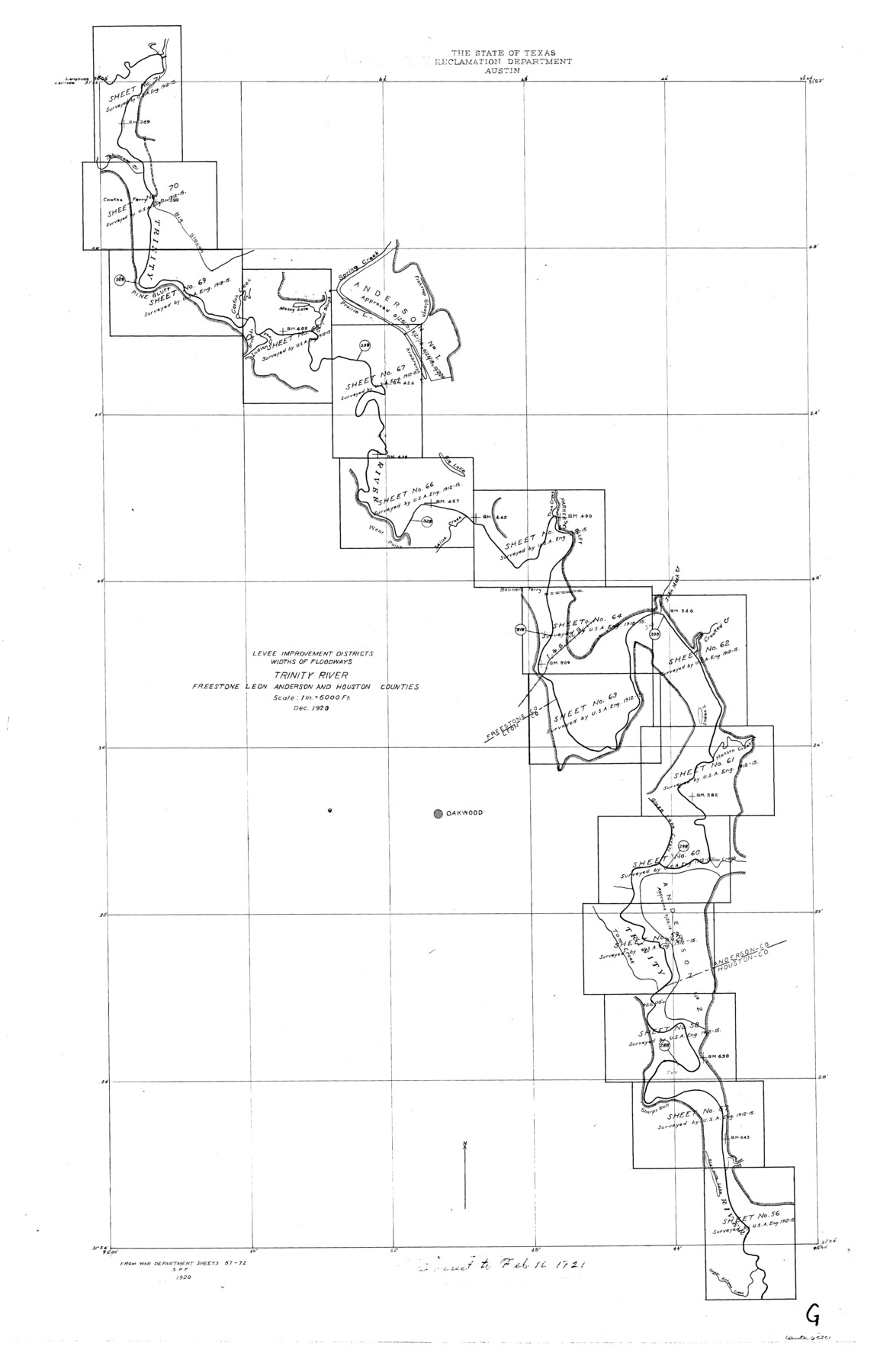
Trinity River, Levee Improvement Districts Widths of Floodways
-
Map/Doc
65251
-
Collection
General Map Collection
-
Object Dates
1920 (Creation Date)
-
People and Organizations
Texas State Reclamation Department (Publisher)
S.P. Floore (Draftsman)
S.P. Floore (Compiler)
-
Counties
Freestone Leon Anderson Houston
-
Subjects
River Surveys Topographic
-
Height x Width
33.3 x 21.7 inches
84.6 x 55.1 cm
-
Comments
Index of sheets 56 through 71 on the Trinity River.
Part of: General Map Collection
Atascosa County Rolled Sketch 11

Print $20.00
- Digital $50.00
Atascosa County Rolled Sketch 11
1943
Size 22.8 x 38.0 inches
Map/Doc 5094
Terrell County Rolled Sketch 57

Print $20.00
- Digital $50.00
Terrell County Rolled Sketch 57
1986
Size 33.0 x 25.2 inches
Map/Doc 7974
Martin County Rolled Sketch 6

Print $20.00
- Digital $50.00
Martin County Rolled Sketch 6
Size 25.8 x 26.9 inches
Map/Doc 6666
Brazoria County Sketch File 55

Print $80.00
- Digital $50.00
Brazoria County Sketch File 55
1899
Size 14.9 x 55.0 inches
Map/Doc 10327
Hardeman County Aerial Photograph Index Sheet 1

Print $20.00
- Digital $50.00
Hardeman County Aerial Photograph Index Sheet 1
1950
Size 19.8 x 17.0 inches
Map/Doc 83697
Rio Grande Rectification Project, El Paso and Juarez Valley

Print $20.00
- Digital $50.00
Rio Grande Rectification Project, El Paso and Juarez Valley
1935
Size 10.7 x 29.5 inches
Map/Doc 60869
Key to Photo Index Sheets of Texas Coast Portion

Print $20.00
- Digital $50.00
Key to Photo Index Sheets of Texas Coast Portion
1954
Size 20.0 x 24.0 inches
Map/Doc 83437
Yoakum County

Print $20.00
- Digital $50.00
Yoakum County
1902
Size 46.1 x 36.6 inches
Map/Doc 63138

[Sabine Pass]
![73343, [Sabine Pass], General Map Collection](https://historictexasmaps.com/wmedia_w700/maps/73343.tif.jpg)
Print $20.00
- Digital $50.00
[Sabine Pass]
1916
Size 18.5 x 26.5 inches
Map/Doc 73343
Parmer County Sketch File 1

Print $28.00
- Digital $50.00
Parmer County Sketch File 1
1902
Size 10.6 x 8.2 inches
Map/Doc 33621
Angelina County Sketch File 21b

Print $6.00
- Digital $50.00
Angelina County Sketch File 21b
1889
Size 13.9 x 8.5 inches
Map/Doc 13044
You may also like
Van Zandt County Rolled Sketch 10

Print $20.00
- Digital $50.00
Van Zandt County Rolled Sketch 10
1989
Size 33.7 x 40.6 inches
Map/Doc 10092
Hale County Sketch File 13

Print $20.00
- Digital $50.00
Hale County Sketch File 13
Size 36.5 x 23.0 inches
Map/Doc 10470
Flight Mission No. BRA-6M, Frame 147, Jefferson County

Print $20.00
- Digital $50.00
Flight Mission No. BRA-6M, Frame 147, Jefferson County
1953
Size 18.6 x 22.4 inches
Map/Doc 85448
Howard County

Print $20.00
- Digital $50.00
Howard County
1922
Size 44.0 x 37.5 inches
Map/Doc 66872
Hamilton County Working Sketch 22

Print $20.00
- Digital $50.00
Hamilton County Working Sketch 22
1955
Size 41.6 x 19.0 inches
Map/Doc 63360
Map of Karnes County

Print $20.00
- Digital $50.00
Map of Karnes County
1856
Size 26.2 x 22.4 inches
Map/Doc 3745
Jeff Davis County Sketch File 22

Print $20.00
- Digital $50.00
Jeff Davis County Sketch File 22
1923
Size 19.4 x 25.0 inches
Map/Doc 11860
[W. C. RR. Co. Blks. 1 & 2, I. & G. N. RR. Co. Blk. 1, in southeast part of County]
![90487, [W. C. RR. Co. Blks. 1 & 2, I. & G. N. RR. Co. Blk. 1, in southeast part of County], Twichell Survey Records](https://historictexasmaps.com/wmedia_w700/maps/90487-1.tif.jpg)
Print $2.00
- Digital $50.00
[W. C. RR. Co. Blks. 1 & 2, I. & G. N. RR. Co. Blk. 1, in southeast part of County]
1879
Size 6.5 x 5.8 inches
Map/Doc 90487
[Blocks R31E-R33E, Townships 12E-14E]
![92041, [Blocks R31E-R33E, Townships 12E-14E], Twichell Survey Records](https://historictexasmaps.com/wmedia_w700/maps/92041-1.tif.jpg)
Print $20.00
- Digital $50.00
[Blocks R31E-R33E, Townships 12E-14E]
Size 22.9 x 21.4 inches
Map/Doc 92041
Flight Mission No. DQO-3K, Frame 28, Galveston County

Print $20.00
- Digital $50.00
Flight Mission No. DQO-3K, Frame 28, Galveston County
1952
Size 18.1 x 22.3 inches
Map/Doc 85069
Harris County State Real Property Sketch 2

Print $32.00
- Digital $50.00
Harris County State Real Property Sketch 2
1999
Size 30.2 x 42.4 inches
Map/Doc 61702
Lampasas County Boundary File 3

Print $10.00
- Digital $50.00
Lampasas County Boundary File 3
Size 8.4 x 7.3 inches
Map/Doc 56101