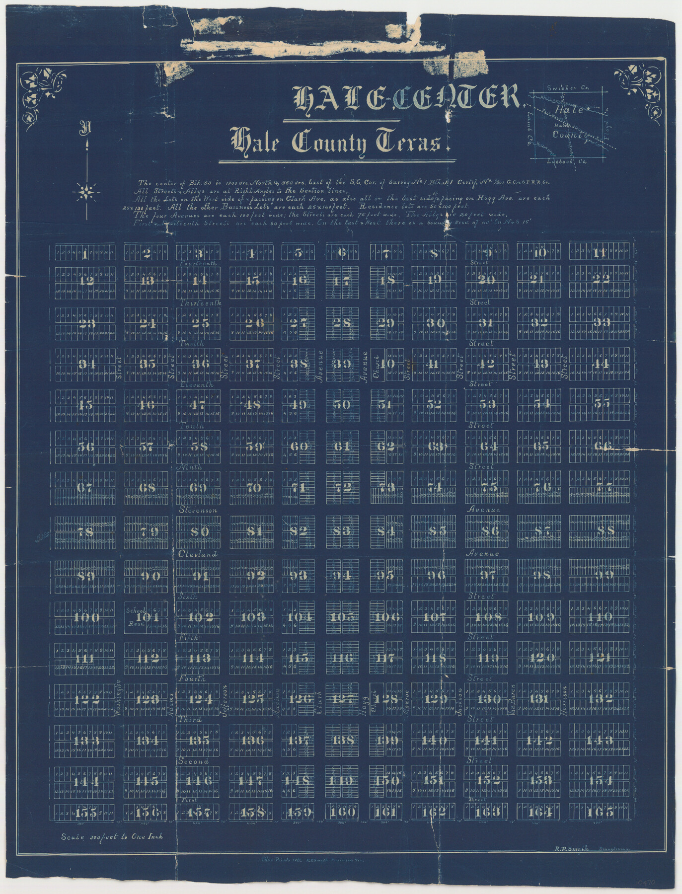
Hale County Sketch File 13
Hale Center, Hale County Texas
-
Map/Doc
10470
-
Collection
General Map Collection
-
Object Dates
1900/10/26 (File Date)
-
People and Organizations
R.P. Smyth (Draftsman)
-
Counties
Hale
-
Subjects
Surveying Sketch File
-
Height x Width
36.5 x 23.0 inches
92.7 x 58.4 cm
-
Medium
blueprint/diazo
-
Scale
1:300
-
Features
Sixth Street
First Street
Harrison Street
Van Buren Street
Jackson Street
Monroe Street
Clark Street
Madison Street
Jefferson Street
Adams Street
Third Street
Second Street
Washington Street
Fourth Street
Fifth Street
Clark Avenue
Clevland [sic] Avenue
Stevenson Avenue
Ninth Street
Tenth Street
Eleventh Street
Twelth [sic] Street
Thirteenth Street
Fourteenth Street
Fort Worth & Alberqueque Railroad
Crawfish Creek
White River Draw
Yellow House Creek
Plainview
Hogg Avenue
Part of: General Map Collection
Map of Copano, St. Charles, Aransas & Red Fish Bays in Aransas & Nueces Counties showing subdivision thereof for Mineral Development

Print $20.00
- Digital $50.00
Map of Copano, St. Charles, Aransas & Red Fish Bays in Aransas & Nueces Counties showing subdivision thereof for Mineral Development
1948
Size 35.9 x 34.0 inches
Map/Doc 2923
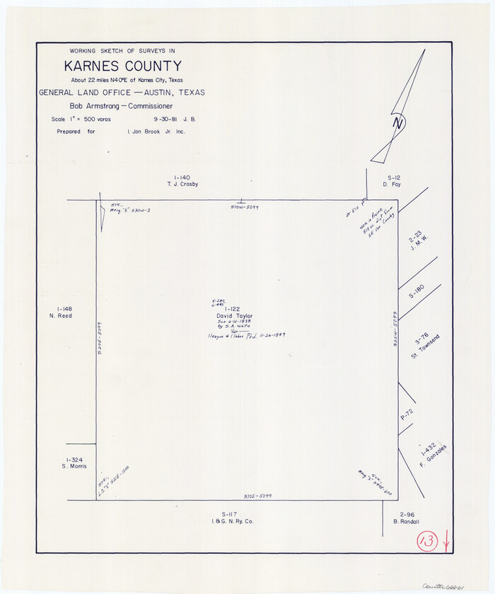
Karnes County Working Sketch 13
Print $20.00
- Digital $50.00
Karnes County Working Sketch 13
1981
Size 20.2 x 16.8 inches
Map/Doc 66661
The North Coast of the Gulf of Mexico from St. Marks to Galveston

Print $20.00
- Digital $50.00
The North Coast of the Gulf of Mexico from St. Marks to Galveston
1844
Size 27.5 x 41.1 inches
Map/Doc 97396
Kinney County Rolled Sketch 13

Print $20.00
- Digital $50.00
Kinney County Rolled Sketch 13
1949
Size 24.9 x 37.4 inches
Map/Doc 77562
Map of Rusk County

Print $20.00
- Digital $50.00
Map of Rusk County
1846
Size 31.6 x 20.6 inches
Map/Doc 4006
Jefferson County Sketch File 2

Print $50.00
- Digital $50.00
Jefferson County Sketch File 2
Size 11.2 x 8.8 inches
Map/Doc 28090
Brazos River Entrance

Print $20.00
- Digital $50.00
Brazos River Entrance
1925
Size 31.0 x 41.4 inches
Map/Doc 69974
[Surveys in the Jefferson District: G. A. Patillo's league, Big Sandy, Sabine Bay]
![69727, [Surveys in the Jefferson District: G. A. Patillo's league, Big Sandy, Sabine Bay], General Map Collection](https://historictexasmaps.com/wmedia_w700/maps/69727-1.tif.jpg)
Print $20.00
- Digital $50.00
[Surveys in the Jefferson District: G. A. Patillo's league, Big Sandy, Sabine Bay]
1846
Size 14.4 x 20.9 inches
Map/Doc 69727
Flight Mission No. BRE-1P, Frame 126, Nueces County

Print $20.00
- Digital $50.00
Flight Mission No. BRE-1P, Frame 126, Nueces County
1956
Size 18.4 x 22.4 inches
Map/Doc 86692
Bell County Working Sketch 5

Print $20.00
- Digital $50.00
Bell County Working Sketch 5
1942
Size 26.9 x 21.0 inches
Map/Doc 67345
Pecos County Rolled Sketch 62

Print $20.00
- Digital $50.00
Pecos County Rolled Sketch 62
1927
Size 44.2 x 39.4 inches
Map/Doc 9698
Sterling County Rolled Sketch 37

Print $20.00
- Digital $50.00
Sterling County Rolled Sketch 37
Size 25.4 x 31.8 inches
Map/Doc 7861
You may also like
Knox County Rolled Sketch 10A

Print $20.00
- Digital $50.00
Knox County Rolled Sketch 10A
Size 40.8 x 36.8 inches
Map/Doc 61734
Harris County Rolled Sketch 88

Print $20.00
- Digital $50.00
Harris County Rolled Sketch 88
1937
Size 34.9 x 22.7 inches
Map/Doc 6126
Flight Mission No. BRE-1P, Frame 69, Nueces County

Print $20.00
- Digital $50.00
Flight Mission No. BRE-1P, Frame 69, Nueces County
1956
Size 18.3 x 22.1 inches
Map/Doc 86651
Moore County Rolled Sketch 12

Print $20.00
- Digital $50.00
Moore County Rolled Sketch 12
Size 24.9 x 22.7 inches
Map/Doc 6828
Flight Mission No. BRE-1P, Frame 68, Nueces County

Print $20.00
- Digital $50.00
Flight Mission No. BRE-1P, Frame 68, Nueces County
1956
Size 17.7 x 21.8 inches
Map/Doc 86650
Ellwood Place, Installment No. 3

Print $20.00
- Digital $50.00
Ellwood Place, Installment No. 3
Size 17.8 x 24.9 inches
Map/Doc 92791
Trinity County Boundary File 102

Print $14.00
- Digital $50.00
Trinity County Boundary File 102
Size 9.2 x 4.6 inches
Map/Doc 59480
Henderson County Sketch File 12

Print $8.00
- Digital $50.00
Henderson County Sketch File 12
1871
Size 8.4 x 7.4 inches
Map/Doc 26349
Outer Continental Shelf Leasing Maps (Louisiana Offshore Operations)

Print $20.00
- Digital $50.00
Outer Continental Shelf Leasing Maps (Louisiana Offshore Operations)
1971
Size 20.2 x 15.0 inches
Map/Doc 76092
Menard County Sketch File 25A

Print $20.00
- Digital $50.00
Menard County Sketch File 25A
1936
Size 23.0 x 17.8 inches
Map/Doc 12078
Ward County Boundary File 3a

Print $22.00
- Digital $50.00
Ward County Boundary File 3a
Size 13.1 x 8.6 inches
Map/Doc 59684
Young County Rolled Sketch 14

Print $20.00
- Digital $50.00
Young County Rolled Sketch 14
1967
Size 17.7 x 22.7 inches
Map/Doc 8302